From today's featured articleThe Chestnuts Long Barrow is a chambered tomb located near the village of Addington in the south-eastern English county of Kent. Constructed during Britain's Early Neolithic period, it belongs to a regional style of barrows produced in the vicinity of the River Medway. The long barrows built in this area are now known as the Medway Megaliths. Chestnuts Long Barrow lies near both Addington Long Barrow and Coldrum Long Barrow on the western side of the river, and was built on land previously inhabited in the Mesolithic period. It consisted of an earthen mound, estimated to have been 15 metres (50 feet) in length, with a chamber built from sarsen megaliths on its eastern end. Human remains placed within this chamber during the Neolithic period were found alongside pottery sherds, stone arrow heads, and a clay pendant. The mound gradually eroded away and was gone by the twentieth century, leaving only the ruined stone chamber. (Full article...)
Recently featured:
Did you know ... Culture of S. aureus
|
In the news
On this dayJune 5: Constitution Day in Denmark; Naksa Day in Palestinian communities (1967)
|
From today's featured list
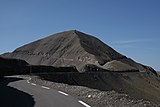
The highest point of elevation reached in the Tour de France is 2,802 metres (9,193 ft), at the Cime de la Bonette (pictured) in the Alps, a short loop road that forks from the summit of the Col de la Bonette, in the 1962 race. The Tour de France is an annual men's multiple-stage bicycle race primarily held in France, and generally considered to be the most famous bicycle race in the world. Its founder, Henri Desgrange, was passionate about taking the Tour up to the highest reachable points of elevation in the Alps and Pyrenees using the most difficult routes. The highest point of the first Tour de France in 1903 was the summit of the 1,161-metre-high (3,809 ft) Col de la République mountain pass in the Mont Pilat area of the Massif Central highland region. The race first reached high altitude on the ninth edition in 1910, when it passed the 2,115-metre-high (6,939 ft) Col du Tourmalet in the Pyrenees. (Full list...)
Today's featured picture

|
Perast is an old town on the Bay of Kotor in Montenegro. It is situated a few kilometres northwest of Kotor and is noted for its proximity to the islets of Saint George and Our Lady of the Rocks. Its history dates back to at least 1336, when it was the site of a small fishing village with a shipyard, but over time it became an important maritime centre. It prospered in the 16th century, when it was loyal to the Venetians at a time when the Republic of Venice and the Ottoman Empire were struggling for supremacy in the area. The wealthy merchants and sea captains built themselves grand palaces, mostly in the Baroque style, and there was a renowned naval college. Nowadays, the town relies on tourism for its income, and the number of residents has dwindled; it had a population of 274 at the last census. Photograph credit: Marcin Konsek
Recently featured:
|
Other areas of Wikipedia
- Community portal – Bulletin board, projects, resources and activities covering a wide range of Wikipedia areas.
- Help desk – Ask questions about using Wikipedia.
- Local embassy – For Wikipedia-related communication in languages other than English.
- Reference desk – Serving as virtual librarians, Wikipedia volunteers tackle your questions on a wide range of subjects.
- Site news – Announcements, updates, articles and press releases on Wikipedia and the Wikimedia Foundation.
- Village pump – For discussions about Wikipedia itself, including areas for technical issues and policies.
Wikipedia's sister projects
Wikipedia is hosted by the Wikimedia Foundation, a non-profit organization that also hosts a range of other projects:
Free media repository
Wiki software development
Wikimedia project coordination
Free textbooks and manuals
Free knowledge base
Free-content news
Collection of quotations
Free-content library
Directory of species
Free learning materials and activities
Free travel guide
Dictionary and thesaurus


