The Michigan Portal  Michigan (/ˈmɪʃɪɡən/ ⓘ MISH-ig-ən) is a state in the Great Lakes region of the Upper Midwestern United States. It shares water and land boundaries with Minnesota to the northwest, Wisconsin to the west, Indiana and Illinois to the southwest, Ohio to the southeast, and the Canadian province of Ontario to the east, northeast and north. With a population of 10.14 million and an area of 96,716 sq mi (250,490 km2), Michigan is the 10th-largest state by population, the 11th-largest by area, and the largest by total area east of the Mississippi River. The state capital is Lansing, while its most populous city is Detroit. The Metro Detroit region in Southeast Michigan is among the nation's most populous and largest metropolitan economies. Other important metropolitan areas include Grand Rapids, Flint, Ann Arbor, Kalamazoo, the Tri-Cities, and Muskegon. Michigan consists of two peninsulas: the heavily forested Upper Peninsula (commonly called "the U.P."), which juts eastward from northern Wisconsin, and the more populated Lower Peninsula, stretching north from Ohio and Indiana. The peninsulas are separated by the Straits of Mackinac, which connects Lake Michigan and Lake Huron, and are linked by the 5-mile-long Mackinac Bridge along Interstate 75. Bordering four of the five Great Lakes and Lake St. Clair, Michigan has the longest freshwater coastline of any U.S. political subdivision, measuring 3,288 miles. The state ranks second behind Alaska in water coverage by square miles and first in percentage, with approximately 42%, and it also contains 64,980 inland lakes and ponds. In the 17th century, French explorers claimed the Great Lakes region for New France, though the area had largely been inhabited for thousands of years by Indigenous peoples such as the Ojibwe, Odawa, Potawatomi, and Wyandot. French settlers and Métis established forts and settlements, with the region’s name derived from the Ojibwe word ᒥᓯᑲᒥ (mishigami), meaning "large water" or "large lake". After France's defeat in the French and Indian War in 1762, the area came under British control and later the U.S. following the Treaty of Paris (1783), though control remained disputed with Indigenous tribes until treaties between 1795 and 1842. The area was part of the larger Northwest Territory; the Michigan Territory was organized in 1805. Michigan was admitted as the 26th state on January 26, 1837, entering as a free state and quickly developing into an industrial and trade hub that attracted European immigrants, particularly from Finland, Macedonia, and the Netherlands. In the 1930s, migration from Appalachia and the Great Migration of Black Southerners further shaped the state, especially in Metro Detroit. Michigan has a diversified economy with a gross state product of $711.481 billion as of Q3 2024, ranking 14th among the 50 states. Although the state has developed a diverse economy, in the early 20th century it became widely known as the center of the U.S. automotive industry, which developed as a major national economic force. It is home to the country's three major automobile companies (whose headquarters are all in Metro Detroit). Once exploited for logging and mining, today the sparsely populated Upper Peninsula is important for tourism because of its abundance of natural resources. The Lower Peninsula is a center of manufacturing, forestry, agriculture, services, and high-tech industry. (Full article...) Entries here consist of Good and Featured articles, which meet a core set of high editorial standards.
Powder House Island (also known as Dynamite Island) is an artificial island on the lower Detroit River in southeast Michigan, directly adjacent to the Canada–United States border. It was constructed in the late 1880s by the Dunbar & Sullivan Company to store explosives during their dredging of the Livingstone Channel, with the purpose of circumventing an 1880 court order forbidding the company to store explosives on nearby Fox Island. Powder House Island was the location of dynamite storage sheds, as well as a dynamite factory and several ice houses. During this time, it was the site of a series of accidents, including fires in 1895 and 1919 (which both burned the island "to the water's edge"). Twenty short tons (18,000 kg) of the island's dynamite exploded in 1906 after two men "had been shooting with a revolver" near it; while there were no deaths (and only minor injuries to the two men), windows were shattered 3 mi (4.8 km) away and the explosion was clearly audible from 85 mi (137 km) away. (Full article...) Selected picture -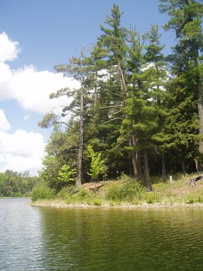 Sylvania Wilderness is an 18,327-acre (74 km2) area of land located a few miles west of Watersmeet, Michigan. The area is located entirely within the bounds of the Ottawa National Forest, and is currently being managed as a wilderness area as part of the National Wilderness Preservation System by the U.S. Forest Service. Did you know -
Related portalsSelected article -Lansing (/ˈlænsɪŋ/) is the capital of the U.S. state of Michigan and the most populous city in Ingham County. It is mostly in the county, although portions of the city extend west into Eaton County and north into Clinton County. The 2020 census placed the city's population at 112,644, making it the sixth most populous city in Michigan. The population of its metropolitan statistical area (MSA) was 541,297 at the 2020 census, the third largest in the state after metropolitan Detroit and Grand Rapids. It was named the new state capital of Michigan in 1847, ten years after Michigan became a state. The Lansing metropolitan area, colloquially referred to as "Mid-Michigan", is an important center for educational, cultural, governmental, commercial, and industrial functions. Neighboring East Lansing is home to Michigan State University, a public research university with an enrollment of more than 50,000. The area features two medical schools, one veterinary school, two nursing schools, and two law schools. It is the site of the Michigan State Capitol, the state Supreme Court, the Court of Appeals, a federal court, the Library of Michigan and Historical Center, and headquarters of four national insurance companies. (Full article...) Selected biography -William Francis Murphy (April 13, 1890 – July 19, 1949) was an American politician, lawyer, and jurist from Michigan. He was a Democrat who was named to the Supreme Court of the United States in 1940 after a political career that included serving as United States Attorney General, 35th governor of Michigan, and Mayor of Detroit. He also served as the last Governor-General of the Philippines and the first High Commissioner to the Philippines. Born in "The Thumb" region of Michigan, Murphy graduated from the University of Michigan Law School in 1914. After serving in the United States Army during World War I, he served as a federal attorney and trial judge. He served as Mayor of Detroit from 1930 to 1933. A panel of 69 scholars in 1993 ranked him among the ten best mayors in American history. In 1933 he was appointed as Governor-General of the Philippine Islands. He returned home in 1936 and defeated incumbent Republican governor Frank Fitzgerald in the 1936 Michigan gubernatorial election and served a single term as Governor of Michigan. Murphy lost re-election to Fitzgerald in 1938 and accepted an appointment as the United States Attorney General the following year. (Full article...) General imagesThe following are images from various Michigan-related articles on Wikipedia.
TopicsCategoriesSymbols
Lists
Related pagesWikimediaThe following Wikimedia Foundation sister projects provide more on this subject:
Things you can doDiscover Wikipedia using portals | ||||||||||||||||||||||||||||||||||||


