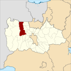
Rumpin (Sundanese:ᮛᮥᮙ᮪ᮕᮤᮔ᮪) is a town and an administrative district (kecamatan) in Bogor Regency, in the Province of West Java, Indonesia, and thus part of Jakarta's metropolitan area.. This district has a postal code of 16350.[2]
Rumpin
ᮛᮥᮙ᮪ᮕᮤᮔ᮪ | |
|---|---|
Town and District | |
 Rumpin location in Bogor Regency | |
| Motto(s): | |
 | |
| Country | |
| Province | West Java |
| Regency | Bogor Regency |
| Government | |
| • Camat | Dr. Rusliandy, S. STP, M.Si, M.E. |
| Area | |
| • Land | 117.75 km2 (45.46 sq mi) |
| Elevation | 94 m (308 ft) |
| Population (mid 2023 estimate)[1] | |
• Total | 153,211 |
| Time zone | UTC+7 (WIB) |
| Postal code | 16350 |
| Area codes | 0251 |
| Vehicle registration | F |
| Villages | 14 |
| Website | kecamatanrumpin |
Rumpin District covers an area of 117.75 km2, and had a population of 129,150 at the 2010 Census[3] and 146,007 at the 2020 Census;[4] the official estimate as at mid 2023 was 153,211 - comprising 79,848 males and 73,363 females.[1] The administrative centre is at the town of Rumpin, and the district is sub-divided into fourteen villages (desa), all sharing the postcode of 16350, as listed below with their areas and populations as at mid 2023.[1]
| Kode Wilayah |
Name of desa |
Area in km2 |
Population mid 2023 estimate |
|---|---|---|---|
| 32.01.18.2001 | Rumpin (town) | 4.78 | 7,191 |
| 32.01.18.2002 | Leuwibatu | 14.20 | 10,911 |
| 32.01.18.2003 | Cidokom | 5.54 | 8,780 |
| 32.01.18.2004 | Gobang | 6.38 | 8,939 |
| 32.01.18.2005 | Cibodas | 9.14 | 14,530 |
| 32.01.18.2006 | Rabak | 15.56 | 10,764 |
| 32.01.18.2007 | Kampung Sawah | 6.50 | 12,357 |
| 32.01.18.2008 | Cipinang | 9.96 | 15,951 |
| 32.01.18.2009 | Sukasari | 8.55 | 13,707 |
| 32.01.18.2010 | Tamansari | 9.97 | 8,049 |
| 32.01.18.2011 | Kertajaya | 6.67 | 14,309 |
| 32.01.18.2012 | Sukamulya | 10.70 | 14,739 |
| 32.01.18.2013 | Mekarsari | 5.80 | 7,953 |
| 32.01.18.2014 | Mekarjaya | 4.00 | 5,031 |
| 32.01.18 | Totals | 117.75 | 153,211 |
Demographics
editEthnic groups
editRumpin is home to the Sundanese people, who are the original inhabitants of West Java. There is no official data on the number of ethnic groups in Rumpin, but as a whole it is dominated by Sundanese. In addition, there are a small number of people who are Betawi. There are also a small portion of Javanese and Chinese, who are widely found in the Rumpin area.[5]
Religion
editThe majority of the population of Rumpin District embraces the religion of Islam, but a small portion follow Christianity and Buddhism, the latter adhered to by the minority Chinese. The original inhabitants in West Java (namely the Sundanese) generally embrace Islam, although some embrace the original beliefs of the Sundanese tribe, namely Sunda Wiwitan.
Language
editSundanese which is the original and dominant language in West Java, affects the language of communication used in social life. Sundanese is the main language used by the people of Rumpin and West Java in general, apart from Indonesian which is the official language of Indonesia.
Bordering Districts
editRumpin District is directly adjacent to Cisauk District of South Tangerang city (in Banten Province) to the north, to Rancabungur, Ciseeng (to which it is connected by the Gerendong Bridge) and Gunung Sindur Districts to the east, Cigudeg and Parung Panjang Districts to the west, and Leuwisadeng, Leuwiliang and Cibungbulang Districts to the south.
| Direction | Adjoining Area |
|---|---|
| North | Cisauk District (of South Tangerang city within Banten Province) |
| South | Leuwisadeng, Leuwiliang and Cibungbulang Districts |
| East | Rancabungur, Ciseeng and Gunungsindur Districts |
| West | Cigudeg and Parung Panjang Districts |
References
edit- ^ a b c Badan Pusat Statistik, Jakarta, 26 September 2024, Kecamatan Rumpin Dalam Angka 2024 (Katalog-BPS 1102001.3201260)
- ^ "Kecamatan Rumpin". kecamatanrumpin.bogorkab.go.id (in Indonesian). Retrieved June 11, 2021.
- ^ Biro Pusat Statistik, Jakarta, 2011.
- ^ Badan Pusat Statistik, Jakarta, 2021.
- ^ "Bogor Regency news". Retrieved 2 January 2021.
- ^ "Religion in Rumpin". December 1, 2010. Retrieved January 2, 2021.