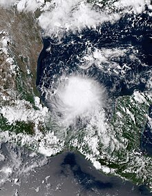
 Potential Tropical Cyclone Four soon after peak intensity in the Bay of Campeche on August 19 | |
| Meteorological history | |
|---|---|
| Formed | August 19, 2022 |
| Dissipated | August 21, 2022 |
| Potential tropical cyclone | |
| 1-minute sustained (SSHWS/NWS) | |
| Highest winds | 35 mph (55 km/h) |
| Lowest pressure | 1009 mbar (hPa); 29.80 inHg |
| Overall effects | |
| Fatalities | 0 |
| Damage | Minimal |
| Areas affected | Tamaulipas, South Texas |
Part of the 2022 Atlantic hurricane season | |
Potential Tropical Cyclone Four was a weak tropical disturbance that impacted northeastern Mexico and southern Texas in August 2022. As of December 2024, it is one of only three systems to be designated a Potential Tropical Cyclone and not form, along with Potential Tropical Cyclone Ten of the 2017 and Potential Tropical Cyclone Seventeen-E of the 2019.[1][2] The disturbance was first noted as a tropical wave in the central Caribbean Sea on August 15.[3] The system emerged in the southern Gulf of Mexico early on August 19, producing disorganized showers.[4] It was this point when the National Hurricane Center (NHC) started to issue advisories on the system as Potential Tropical Cyclone Four at 21:00 UTC. as the disturbance moved across the western Gulf, Four failed to develop a defined center and at the same time, deep convection significantly decreased. The disturbance moved inland over northeastern Mexico on 00:00 UTC on August 21 and soon after, dissipated.[5]
Metrological history
editTropical storm (39–73 mph, 63–118 km/h)
Category 1 (74–95 mph, 119–153 km/h)
Category 2 (96–110 mph, 154–177 km/h)
Category 3 (111–129 mph, 178–208 km/h)
Category 4 (130–156 mph, 209–251 km/h)
Category 5 (≥157 mph, ≥252 km/h)
Unknown
The origins of Potential Tropical Cyclone Four can be traced back to a tropical wave in the central Caribbean Sea on August 15.[6] The wave emerged over Bay of Campeche early on August 19, producing disorganized showers.[7] The NHC decide that the threat that the system posed to northeastern Mexico and South Texas was big enough to initiate advisories on Potential Tropical Cyclone Four at 21:00 UTC that same day.[5] As Four moved northwestwards in the Gulf of Mexico on August 20, hurricane hunter aircraft investigated the system on and found that the system was still a surface trough.[8] At around 00:00 UTC on August 21, it moved inland about 60 mi (95 km) southwest of the mouth of the Rio Grande.[9] Since it was clear at this point that the system would no longer develop into a tropical cyclone, the last warning was issued for Four at 03:00 UTC on August 21.[5]
Preparations and impact
editWhen the disturbance was designated, the Government of Mexico and the National Weather Service office in Brownsville, Texas issued a tropical storm warning from Boca de Catan, Mexico to Port Mansfield, Texas. The tropical storm warning was lifted after the disturbance moved inland on August 21.[5]
Four brought heavy rains and minor flooding to the Texas coast and northeastern Mexico.[10] However, there was no significant damage related to the storm.[5]
See also
edit- Weather of 2022
- Tropical cyclones in 2022
- Timeline of the 2022 Atlantic hurricane season
- Potential Tropical Cyclone Ten - Impacted the US East Coast, also didn't develop into a tropical cyclone
- Potential Tropical Cyclone Seventeen-E - Caused seven deaths in southern Mexico, also didn't develop into a tropical cyclone
References
edit- ^ Daniel P. Brown (January 26, 2018). Potential Tropical Cyclone Ten (PDF) (Report). Tropical Cyclone Report. Miami, Florida: National Hurricane Center. Retrieved January 28, 2023.
- ^ Pasch, Richard J. (February 28, 2020). "Potential Tropical Cyclone Seventeen-E Tropical Cyclone Report" (PDF). National Hurricane Center. Retrieved January 28, 2023.
- ^ Papin, Philippe (August 15, 2022). Five Day Graphical Tropical Weather Outlook (Report). Miami, Florida: National Hurricane Center. Retrieved February 5, 2023.
- ^ Cangialosi, John (August 19, 2022). Two Day Graphical Tropical Weather Outlook (Report). Miami, Florida: National Hurricane Center. Retrieved February 5, 2023.
- ^ a b c d e Cangialosi, John (November 1, 2022). Tropical Cyclone Report: Potential Tropical Cyclone Four (PDF) (Report). Miami, Florida: National Hurricane Center. Retrieved February 5, 2023.
- ^ Papin, Philippe (August 15, 2022). Five Day Graphical Tropical Weather Outlook (Report). Miami, Florida: National Hurricane Center. Retrieved February 5, 2023.
- ^ Cangialosi, John (August 19, 2022). Two Day Graphical Tropical Weather Outlook (Report). Miami, Florida: National Hurricane Center. Retrieved February 5, 2023.
- ^ Cangialosi, John; Latto, Andrew (August 20, 2022). Potential Tropical Cyclone Four Advisory Number 4 (Report). Miami, Florida: National Hurricane Center. Retrieved August 20, 2022.
- ^ "Potential Tropical Cyclone Four makes landfall in Mexico". New Orleans, Louisiana: WDSU. August 21, 2022. Retrieved August 21, 2022.
- ^ Team, WDSU Digital (2022-08-21). "Potential Tropical Cyclone Four makes landfall in Mexico". WDSU. Retrieved 2023-02-10.
External links
edit- The National Hurricane Center's advisory archive on Potential Tropical Cyclone Four