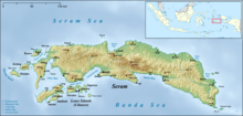
Wahai is a town on the northern coast of the Island of Seram,[1][2] North Seram District,[2] Indonesia,[1][2]. The Wahai Area has a total population of 11,000.[3] Agricultural clearing has resulted in deforestation in and around the area of Wahai[4]. Sometime before 1894, the Dutch established a fortified trader post[5] in Wahai, due to its strategic location[6], before it was placed under the jurisdiction of the civilian government in 1914[6].
On November 4, 2021, at roughly 10:42 local time, an earthquake measuring 5.7 Magnitude on the Richter Scale struck Seram Island, its epicenter being 16 kilometers west of the village. There were no reports of any fatalities caused by this, but at least three homes being damaged in the District Central Maluku.[7][8].

References
edit- ^ a b "East-Indonesia.info - East-Indonesia.info".
- ^ a b c "Informasi wilayah Wahai, kecamatan Seram Utara, kabupaten Maluku Tengah, provinsi Maluku, Indonesia".
- ^ https://pdf.usaid.gov/pdf_docs/PA00XBT3.pdf
- ^ Ellen, Roy (1997-01-01). "The human consequences of deforestation in the Moluccas". Civilisations. Revue internationale d'anthropologie et de sciences humaines (44): 176–193. doi:10.4000/civilisations.1628. ISSN 0009-8140.
- ^ https://libsysdigi.library.illinois.edu/oca/Books2008-08/universalgeograp/universalgeograp14recl/universalgeograp14recl.pdf
- ^ a b Valeri, Valerio (2000). The Forest of Taboos: Morality, Hunting, and Identity Among the Huaulu of the Moluccas. Univ of Wisconsin Press. ISBN 978-0-299-16214-6.
- ^ "Shallow quake rocks Indonesias Seram island, damage reported". anews. Retrieved 2022-05-24.
- ^ "Indonesia: Magnitude-5.7 earthquake occurs on Seram Island in Maluku Province at around 10:42 Nov. 4". Indonesia: Magnitude-5.7 earthquake occurs on Seram Island in Maluku Province at around 10:42 Nov. 4 | Crisis24. Retrieved 2022-05-24.