This is a page for me to place exit lists for various interstates so I can continue to work on them as need be. Please use my talk page to leave comments.


| County | Location | # | Destinations | Notes |
|---|---|---|---|---|
| Surry | 101 | I-77 leaves eastbound and joins westbound; exit 5 westbound | ||
| Surry | 6 | |||
| 8 | Red Brush Road | |||
| Mount Airy | 11 | |||
| 13 | Park Drive | |||
| 17 | US 52 joins eastbound and leaves westbound; exit 140 westbound | |||
| Randolph | 51 | |||
| 49 | New Hope Church Road | |||
| 45 | ||||
| Montgomery | 41 | Black Ankle Road | ||
| 39 | Ether, Steeds | |||
| 36 | Star, Robbins | |||
| Biscoe | 33 | |||
| Candor | 28 | |||

| Mile | County | Municipality | # | Destinations | Notes | ||
|---|---|---|---|---|---|---|---|
| Old | New | ||||||
| Miami-Dade | Miami | southbound exit and northbound entrance | |||||
| 1 | 1A | southbound exit and northbound entrance | |||||
| 2 | 1B | ||||||
| 3 | 2A | northbound exit and southbound entrance | |||||
| 3 | 2A | southbound exit and northbound entrance | |||||
| 3A | 2C | southbound exit and northbound entrance | |||||
| 4 | 2B | Northwest 2nd Street - Arenas (Miami Arena and AmericanAirlines Arena) | northbound exit and southbound entrance | ||||
| 5A | 3B | Northwest 8th Street - Port of Miami; Orange Bowl; Arenas (Miami Arena and AmericanAirlines Arena) | southbound exit and northbound entrance | ||||
| 5 | 2D | Midtown Interchange | |||||
| 6 | 3A | Midtown Interchange | |||||
| 7 | 4A | 36th Street Interchange; exit 4 southbound | |||||
| 7 | 4B | 36th Street Interchange; exit 4 southbound | |||||
| 8 | 6A | Northwest 62nd Street; Dr. Martin Luther King Jr. Boulevard | |||||
| 9A | 6B | Northwest 69th Street | southbound exit and northbound entrance | ||||
| 9 | 7 | ||||||
| 10 | 8A | Northwest 95th Street; Rev. Dr. A. Jackson Jr. Boulevard | |||||
| 11 | 8B | ||||||
| 12 | 9 | northbound exit and southbound entrance | |||||
| North Miami | 13 | 10A | |||||
| 14 | 10B | ||||||
| 15 | 11 | Northwest 151st Street | northbound exit and southbound entrance | ||||
| 16 | 12A | northbound exit and southbound entrance; Golden Glades Interchange | |||||
| 17 | 12B | northbound exit and southbound entrance; Golden Glades Interchange | |||||
| 18 | 12C | northbound exit and southbound entrance; Golden Glades Interchange | |||||
| 18 | 12 | southbound exit and northbound entrance; Golden Glades Interchange | |||||
| North Miami Beach | 19 | 14 | |||||
| 20 | 16 | Northeast 203rd Street; Ives Dairy Road (former State Road 854) | |||||
| Broward | Hallandale | 21 | 18 | ||||
| 22 | 19 | ||||||
| Hollywood | |||||||
| 23 | 20 | ||||||
| 24 | 21 | ||||||
| 25 | 22 | ||||||
| Dania | |||||||
| 26 | 23 | ||||||
| Fort Lauderdale | 26AB | 24 | southbound exit is combined with exit 26; "Rainbow Interchange" because of differently-colored bridges | ||||
| 27 | 25 | ||||||
| 28 | 26 | former exit 26CD southbound | |||||
| 29 | 27 | ||||||
| 30 | 29 | split into 29A and 29B northbound | |||||
| Oakland Park | 31 | 31 | split into 31A and 31B northbound | ||||
| 32 | 32 | ||||||
| 33 | 33 | Cypress Creek Road | split into 33A and 33B northbound | ||||
| Pompano Beach | 34 | 36 | split into 36A and 36B southbound | ||||
| 35 | 38 | Copans Road | split into 38A and 38B southbound | ||||
| 36 | 39 | ||||||
| Deerfield Beach | 36C | 41 | |||||
| 37 | 42 | split into 42A and 42B northbound | |||||
| Palm Beach | Boca Raton | 38 | 44 | Palmetto Park Road | |||
| 39 | 45 | ||||||
| 40 | 48 | split into 48A and 48B northbound | |||||
| 40C | 50 | Congress Avenue | |||||
| Delray Beach | 41 | 51 | Linton Boulevard | ||||
| 42 | 52 | ||||||
| Boynton Beach | 43 | 56 | Woolbright Road | ||||
| 44 | 57 | ||||||
| 44C | 59 | Gateway Boulevard | |||||
| Lantana | 45 | 60 | Hypoluxo Road | ||||
| 46 | 61 | ||||||
| Lake Worth | 47 | 63 | 6th Avenue South | ||||
| 48 | 64 | 10th Avenue North | |||||
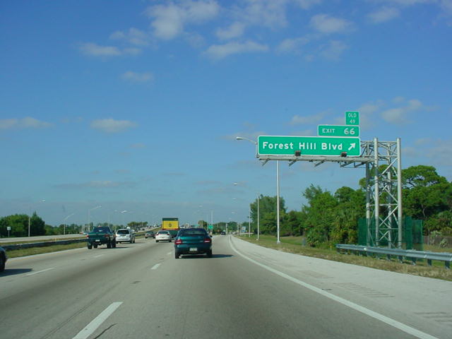
| West Palm Beach | 49 | 66 | There is no FL-882 designation on the exit sign for Forest Hill Boulevard[1] | ||||
| 50 | 68 | ||||||
| 51 | 69 | Belvedere Road; Palm Beach International Airport | split into 69A (Belvedere Road) and 69B (Airport) southbound | ||||
| 52 | 70 | ||||||
| 53 | 71 | Palm Beach Lakes Boulevard | |||||
| 54 | 74 | ||||||
| Riviera Beach | 55 | 76 | |||||
| Palm Beach Gardens | 56 | 77 | |||||
| 57 | 79AB | split into 79A and 79B northbound | |||||
| 57C | 79C | Military Trail south | southbound exit and northbound entrance | ||||
| 58 | 83 | Donald Ross Road | |||||
| Jupiter | 59 | 87 | split into 87A and 87B | ||||
| Martin | 60 | 96 | |||||
| 61 | 101 | ||||||
| 61C | 102 | ||||||
| 62 | 110 | ||||||
| St. Lucie | 63 | 118 | Gatlin Boulevard; Port Saint Lucie | ||||
| 63C | 121 | St. Lucie West Boulevard; Port Saint Lucie | |||||
| 64 | 126 | ||||||
| 65 | 129 | ||||||
| 66 | 131 | split into 131A and 131B | |||||
| 67 | 138 | ||||||
| Indian River | 68 | 147 | |||||
| 69 | 156 | ||||||
| Brevard | 70 | 173 | |||||
| 70A | 176 | ||||||
| 71 | 180 | ||||||
| 72 | 183 | ||||||
| 73 | 191 | ||||||
| 74 | 195 | ||||||
| 75 | 201 | ||||||
| 76 | 202 | ||||||
| 77 | 205 | ||||||
| 77C | 208 | Port St. John | |||||
| 78 | 212 | northbound exit and southbound entrance | |||||
| 78 | 212 | southbound exit and northbound entrance | |||||
| 79 | 215 | ||||||
| 80 | 220 | ||||||
| 81 | 223 | ||||||
| 82 | 231 | ||||||
| Volusia | 83 | 244 | |||||
| 84 | 249 | split into 249A and 249B southbound | |||||
| 85 | 256 | ||||||
| 86A | 260A | ||||||
| 86B | 260B | ||||||
| 87 | 261 | split into 261A and 261B southbound | |||||
| 87C | 265 | Holly Hill; Daytona Beach | |||||
| 88 | 268 | ||||||
| 89 | 273 | ||||||
| 90 | 278 | Old Dixie Highway | |||||
| Flagler | 91 | 284 | |||||
| 91C | 289 | Palm Coast | |||||
| St. Johns | 92 | 298 | |||||
| 93 | 305 | ||||||
| 94 | 311 | ||||||
| 95 | 318 | ||||||
| 95A | 323 | International Golf Parkway | |||||
| 96 | 329 | ||||||
| Duval | Jacksonville | 335 | St. Augustine Road | ||||
| 97 | 337 | ||||||
| 98 | 339 | ||||||
| 99 | 340 | northbound exit and southbound entrance | |||||
| 100 | 341 | ||||||
| 101 | 344 | ||||||
| 102 | 345 | Bowden Road to State Road 109; University Boulevard | northbound exit and southbound entrance | ||||
| 103 | 346 | southbound exit and northbound entrance; split into 346A and 346B | |||||
| 104 | 347 | ||||||
| 105 | 348 | southbound exit and northbound entrance | |||||
| 106 | 349 | southbound exit and northbound entrance | |||||
| 107 | 350A | ||||||
| 108 | 350B | San Marco Boulevard | southbound exit and northbound entrance | ||||
| 109 | 351A | Park Street | northbound exit and southbound entrance | ||||
| 112 | 351C | Margaret Street (permanently closed as of April 9, 2006) | southbound exit only | ||||
| 111 | 351B | ||||||
| 113 | 351D | Stockton Street | northbound exit is combined with exit 351B | ||||
| 114 | 352A | Myrtle Avenue | northbound exit and entrance | ||||
| 114A | 352B | Forsyth Street | northbound exit and southbound entrance | ||||
| 115 | 352C | Monroe Street | no southbound exit | ||||
| 116 | 353A | Church Street; Myrtle Avenue; Forsyth Street | northbound exit closed but signed | ||||
| 117 | 353B | ||||||
| 118 | 353C | ||||||
| 119 | 353D | ||||||
| 120 | 354 | split into 354A and 354B | |||||
| 121 | 355 | ||||||
| 122 | 356 | split into 356A and 356B northbound | |||||
| 123 | 357 | ||||||
| 124A | 358A | ||||||
| 124B | 358B | Broward Road | |||||
| 125 | 360 | ||||||
| 126A | 362A | ||||||
| 126B | 362B | ||||||
| 127 | 363 | split into 363A and 363B northbound | |||||
| 128 | 366 | Pecan Park Road | |||||
| Nassau | 129 | 373 | |||||
| 130 | 380 | ||||||
| County | # | Destinations | Notes |
|---|---|---|---|
| Camden | 1 | St. Mary's Road | Georgia Welcome Center at this exit |
| 3 | |||
| 6 | Laurel Island Parkway | ||
| 7 | Harriet's Bluff Road | ||
| 14 | |||
| 26 | Dover Bluff Road | ||
| Glynn | 29 | ||
| 36A-B | |||
| 38 | |||
| 42 | |||
| McIntosh | 49 | I-95 Business Loop is unsigned southbound | |
| 58 | |||
| Liberty | 67 | ||
| 76 | |||
| Bryan | 87 | ||
| 90 | |||
| Chatham | 94 | ||
| 99A-B | Unsigned | ||
| 102 | |||
| 104 | Savannah/Hilton Head International Airport | ||
| 106 | Jimmy Deloach Parkway | ||
| 109 | |||
| Exit | Route Number/Name | Destinations | Notes |
|---|---|---|---|
| 5 | Hardeeville, Savannah | ||
| 8 | Hilton Head, Sun City, Bluffton, Hardeeville | ||
| 18 | Road 13 | Switzerland | |
| 21 | South Carolina Highway 336 | Hilton Head Island, Ridgeland | |
| 22 | Ridgeland | US 17 joins northbound and leaves southbound | |
| 28 | South Carolina Highway 462 | Coosawhatchie, Hilton Head Island | |
| 33 | Charleston, Beaufort | US 17 joins southbound and leaves northbound | |
| 38 | South Carolina Highway 68 | Yemassee, Hampton | |
| 42 | Beaufort, Orangeburg | ||
| 53 | South Carolina Highway 63 | Walterboro, Varnville, Hampton, to |
|
| 57 | South Carolina Highway 64 | Walterboro, Lodge | |
| 62 | Road 34 | ||
| 68 | South Carolina Highway 61 | Canadys | |
| 77 | St. George, Branchville | ||
| 82 | Harleyville, Bowman | ||
| 86 | Columbia, Charleston | ||
| 90 | Holly Hill | ||
| 93 | Holly Hill | US 15 joins northbound and leaves southbound | |
| 97 | Orangeburg | Southbound only. US 301 joins northbound and leaves southbound | |
| 98 | South Carolina Highway 6 | Santee, Eutawville | |
| 102 | Santee | US 15-301 join southbound and leave northbound | |
| 108 | Road 102 | Summerton | |
| 115 | Manning, Summerton | ||
| 119 | South Carolina Highway 261 | Manning, Paxville | |
| 122 | South Carolina Highway 521 | Alcolu, Manning | |
| 132 | South Carolina Highway 527 | Sardinia, Kings Tree | |
| 135 | Tuberville, Sumter | ||
| 141 | SC 53, SC 58 | Shiloh | |
| 146 | South Carolina Highway 341 | Lynchburg, Lake City, Olanta | |
| 150 | South Carolina Highway 403 | Sardis, Timmonsville | |
| 153 | Honda Way | ||
| 157 | Florence, Timmonsville | ||
| 160 | Florence, Columbia | ||
| 164 | Florence, Darlington | ||
| 169 | TV Road | Quinby, Florence | |
| 170 | South Carolina Highway 327 | Marion, Myrtle Beach | |
| 181 | South Carolina Highway 38 | Marion, Latta, Myrtle Beach | |
| 190 | South Carolina Highway 34 | Dillon | |
| 193 | SC 9, SC 57 | Dillon, Bennettsville, Myrtle Beach |
| Exit | Route Number/Name | Destinations | Notes |
|---|---|---|---|
| 1 | Rowland, Laurinburg | Exit for South of the Border | |
| 2 | Rowland, Fairmont | ||
| 7 | Raynham Road, Sand Hole Road | McDonald, Raynham | |
| 10 | South Fairmont | US 301 joins northbound and leaves southbound | |
| 14 | Maxton, Laurinburg | ||
| 17 | Lumberton | ||
| 19 | Carthage Road | Southeastern Regional Medical Center | |
| 20 | Lumberton, Red Springs | ||
| 22 | local traffic | US 301 leaves northbound and joins southbound | |
| 25 | local traffic | ||
| 31 | St. Pauls, Raeford | ||
| 33 | Parkton | ||
| 40 | Fayetteville, Fort Bragg, Hope AFB | northbound only | |
| 41 | Hope Mills, Fayetteville | ||
| 44 | Claude Lee Road | Fayetteville Regional Airport | |
| 46 | Elizabethtown, Fayetteville | ||
| 49 | Fayetteville | ||
| 52 | Fayetteville, Clinton | ||
| 55 | NC 1832, Murphy Road | ||
| 56 | Fayetteville, Fort Bragg, Hope AFB | southbound only | |
| 58 | Newton Grove | Future | |
| 61 | Wade-Stedman Road | Wade | |
| 65 | Godwin, Falcon | ||
| 70 | NC 1811, Bud Hawkins Road | ||
| 71 | Long Branch Road | ||
| 72 | Joe Pope Road | ||
| 73 | Newton Grove, Clinton, Dunn | ||
| 75 | Jonesboro Road | ||
| 77 | Denning Road | ||
| 79 | Benson, Newton Grove | ||
| 81 | Raleigh, Wilmington | ||
| 87 | South Main Street | Four Oaks | Originally a split-diamond interchange with nearby Hockaday Road. |
| 90 | Newton Grove | ||
| 93 | Brogden Road | Smithfield | |
| 95 | Smithfield, Goldsboro | ||
| 97 | Selma, Pine Level | ||
| 98 | East Anderson Street | Selma | |
| 101 | Pittman Road | ||
| 102 | East Main Street | Micro | |
| 105 | Bagley Road | ||
| 106 | Flowers Road | ||
| 107 | Kenly, Wilson | ||
| 116 | Clayton, Rock Ridge, Wilson | ||
| 119 | Wilson, Greenville | ||
| 121 | Wilson, Greenville | ||
| 127 | Rocky Mount - Wilson Regional Airport | ||
| 132 | TO |
||
| 138 | Tarboro, Nashville, Rocky Mount | ||
| 141 | Red Oak | ||
| 145 | Gold Rock, Battleboro, Rocky Mount | ||
| 150 | Whitakers | ||
| 154 | Enfield | ||
| 160 | Louisburg | ||
| 168 | Halifax, Lake Gaston | ||
| 171 | |||
| 173 | Roanoke Rapids | ||
| 176 | Gaston, Garysburg | ||
| 180 |
| Number | Mile | Destinations | Notes | |
|---|---|---|---|---|
| Old | ||||
| 4 | 1 | |||
| 8 | 2 | |||
| 11 | 3 | split into 11A and 11B | ||
| 12 | 4 | northbound exit only | ||
| 13 | 5 | |||
| 17 | 6 | |||
| 20 | 7 | |||
| 24 | 8 | |||
| 31 | 9 | |||
| 33 | 10 | |||
| 37 | 11 | |||
| 41 | 12 | |||
| 45 | 13 | |||
| 46 | ||||
| 47 | ||||
| 48 | Wagner Road | split into 48A and 48B | ||
| 50A | exit 50 southbound; no southbound entrance; US 460 joins northbound and leaves southbound | |||
| 50BC | exit 50 southbound | |||
| 51 | 2 | US 460 joins southbound and leaves northbound | ||
| 52 | 3 | exit 50D northbound | ||
| 52 | Bank Street | northbound exit only | ||
| 53 | Southpark Boulevard | |||
| 54 | 4 | |||
| 58 | 5 | split into 58A and 58B southbound | ||
| 61 | 6 | split into 61A and 61B (old 6E and 6W; originally 6 with only one exit) | ||
| 62 | 6 | |||
| 64 | 6A | |||
| 67A | toll road | |||
| 67B | 7 | formerly exit 67 | ||
| 69 | 8 | |||
| 73 | 9 | Maury Street; Commerce Road | ||
| 74A | 9A | toll road | ||
| 74B | 10A | Franklin Street | southbound exit only | |
| 74C | 10 | |||
| 75 | 11 | I-64 joins northbound and leaves southbound | ||
| 76A | 12 | Chamberlayne Avenue | northbound exit and southbound entrance | |
| 76B | 13 | no northbound exit | ||
| 78 | 14 | |||
| 79 | 15A | I-64 joins southbound and leaves northbound | ||
| 80 | 15 | northbound exit and southbound entrance | ||
| 81 | 16 | northbound exit and southbound entrance | ||
| 82 | 17 | |||
| 83 | 35 | split into 83A and 83B | ||
| 84 | 36 | split into 84A and 84B | ||
| 86 | 37 | split into 86A and 86B | ||
| 89 | 38 | |||
| 92 | 39 | split into 92A and 92B northbound | ||
| 98 | 40 | |||
| 104 | 41 | |||
| 110 | 42 | |||
| 118 | 43 | |||
| 126 | 44 | split into 126A and 126B northbound; US 17 joins northbound and leaves southbound | ||
| 130 | 45 | split into 130A and 130B | ||
| 133 | 46 | split into 133A and 133B southbound; US 17 joins southbound and leaves northbound | ||
| 136 | exit opened December 22, 2005 | |||
| 140 | 47 | |||
| 143 | 48 | split into 143A and 143B | ||
| 148 | 49 | Marine Corps Base Quantico | ||
| 150 | 50 | split into 150A and 150B southbound | ||
| 152 | 51 | split into 152A and 152B | ||
| 156 | 52 | |||
| 158 | 52A | split into 158A and 158B | ||
| 160 | 53 | split into 160A and 160B southbound | ||
| 161 | 54 | northbound exit and southbound entrance | ||
| 161 | 54 | southbound exit and northbound entrance | ||
| 163 | 55 | State Route 642 - Lorton | ||
| 166 | 56 | split into 166A and 166B | ||
| 167 | State Route 617 south - Backlick Road; Fullerton Road | southbound exit only | ||
| full interchange with reversible HOV lane access only (ramps to/from the north only provide access to I-395) | ||||
| 169 | 57 | split into 169A and 169B | ||
| 170A | 4 | Originally meant to be part of I-95 through Washington D.C. | ||
| 170B | 58 | I-495 joins northbound and leaves southbound | ||
| 173 | 3 | |||
| 174 | 3A | Eisenhower Avenue Connector - Alexandria | ||
| 176 | 2 | split into 176A and 176B | ||
| 177 | 1 | split into 177A and 177B, and 177C (Mount Vernon) southbound | ||
| # | Destinations | Notes | |
|---|---|---|---|
| Old | |||
| 38 | 2B | ||
| 38 | 2A | outer exit only | |
| 37 | 3 | split into 3A (south) and 3B (north) | |
| 37A | 4 | split into 4A (west) and 4B (east) | |
| 36 | 7 | split into 7A (south) and 7B (north) | |
| 35 | 9 | ||
| 34 | 11 | split into 11A (south/east) and 11B (north/west) | |
| 13 | Ritchie-Marlboro Road - Upper Marlboro; Capitol Heights | ||
| 33 | 15 | split into 15A (east) and 15B (west) | |
| 16 | Arena Drive | Usually open only on event days at FedEx Field. | |
| 32 | 17 | split into 17A (east) and 17B (west) | |
| 31 | 19 | split into 19A (east) and 19B (west) | |
| 30 | 20 | split into 20A (east) and 20B (west) | |
| 29 | 22 | split into 22A (north) and 22B (south) | |
| 28 | 23 | ||
| 27 | 25 | split into 25A (north) and 25B (south) on inner loop | |
| 26 | 27 | I-495 leaves northbound and joins southbound | |
| 29 | split into 29A (east) and 29B (west) | ||
| 33 | split into 33A (east) and 33B (east) | ||
| 35 | split into 35A (east) and 35B (west) | ||
| 38 | split into 38A (east) and 38B (west) | ||
| 41 | split into 41A (east) and 41B (west) | ||
| 43 | split into 43A (east) and 43B (west) | ||
| 46 | northbound exit and southbound entrance | ||
| 47 | split into 47A (I-195 east) and 47B (MD 166 west) | ||
| 49 | split into 49A (east) and 49B (west) | ||
| 50 | split into 50A (south) and 50B (north) | ||
| 51 | Washington Boulevard | northbound exit and southbound entrance | |
| 52 | northbound exit and southbound entrance | ||
| 52 | southbound exit and northbound entrance | ||
| 53 | |||
| 54 | northbound exit and southbound entrance | ||
| 55 | |||
| Fort McHenry Tunnel $2.00 toll for cars | |||
| 56 | Keith Avenue | ||
| 57 | Boston Street; O'Donnell Street | ||
| 58 | Dundalk Avenue | northbound exit and southbound entrance | |
| 59 | |||
| 60 | Moravia Road | northbound exit and southbound entrance | |
| 61 | northbound exit and southbound entrance | ||
| southbound exit and northbound entrance | |||
| 2 | 64 | split into 64A (east) and 64B (west); exit numbers signed northbound only | |
| 3 | 67 | split into 67A (east) and 67B (west) | |
| 3A | 74 | ||
| 4 | 77 | split into 77A (south) and 77B (north) | |
| 80 | |||
| 5 | 85 | ||
| 6 | 89 | ||
| Millard E. Tydings Memorial Bridge $5.00 toll for cars (Northbound only) | |||
| 7 | 93 | ||
| 8 | 100 | split into 100A (south) and 100B (north) southbound | |
| 9 | 109 | split into 109A (south) and 109B (north) | |
| Number | Mile Post | Destinations |
|---|---|---|
| 1 | 2 | |
| 5 | Service Area | |
| 3 | 6 | |
| 4A | 7.6 | |
| 4B | 8 | |
| 5A | 10 | |
| 5B | 11.2 | |
| 5C | 10.6/12.8 | |
| 5D | 12 | |
| 6 | 14.5 | |
| 7 | 15.4 | |
| 8 | 16.7 | |
| 9 | 19 | |
| 10 | 21 | Harvey Road |
| 11 (North) | 23 | |
| 11 (South) | 23 | |
| Exit | Route Number/Name | Destinations | Notes |
|---|---|---|---|
| 1 | Chichester Avenue | ||
| 2 | Marcus Hook | ||
| 3 | Highland Avenue | Chester | |
| 3A | West Chester | Southbound only | |
| 4 | New Jersey | ||
| 5 | Kerlin Street | Northbound only | |
| 6 | To |
||
| 7 | Plymouth Meeting | ||
| 8 | Ridley Park | ||
| 9 | Essington, Prospect Park | ||
| 10 | Cargo City | Northbound only | |
| 12 | To |
||
| 13 | Valley Forge | ||
| 14 | Essington Avenue, Bartram Avenue | Southbound only | |
| 15 | Enterprise Avenue, Island Avenue | Southbound only | |
| 17 | Sports Complex | ||
| 19 | Walt Whitman Bridge | ||
| 20 | Columbus Boulevard, Washington Avenue | ||
| 22 | Central Philadelphia, Independence Hall | ||
| 23 | Girard Avenue, Lehigh Avenue | ||
| 25 | Allegheny Avenue, Castor Avenue | ||
| 26 | Betsy Ross Bridge | ||
| 27 | Bridge Street, Harbison Avenue | ||
| 30 | |||
| 32 | Academy Road, Linden Avenue | ||
| 35 | |||
| 37 | to |
||
| 40 | To |
Bristol | |
| Future interchange w/ PA Turnpike | |||
| 44 | Levittown, Penndel | ||
| 46 | Morrisville, Langhorne | ||
| 49 | Newtown, Yardley | ||
| 51 | New Hope, Yardley |

| County | Location | # | Destinations | Notes |
|---|---|---|---|---|
| Haywood | 7 | Harmon Den | ||
| 15 | Fines Creek | |||
| 20 | ||||
| 24 | ||||
| 27 | US 74 joins eastbound and leaves westbound | |||
| 31 | ||||
| 33 | Newfound Road | |||
| Buncombe | 37 | Candler | ||
| 44 | ||||
| Asheville | 46A | US 74 leaves eastbound and joins westbound | ||
| 46B | No access 40 westbound to 26 westbound or 26 eastbound to 40 eastbound | |||
| 47 | 40 Westbound: To I-26/240 Westbound | |||
| 50 | Westbound split into 50A and 50B | |||
| 51 | ||||
| 53A | ||||
| 53B | ||||
| 55 | To |
|||
| Swannanoa | 59 | Swannanoa | ||
| Black Mountain | 64 | |||
| 65 | US 70 joins eastbound and leaves westbound, westbound exit only | |||
| 66 | Ridgecrest | |||
| McDowell | 72 | US 70 leaves eastbound and joins westbound, eastbound exit only | ||
| Old Fort | 73 | Old Fort | ||
| 75 | Parker Padgett Road | |||
| 81 | Marion, Sugar Hills Road | |||
| 83 | Ashworth Road | |||
| 85 | ||||
| 86 | ||||
| 90 | Nebo, Lake James | |||
| Burke | 94 | Dysartsville Road | ||
| 96 | Kathy Road | |||
| 98 | Causby Road | |||
| Glen Alpine | 100 | Jamestown Road - Glen Alpine | ||
| Morgantown | 103 | |||
| 104 | Enola Road | |||
| 105 | ||||
| 107 | ||||
| Valdese | 111 | Valdese | ||
| 112 | Mineral Springs Mtn Road | |||
| Rutherford College | 113 | Rutherford College, Connelly Springs | ||
| Icard | 116 | Old NC 10 | ||
| Hildebran | 118 | Old NC 10 | ||
| 119 | Henry River, Hildebran | Eastbound split into 119A and 119B | ||
| Catawba | Long View | 121 | Long View | |
| Hickory | 123 | |||
| 125 | Hickory, Lenoir-Rhyne College | |||
| 126 | To |
|||
| Fairgrove | 128 | Fairgrove Church Road | ||
| Conover | 130 | Old US 70 | ||
| 131 | Eastbound exit only | |||
| 132 | To |
|||
| 133 | Rock Barn Road | |||
| Claremont | 135 | Claremont | ||
| 138 | ||||
| Iredell | 141 | Sharon School Road | ||
| 144 | Old Mountain Road | |||
| 146 | Stamey Farm Road | |||
| Statesville | 148 | |||
| 150 | ||||
| 151 | ||||
| 152A | ||||
| 152B | ||||
| 153 | Eastbound exit only | |||
| 154 | To |
|||
| 162 | ||||
| Davie | 168 | |||
| 170 | ||||
| 174 | Farmington Road | |||
| 180 | ||||
| Forsyth | Clemmons | 182 | Harper Road- Tanglewood, Bermuda Run | Westbound exit only |
| 184 | Lewisville-Clemmons Road - Lewisville, Clemmons | |||
| Winston-Salem | 188 | No access from 421 South to 40 West or 40 East to 421 North | ||
| 189 | ||||
| 190 | Hanes Mall Boulevard | Wesbound exit only | ||
| 192 | ||||
| 193C | Silas Creek Parkway, South Main Street | Westbound exit only | ||
| 193A | ||||
| 193B | To | |||
| 195 | ||||
| 196 | US 311 leaves eastbound and joins westbound | |||
| 201 | Union Cross Road | |||
| Kernersville | 203 | |||
| Guilford | 206 | Westbound exit only, US 421 joins eastbound and leaves westbound | ||
| Greensboro | 208 | Sandy Ridge Road, Farmer's Market | ||
| 210 | ||||
| 211 | Gallimore Dairy Road | |||
| 213 | Guilford College Road | |||
| 214 | Wendover Avenue | Split into 214A (Wendover West) and 214B (Wendover East) eastbound | ||
| 216 | Eastbound exit only | |||
| 217 | High Point Road - Coliseum Area | |||
| 218A | US 220 joins eastbound and leaves westbound | |||
| 218B | Freeman Mill Road - Coliseum Area | |||
| 219 | Business 85, US 29, and US 70 join eastbound and leave westbound, Exit 36A westbound | |||
| Guilford | Greensboro | 36 | Randleman Road | Exit 36B westbound |
| 37 | South Elm-Eugene Street - Downtown | |||
| 38 | US 421 leaves eastbound and joins westbound | |||
| 39 | US 29, US 70, and US 220 leave eastbound and join westbound, eastbound exit only | |||
| 41 | ||||
| 43 | McConnell Road | |||
| 45 | I-85 joins eastbound and leaves westbound, End | |||
| Guilford | 132 | Mount Hope Church Road | ||
| 135 | Rock Creek Dairy Road | |||
| 138 | ||||
| Alamance | 140 | University Drive - Elon | ||
| Burlington | 141 | Huffman Mill Road | ||
| 143 | ||||
| 145 | ||||
| Graham | 147 | |||
| 148 | ||||
| 150 | Haw River | |||
| Mebane | 152 | Trollingwood Road | ||
| 153 | ||||
| 154 | Mebane-Oaks Road - Mebane | |||
| Orange | 157 | Buckhorn Road | ||
| 160 | Efland | |||
| 161 | To |
|||
| Hillsborough | 163 | I-85 leaves eastbound and joins westbound, Exit 259 westbound | ||
| Orange | Hillsborough | 261 | Hillsborough | Old NC 86 |
| 263 | New Hope Church Road | |||
| 266 | ||||
| Durham | Chapel Hill | 270 | ||
| 273A-B | Eastbound combined to single exit 273 | |||
| 274 | ||||
| 276 | Fayetteville Road - Southpoint | |||
| 278 | ||||
| 279A-B | ||||
| RTP | 280 | Davis Drive | ||
| 281 | Miami Boulevard | |||
| 282 | Page Road | |||
| 283 | ||||
| Wake | 284A-B | Airport Blvd - RDU Airport | Westbound combined to single exit 284 | |
| 285 | Aviation Parkway - RDU Airport | |||
| 287 | Harrison Avenue - Cary | |||
| 289 | Wade Avenue to |
|||
| Cary | 290 | |||
| 291 | Cary Towne Boulevard - Cary | |||
| 293A | I-440 and US 64 join eastbound and leave westbound | |||
| 293B | ||||
| 295 | Gorman Street | |||
| 297 | Lake Wheeler Road | |||
| Raleigh | 298A-B | |||
| 299 | Person Street/Hammond Road | |||
| 300 | Rock Quarry Road | |||
| 301 | I-440 and US 64 leave eastbound and join westbound, signage eastbound shows I-440 West and westbound shows I-440 Outer | |||
| 303 | Jones Sausage Road | |||
| 306 | Westbound split into 306A and 306B | |||
| Johnston | 312 | |||
| 319 | ||||
| Benson | 325 | |||
| 328A | ||||
| 328B | ||||
| 334 | ||||
| Sampson | Newton Grove | 341 | ||
| 343 | ||||
| 348 | Suttontown Road | |||
| 355 | ||||
| Duplin | 364 | NC 24 joins eastbound and leaves westbound | ||
| 369 | ||||
| 373 | NC 24 leaves eastbound and joins westbound | |||
| 380 | Rose Hill, Greenevers | |||
| 384 | ||||
| 385 | ||||
| Pender | 390 | |||
| 398 | ||||
| 408 | ||||
| New Hanover | Castle Hayne | 414 | New Hanover | |
| 416A | ||||
| 416B | ||||
| Wilmington | 420 | US 117 and NC 132 join eastbound and leave westbound, Exit split into 420A and 420B westbound | ||

| County | Location | Exit # | Mile | Destinations | Notes | |
|---|---|---|---|---|---|---|
| New | Old | |||||
| Carroll | 1 | 1 | 0.94 | State Route 620 | ||
| 8 | 2 | 8.57 | ||||
| 14 | 3 | 14.85 | ||||
| 19 | 4 | 19.03 | State Route 620 | |||
| 24 | 5 | 24.06 | ||||
| Wythe | 32 81 |
6 26 |
32.14 | I-81 and US 11 join northbound and leaves southbound | ||
| 80 | 25 | 33.07 | US 52 joins northbound and leave southbound | |||
| 77 | 24 | 35.38 | State Route F-42, State Route F-43 | |||
| Wytheville | 73 | 23 | 38.68 | US 11 leaves northbound and joins southbound | ||
| 72 40 |
22 7 |
39.97 | I-81 and US 52 leave northbound and joins southbound | |||
| Wythe | Wytheville | 41 | 8 | 40.28 | Peppers Ferry Road to State Route 610 | |
| Bland | 47 | 9 | 45.77 | State Route 717 | ||
| 52 | 10 | 51.22 | ||||
| 58 | 11 | 57.33 | State Route 666 | |||
| 62 | 12 | 61.27 | State Route 606 | |||
| 64 | 13 | 63.24 | ||||
| 66 | 14 | 65.57 | US 52 joins northbound and leaves southbound | |||
| County | Location | # | Destinations | Notes |
|---|---|---|---|---|
| Mecklenburg | Charlotte | 1 | Split into exit 2 and 1 southbound | |
| 3 | West Arrowood Road | |||
| 4 | Nations Ford Road | |||
| 5 | Tyvola Road | |||
| 6 | Tryon Street/Woodlawn Road | Split into 6A and 6B | ||
| 7 | Clanton Road | |||
| 8 | Remount Road | Northbound exit only | ||
| 9A | West Blvd | Southbound exit only | ||
| 9 | Exit 9B southbound | |||
| 9C | Wilkinson Blvd | |||
| 10A | West Morehead Street | Southbound exit only | ||
| 10 | West 5th Street/West Trade Street | 10C and 10B southbound | ||
| 11A | ||||
| 11B | ||||
| 12 | Lasalle Street | |||
| 13A | ||||
| 13B | ||||
| 16 | Split into 16A and 16B | |||
| 18 | ||||
| 24 | Under construction | |||
| Huntersville | 23 | Gilead Road - Huntersville | ||
| 25 | ||||
| Smithville | 28 | US 21 joins northbound and leaves southbound | ||
| 30 | Griffith Street - Davidson | |||
| Iredell | 33 | US 21 leaves northbound and joins southbound | ||
| Mooresville | 36 | |||
| 42 | ||||
| 45 | Troutman, NC | |||
| Statesville | 49A | |||
| 49B | ||||
| 50 | East Broad Street | |||
| 51A | ||||
| 51B | ||||
| 54 | ||||
| 59 | Tomlin Mill Road - Olin | |||
| 65 | ||||
| Yadkin | 73A | |||
| 73B | ||||
| 79 | US 21 joins northbound and leaves southbound | |||
| 82 | ||||
| Surry | Elkin | 83 | Northbound exit only | |
| 85 | Camp Road - Elkin | |||
| 93 | Zephyr Road | |||
| 100 | ||||
| 101 | I-74 joins northbound and leaves southbound | |||

| County | Municipality | Exit | Destination | Notes |
|---|---|---|---|---|
|
Virginia | ||||
| Frederick - Warren Boundary | 1 | |||
| Warren | Front Royal | 6 | ||
| 13 | ||||
| Fauquier | 18 | State Route 688 | ||
| 23 | US 17 and SR 55 join eastbound and leave westbound | |||
| Marshall | 27 | SR 55 leaves eastbound and joins westbound | ||
| Marshall | 28 | US 17 leaves eastbound and joins westbound | ||
| The Plains | 31 | State Route 245 / Old Tavern Road | ||
| Prince William | Haymarket | 40 | ||
| 43 | ||||
| 44 | SR 234 joins eastbound and leaves westbound | |||
| 47 | SR 234 leaves eastbound and joins westbound | |||
| Fairfax | 52 | |||
| 53 | ||||
| 55 | ||||
| 57 | ||||
| City of Fairfax | 60 | |||
| Fairfax | Vienna | 62 | ||
| 64 | Left and right exits eastbound (left from HOV lane), No exit I-66 west to I-495 North | |||
| 66 | ||||
| 67 | Westbound exit only | |||
| Arlington | 68 | Westmoreland Street | Eastbound exit only | |
| 69 | Sycamore Street (westbound) |
|||
| 71 | Eastbound exit only to Fairfax Drive | |||
| 72 | Eastbound exit only | |||
| 73 | Rosslyn, Key Bridge ( |
|||
| 75 | to |
Eastbound exit only | ||
|
District of Columbia | ||||
| westbound exit and eastbound entrance; US 50 joins eastbound and leaves westbound | ||||
| Independence Avenue | ||||
| eastbound exit and westbound entrance; US 50 joins westbound and leaves eastbound | ||||
| E Street Expressway | ||||
| Rock Creek Parkway | eastbound exit and westbound entrance | |||
| Pennsylvania Avenue | eastbound exit and westbound entrance | |||
| eastbound exit and westbound entrance | ||||

| Number | Mile | Destinations | Notes | ||
|---|---|---|---|---|---|
| Old | |||||
|
Tennessee | |||||
| 57 | State Route 36 south - Lynn Garden Drive | Johnson City | westbound exit and eastbound entrance | ||
| 55 | 0 | I-26 begins eastbound and ends westbound along U.S. Route 23 | |||
| 52 | 3 | Meadowview Parkway | |||
| 51 | 4 | State Route 93 | split into 51A and 51B eastbound | ||
| 49 | 6 | State Route 347 - Rock Springs Road | |||
| 46 | 9 | split into 46A and 46B | |||
| 45 | 10 | Eastern Star Road | |||
| 42 | 13 | State Route 75 - Suncrest Drive/Gray | |||
| 38 | 17 | State Route 354 - Boones Creek Road/Jonesborough | |||
| 36 | 19 | State Route 381 - State of Franklin Road/Bristol | |||
| 35 | 20 | split into 35A and 35B westbound; US 19W joins eastbound and leaves westbound | |||
| 33 | 22 | State Route 400 - Unaka Avenue/Watauga Avenue | |||
| 32 | 23 | State Route 91 - Market Street/Main Street Johnson City | |||
| 31 | 24 | ||||
| 28 | 27 | State Route 359 north - Okolona Road | |||
| 23 | 32 | State Route 173 - Unicoi Road | |||
| 19 | 36 | Main Street - Erwin | Erwin | ||
| 18 | 37 | State Route 81/State Route 107 - Erwin/Jonesborough | |||
| 15 | 40 | Jackson-Love Highway - Erwin | |||
| 12 | 43 | US 19W joins westbound and leaves eastbound | |||
| 9 | 46 | Clear Branch Road | |||
| 5 | 50 | Flag Pond Road | |||
|
North Carolina | |||||
| 3 | TO |
||||
| 9 | US 19 joins eastbound and leaves westbound | ||||
| 11 | |||||
| 13 | Forks of Ivy | ||||
| 15 | |||||
| 17 | Flat Creek | ||||
| 18 | Weaverville | ||||
| 19 | US 25 and US 70 join eastbound and leave westbound; split into 19A and 18B westbound | ||||
| 21 | New Stock Road | ||||
| 23 | US 25 joins westbound and leaves eastbound | ||||
| 24 | Elk Mountain Road - Woodfin | ||||
| 25 | Asheville | ||||
| Hill Street | westbound exit and eastbound entrance | ||||
| 4A | US 70 joins westbound and leaves eastbound; US 74-A joins eastbound and leaves westbound | ||||
| 3B | Westgate/Holiday Inn Drive | ||||
| 3A | US 19, US 23 and US 74-A join westbound and leave eastbound; US 19 Business and US 23 Business join eastbound and leave westbound | ||||
| 2 | US 19 Business and US 23 Business join westbound and leave eastbound | ||||
| 1C | Amboy Road | westbound exit and eastbound entrance | |||
| 1B | |||||
| 31B | 1A | US 74 joins eastbound and leaves westbound; was exit 1A on I-240 and exit 1B on I-26 | |||
| 31A | 1A | westbound exit and eastbound entrance | |||
| 33 | 2 | ||||
| 37 | 6 | ||||
| 40 | 9 | ||||
| 44 | 13 | ||||
| 49 | 18 | Hendersonville | split into 49A and 49B | ||
| 53 | 22 | Hendersonville - Upward Road | |||
| 54 | 23 | ||||
| 59 | 28 | Saluda | |||
| 67 | 36 | US 74 joins westbound and leaves eastbound | |||
|
South Carolina | |||||
| 1 | S.C. Highway 14 - Landrum | ||||
| 5 | S.C. Highway 11 - Campobello/Chesnee | ||||
| 10 | S.C. Highway 292 - Inman | ||||
| 15 | Spartanburg | ||||
| 16 | John Dodd Road | ||||
| 17 | New Cut Road | ||||
| 18 | split into 18A and 18B | ||||
| 19 | split into 19A and 19B | ||||
| 21 | split into 21A and 21B | ||||
| 22 | S.C. Highway 296 - Reidville Road/Spartanburg | ||||
| 28 | |||||
| 35 | Walnut Grove Road - Woodruff | ||||
| 38 | S.C. Highway 146 - Cross Anchor/Woodruff | ||||
| 41 | S.C. Highway 92 - Enoree | ||||
| 44 | S.C. Highway 49 - Laurens/Cross Anchor/Union | ||||
| 51 | westbound exit and eastbound entrance | ||||
| 52 | S.C. Highway 56 - Cross Anchor/Clinton | ||||
| 54 | S.C. Highway 72 - Clinton/Whitmire | ||||
| 60 | S.C. Highway 66 - Joanna/Whitmire | ||||
| 66 | Road 32 - Jalapa | ||||
| 72 | S.C. Highway 121 - Whitmire/Union | Newberry | |||
| 74 | S.C. Highway 34 - Winnsboro | ||||
| 76 | S.C. Highway 219 - Pomaria | ||||
| 82 | S.C. Highway 773 - Prosperity/Pomaria | ||||
| 85 | S.C. Highway 202 - Little Mountain | ||||
| 91 | Columbia Avenue - Chapin | ||||
| 97 | |||||
| 101 | Columbia | split into 101A and 101B; US 76 joins eastbound and leaves westbound | |||
| 102 | S.C. Highway 60 - Lake Murray Boulevard/Irmo | split into 102A and 102B | |||
| 103 | Harbison Boulevard | ||||
| 104 | Piney Grove Road | ||||
| 106 | St. Andrews Road | split into 106A and 106B westbound | |||
| 107 | split into 107A and 107B | ||||
| 108 | Bush River Road | ||||
| US 76 joins westbound and leaves eastbound; joined with exit 108 westbound | |||||
| 110 | |||||
| 111 | split into 111A and 111B | ||||
| 113 | S.C. Highway 302 - Columbia Airport/Cayce | ||||
| 115 | |||||
| 116 | |||||
| 119 | |||||
| 125 | Road 31 - Gaston | ||||
| 129 | |||||
| 136 | S.C. Highway 6 - North/St. Matthews/Swansea | ||||
| 139 | Road 22 - St. Matthews | ||||
| 145 | Orangeburg | split into 145A and 145B | |||
| 149 | S.C. Highway 33 - Cameron | ||||
| 154 | split into 154A and 154B | ||||
| 159 | S.C. Highway 36 - Road 36/Bowman | ||||
| 165 | S.C. Highway 210 - Bowman/Vance | ||||
| 169 | split into 169A and 169B | ||||
| 172 | split into 172A and 172B | ||||
| 177 | S.C. Highway 453 - Harleyville/Holly Hill | ||||
| 187 | S.C. Highway 27 - Ridgeville/St. George | ||||
| 194 | Road 16 - Jedburg/Pinopolis | ||||
| 199 | Charleston | split into 199A and 199B | |||
| 203 | College Park Road - Goose Creek/Ladson | ||||
| 205 | split into 205A and 205B | ||||
| 208 | westbound exit and eastbound entrance | ||||
| 209 | Ashley Phosphate Road | ||||
| 211 | Aviation Avenue to Remount Road - Air Force Base | split into 211A and 211B | |||
| 212A | Remount Road | westbound exit and eastbound entrance | |||
| 212B-C | |||||
| 213 | Montague Avenue/Mall Drive | split into 213A and 213B eastbound | |||
| 215 | S.C. Highway 642 - Dorchester Road | ||||
| 216 | S.C. Highway 7 TO |
split into 216A and 216B | |||
| 217 | North Meeting Street | eastbound exit and westbound entrance | |||
| 218 | Spruill Avenue | westbound exit and eastbound entrance | |||
| 219A | Rutledge Avenue - The Citadel | eastbound exit and westbound entrance | |||
| 219B | Morrison Drive/East Bay Street | eastbound exit and westbound entrance | |||
| 220 | 221B | eastbound exit and westbound entrance | |||
| 220 | Romney Street | westbound exit and eastbound entrance | |||
| 221B | Meeting Street - Visitor Center | eastbound exit and westbound entrance | |||
| 221A | 221A | eastbound exit and westbound entrance | |||
| King Street - Downtown | eastbound exit and westbound entrance | ||||

| # | Destinations | Notes | |
|---|---|---|---|
| Old | |||
|
Maryland | |||
| 38 | 2B | ||
| 38 | 2A | outer exit only | |
| 37 | 3 | split into 3A (south) and 3B (north) | |
| 37A | 4 | split into 4A (west) and 4B (east) | |
| 36 | 7 | split into 7A (south) and 7B (north) | |
| 35 | 9 | ||
| 34 | 11 | split into 11A (south/east) and 11B (north/west) | |
| 13 | Ritchie-Marlboro Road - Upper Marlboro; Capitol Heights | ||
| 33 | 15 | split into 15A (east) and 15B (west) | |
| 16 | Arena Drive | Usually open only on event days at FedEx Field. | |
| 32 | 17 | split into 17A (east) and 17B (west) | |
| 31 | 19 | split into 19A (east) and 19B (west) | |
| 30 | 20 | split into 20A (east) and 20B (west) | |
| 29 | 22 | split into 22A (north) and 22B (south) | |
| 28 | 23 | ||
| 27 | 25 | split into 25A (north) and 25B (south) on inner loop | |
| 26 | 27 | I-95 joins inner loop and leaves outer loop; exit number signed only on inner loop | |
| 25 | 28 | split into 28A (north) and 28B (south) | |
| 24 | 29A | outer exit and inner entrance | |
| 24 | 29B | exit 29 on inner loop | |
| 23 | 30A | inner exit and outer entrance | |
| 23 | 30B | exit 30 on outer loop | |
| 21 | 31 | split into 31A (north) and 31B (south) on inner loop | |
| 20 | 33 | ||
| 19 | 34 | ||
| 19 | 35 | outer exit and inner entrance | |
| 18 | 36 | ||
| 17 | 38 | inner exit and outer entrance | |
| 16 | 39 | ||
| 16 | 40 | Cabin John Parkway - Glen Echo | outer exit and inner entrance |
| 15 | 41 | Carderock; Great Falls (Clara Barton Parkway north) | outer exit and inner entrance |
| 15 | 41 | Clara Barton Parkway - Carderock; Glen Echo | inner exit and outer entrance |
|
Virginia | |||
| 14 | 43 | George Washington Memorial Parkway - Washington, DC | |
| 13 | 44 | ||
| 12 | 45A | exit 45 on inner loop | |
| 12 | 45B | outer exit and inner entrance | |
| 11 | 46 | split into 46A (south) and 46B (north) | |
| 10 | 47 | split into 47A (west) and 47B (east) | |
| 9 | 49A-C | exit 49 on outer loop; two exits on inner loop - 49A (right exit) and 49C (left exit) | |
| 9 | 49B | inner exit and outer entrance | |
| 8 | 50 | split into 50A (west) and 50B (east) | |
| 7 | 51 | State Route 650 - Gallows Road | |
| 6 | 52 | split into 52A (west) and 52B (east) | |
| 5 | 54 | split into 54A (west) and 54B (east) | |
| 4C | 57A | I-95 joins outer loop and leaves inner loop; exit number is signed on outer loop only | |
| 4B | 57B 170B |
||
| 3 | 173 | ||
| 3A | 174 | Eisenhower Avenue Connector - Alexandria | |
| 2 | 176 | split into 176A (south) and 176B (north) | |
| 1 | 177 | split into 177A (south) and 177B (north) | |


| # | Destinations | Notes | |
|---|---|---|---|
| Old | |||
| westbound exit and eastbound entrance | |||
| 1 | 1A | westbound exit and eastbound entrance | |
| 2 | 1B | Stanwix Street | westbound exit and eastbound entrance; originally exit 1 - exit 2 was an eastbound exit to Smithfield Street |
| 3 | 1C | Grant Street | |
| 4 | 1D | Second Avenue | westbound exit only |
| 5 | 2A | Forbes Avenue - Oakland (State Route 2108) | eastbound exit and westbound entrance |
| 6 | 2B | to |
westbound exit and eastbound entrance |
| 7 | 3 | westbound exit and eastbound entrance; split into 3A and 3B | |
| 8 | 5 | File:Blue Belt.gif Squirrel Hill; Homestead (State Route 2101; Blue Belt) | |
| Squirrel Hill Tunnel | |||
| 9 | 7 | Edgewood; Swissvale (to Green Belt) | |
| 10 | 8A | no westbound exit; US 30 joins westbound and splits eastbound | |
| 11 | 8B | ||
| 12 | 9 | Greensburg Pike (State Route 2097) | eastbound exit and westbound entrance |
| 13 | 10A | ||
| 14 | 10B | eastbound exit and westbound entrance | |
| 15 | 11 | ||
| 16A | 14A | eastbound exit and westbound entrance | |
| 16B | 14B | File:Orange Belt.gif Plum (State Route 2057 north; Orange Belt CCW) | eastbound exit and westbound entrance |
| 18 | 15 | ||
| 17 | eastbound exit and westbound entrance | ||