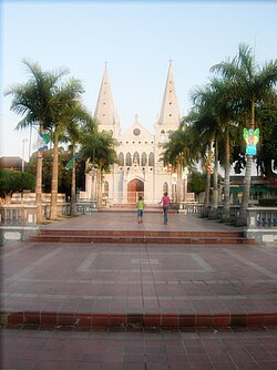
Turbaco is a municipality in the Bolívar Department of Colombia. It is located about 20 km southeast of Cartagena de Indias and is one of Bolívar's most organized municipalities. Turbaco is known for its famous "Fiesta de Toros" (Bulls's feast) in December to celebrate the new year.[3] Currently, the municipality is undergoing major expansion plans and remodeling.
Turbaco | |
|---|---|
Municipality and town | |
 Turbaco Plaza, Church of Santa Catalina | |
| Nickname: Los Tira Piedra | |
 Location of the municipality and town of Turbaco in the Bolívar Department of Colombia | |
| Coordinates: 10°19′N 75°26′W / 10.317°N 75.433°W | |
| Country | |
| Department | Bolívar Department |
| Government | |
| • Mayor | Guillermo Torres[1] |
| Area | |
• Municipality and town | 202 km2 (78 sq mi) |
| • Urban | 13.92 km2 (5.37 sq mi) |
| Elevation | 128 m (420 ft) |
| Population (2018 census)[2] | |
• Municipality and town | 105,166 |
| • Density | 520/km2 (1,300/sq mi) |
| • Urban | 97,294 |
| • Urban density | 7,000/km2 (18,000/sq mi) |
| Demonym | Turbaquero |
| Time zone | UTC-5 (Colombia Standard Time) |
| Area code | 57 + 5 |
| Website | Official website (in Spanish) |
Juan de la Cosa was mortally wounded here in 1510, before Pedro de Heredia subjugated the area in 1533.[4][5]
Antonio López de Santa Anna spent some of his exile years here, 1850–1853 and 1855–1857.[6]
References
edit- ^ "Yesterday, he sang for guerrillas. Today, he's one town's mayor". The Christian Science Monitor.
- ^ Citypopulation.de Population of Turbaco municipality with localities
- ^ "Corralejas: ¿fiesta o barbarie?". Corralejas ¿fiesta o barbarie?.
- ^ Parry, John; Keith, Robert (1984). New Iberian World: A Documentary History of the Discovery and Settlement of Latin America to the Early 17th Century, Vol. II. New York: Times Books. p. 454,479–485. ISBN 9780812910704.
- ^ Floyd, Troy (1973). The Columbus Dynasty in the Caribbean, 1492-1526. Albuquerque: University of New Mexico Press. pp. 49, 89, 95, 135.
- ^ Lemaitre, Eduardo (1994). A Brief History of Cartagena. Medellin: Compania Litografica Nacional S.A. p. 13,75. ISBN 9789586380928.
10°21′N 75°20′W / 10.350°N 75.333°W

