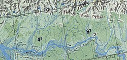
The Tukulan (Russian: Тукулаан; Yakut: Тукулан) is a river in the Sakha Republic (Yakutia), Russia, a right tributary of the Aldan, part of the Lena basin.
| Tukulan Тукулан | |
|---|---|
 Sordogin Range and course of the Tukulan | |
Mouth location in Yakutia, Russia | |
| Location | |
| Country | Russian Federation |
| Physical characteristics | |
| Source | Lake Ulakhan-Kyuel, Verkhoyansk Range |
| Mouth | Aldan River |
• coordinates | 63°19′0.26″N 131°55′31.69″E / 63.3167389°N 131.9254694°E |
| Length | 191 km (119 mi) |
| Basin size | 2,880 km2 (1,110 sq mi) |
| Basin features | |
| Progression | Aldan→ Lena→ Laptev Sea |
The Tukulan has a length of 191 kilometres (119 mi) and a drainage basin area of 2,880 square kilometres (1,110 sq mi).[1] There are no settlements in the area of the river. The nearest inhabited places are Batamay of Kobyaysky District to the west of the Tukulan's mouth and Udarnik, Krest-Khaldzhay and Ary-Tolon of Tompo District to the east.[2]
Course
editThe Tukulan originates in Lake Ulakhan-Kyuel, a 1.5 km2 (0.58 sq mi) mountain lake of the southwestern Verkhoyansk Range located in Ust-Aldan District. In the upper section of its course the river flows across mountainous terrain, heading roughly southwestwards across the Sordogin Range.[3][4]
After leaving the mountainous area the Tukulan flows approximately in the same SW direction along its middle course. It crosses a floodplain dotted with about 200 lakes where the riverbed divides into slowly-flowing arms. Its lower course is a vast marshy area. Finally the Tukulan meets the right bank of the Aldan River, a little upstream from the mouth of the Kele and downstream of the Baray, 148 km (92 mi) from the confluence of the Aldan with the Lena.[5][3][6] The river freezes between mid October and mid May.[4]
The Tukulan's main tributary is the 98 km (61 mi) long Tuora Tukulan joining it from the right side.[4]
See also
editReferences
edit- ^ "Река Тукулаан in the State Water Register of Russia". textual.ru (in Russian).
- ^ Google Earth
- ^ a b 1,000,000 scale Operational Navigation Chart; Sheet D-7
- ^ a b c Nature.ykt
- ^ "P-51_52 Chart (in Russian)". Retrieved 29 August 2021.
- ^ Aldan - Water of Russia
