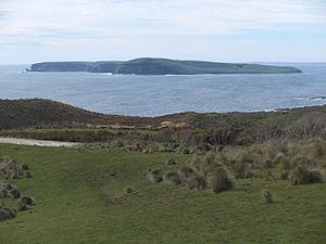
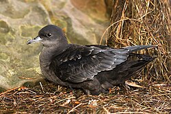
Trefoil Island (in palawa kani : Titima[1]), officially known as titima / Trefoil Island,[2] is an island with an area of 115.79 ha, in south-eastern Australia. It is part of Tasmania’s Trefoil Island Group, lying close to Cape Grim, Tasmania's most north-westerly point, in Bass Strait. It is owned by the Trefoil Island Aboriginal Cooperative and is home to an estimated 1.5 million breeding pairs of short-tailed shearwaters, which are subject to annual muttonbirding activities.[3] Approval is required to visit.


There is an airstrip, otherwise small boats can be used on calm days at Kelp Beach. The shoreline is covered with pebbly rocks.
Trefoil Island Group
editTrefoil Island Group consists of:
- Trefoil Island
- Harbour Islets
- Henderson Islets
- Little Trefoil Island
- Murkay Islets
- Seacrow Islet, aka Seacrow Island
- Shell Islets
- The Doughboys
Fauna and flora
editThe island forms part of the Hunter Island Group Important Bird Area.[4] Apart from the short-tailed shearwaters, breeding seabird and shorebird species include little penguin, Pacific gull, silver gull, sooty oystercatcher and pied oystercatcher. The Cape Barren goose also breeds on the island. Reptiles include metallic skink and the introduced tiger snake.[3]
The main vegetation is silver tussock Poa poiformis with a few small patches of bracken fern Pteridium esculentum. The only trees on Trefoil are six specimens of Cupressus macrocarpa.
The Kay Family Calamity
editIn 1895, the Kay family, who ran sheep on the island, visited the island. Albert Boyes Kay, his pregnant wife and two children attempted to return to the mainland but were thrown from the boat and drowned.[5]
The surviving six children watched from Trefoil island. Belinda Maud, Lydia May, Albert Boys, Jane Georgina, Wintena Alberta and Robert were now entirely alone on the inhospitable island. The eldest, Belinda, was just thirteen years old.[6]
The six siblings survived on Trefoil island for six weeks by killing livestock and keeping a rescue fire burning. They were saved by James Parker of the May Queen.[7]
References
edit- ^ "Ya pulingina. Bringing these words to life is an extension of our identity". TheGuardian.com. 2 September 2016.
- ^ "Survey Co-ordination" (PDF). Tasmanian Government Gazette: 157. 27 January 2016. Retrieved 2 March 2022.
- ^ a b Brothers, Nigel; Pemberton, David; Pryor, Helen; & Halley, Vanessa. (2001). Tasmania’s Offshore Islands: seabirds and other natural features. Tasmanian Museum and Art Gallery: Hobart. ISBN 0-7246-4816-X
- ^ BirdLife International. (2011). Important Bird Areas factsheet: Hunter Island Group. Downloaded from http://www.birdlife.org on 2011-07-09.
- ^ "A Sad Drowning Story. - HUSBAND AND WIFE AND TWO CHILDREN DROVNED NEAR CAPE GRIM. A PATHETIC NARRATIVE. - Wellington Times and Agricultural and Mining Gazette (Tas. : 1890 - 1897) - 30 Nov 1895". Wellington Times and Agricultural and Mining Gazette (Tas. : 1890 - 1897). 30 November 1895. p. 2. Retrieved 20 May 2017.
- ^ "A Sad Drowning Story. - HUSBAND AND WIFE AND TWO CHILDREN DROVNED NEAR CAPE GRIM. A PATHETIC NARRATIVE. - Wellington Times and Agricultural and Mining Gazette (Tas. : 1890 - 1897) - 30 Nov 1895". Wellington Times and Agricultural and Mining Gazette (Tas. : 1890 - 1897). 30 November 1895. p. 2. Retrieved 20 May 2017.
- ^ "TERRIBLE BOATING FATALITY. - PARENTS AND TWO CHILDREN DROWNED. STANLEY, FRIDAY; - Launceston Examiner (Tas. : 1842 - 1899) - 30 Nov 1895". Launceston Examiner (Tas. : 1842 - 1899). 30 November 1895. p. 7. Retrieved 20 May 2017.
40°38′S 144°41′E / 40.633°S 144.683°E