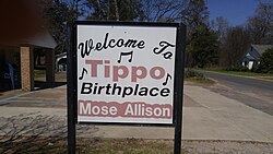
Tippo is an unincorporated community located in Tallahatchie County, Mississippi, United States, located approximately 10 miles (16 km) from Swan Lake; 11 miles (18 km) northeast of Glendora; and approximately 14 miles (23 km) from Charleston. Tippo is located at the intersection of Tippo and Sharkey roads.
Tippo, Mississippi | |
|---|---|
 | |
| Coordinates: 33°54′43″N 90°10′50″W / 33.91194°N 90.18056°W | |
| Country | United States |
| State | Mississippi |
| County | Tallahatchie |
| Elevation | 148 ft (45 m) |
| Time zone | UTC-6 (Central (CST)) |
| • Summer (DST) | UTC-5 (CDT) |
| ZIP code | 38962 |
| Area code | 662 |
| GNIS feature ID | 678774[1] |
Tippo has a post office with ZIP code 38962.[2]
The community is named after Tippo Bayou.[3]
Education
editTippo is in the East Tallahatchie School District.[4][5] Charleston High School is the area high school.
Coahoma Community College is the designated community college.[6]
Notable person
editGallery
edit-
Tippo Post Office
-
Tippo Volunteer Fire Department
-
Tippo United Methodist Church
-
Mississippi Blues Trail marker for Mose Allison
References
edit- ^ a b U.S. Geological Survey Geographic Names Information System: Tippo, Mississippi
- ^ "Free ZIP Code Lookup with area code, county, geocode, MSA/PMSA, population". www.zipinfo.com.
- ^ Baca, Keith A. (2007). Native American Place Names in Mississippi. University Press of Mississippi. p. 113. ISBN 978-1-60473-483-6.
- ^ "2020 CENSUS - SCHOOL DISTRICT REFERENCE MAP: Tallahatchie County, MS" (PDF). U.S. Census Bureau. Retrieved May 20, 2021.
- ^ "Tippo". Geographic Names Information System. United States Geological Survey, United States Department of the Interior.
- ^ "Student Residency" (Archive). Coahoma Community College. Retrieved on July 8, 2017. "Out-of-District Resident: A student who does not live within Bolivar, Coahoma, Quitman, Tallahatchie, and Tunica Counties but does live in some other county in Mississippi."
- ^ "Mose Allison". www.msbluestrail.org.

