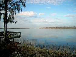
The Tensaw River is a river in Baldwin County, Alabama.
| Tensaw River | |
|---|---|
 The Tensaw River in Blakeley, Alabama | |
 | |
| Location | |
| Country | United States |
| State | Alabama |
| County | Baldwin County |
| Physical characteristics | |
| Source | |
| • coordinates | 31°04′05″N 87°57′47″W / 31.06795°N 87.96306°W |
| Mouth | |
• coordinates | 30°41′07″N 88°00′25″W / 30.68519°N 88.00695°W |
| Length | 41 miles (66 km) |
The name Tensaw is derived from the historic indigenous Taensa people.[1]
Overview
editIt is a distributary of the Mobile River, approximately 41 miles (66 km) long. It is formed as a bayou of the Mobile approximately 6 miles (9.7 km) south of the formation of the Mobile by the confluence of the Tombigbee and Alabama rivers, at 31°04′05″N 87°57′47″W / 31.06795°N 87.96306°W.
The Tensaw flows alongside the Mobile and Middle rivers, with the Tensaw being the easternmost flowing river. There are numerous back channels extending off the main channel into Baldwin County. It enters Mobile Bay at 30°41′07″N 88°00′25″W / 30.68519°N 88.00695°W, near Blakeley and Pinto islands and approximately 1.8 miles (2.9 km) east of downtown Mobile.[2]
See also
editReferences
edit- ^ Swanton, John Reed (1952). The Indian Tribes of North America. US Government Printing Office. p. 210. ISBN 978-0-8063-1730-4.
- ^ U.S. Geological Survey Geographic Names Information System: Tensaw River