St Nicholas (Welsh: Sain Nicolas) is a village situated in the Vale of Glamorgan, Wales. It lies 2 miles (3.2 km) west of Cardiff and 6 miles (9.6 km) east of Cowbridge. According to the 2021 census, the village had a population of 654 residents. St Nicholas forms part of the larger community of St Nicholas and Bonvilston.
St Nicholas
| |
|---|---|
 | |
 St Nicholas Location within the Vale of Glamorgan | |
| Area | 0.2450 km2 (0.0946 sq mi) |
| Population | 654 (2021 Census)[1] |
| • Density | 2,669/km2 (6,910/sq mi) |
| • Cardiff | 1.74 mi (2.8 km) |
| Principal area | |
| Preserved county | |
| Country | Wales |
| Sovereign state | United Kingdom |
| Post town | CARDIFF |
| Postcode district | CF5 |
| Dialling code | 01446, 02920 |
| Police | South Wales |
| Fire | South Wales |
| Ambulance | Welsh |
| UK Parliament | |
The village is bisected by the A48 road, with notable landmarks such as the parish church[2] and a primary school[3] situated to the north of the road. The surrounding area consists largely of agricultural fields and lies within the Dyffryn Basin and Ridge Slopes Special Landscape Area[4].
Amenities
editSt Nicholas has no shops or pubs; the nearest amenities can be found in the nearby villages of Bonvilston and Culverhouse Cross.
The village is located approximately a 15-minute drive from Cardiff city centre to the east[5] and a 10-minute drive from the market town of Cowbridge to the west[6]. It is also connected to Barry via the A4226, commonly known as Five Mile Lane, which branches off from the A48.
Public transport services the village through the X2 route, with eastbound destinations including Culverhouse Cross, Cardiff Bay, and Cardiff city centre, and westbound destinations such as Bonvilston, Cowbridge, Bridgend, and Porthcawl.
History
editEvidence of human settlement in St. Nicholas dates back to Neolithic times, with significant archaeological findings at Tinkinswood, located less than a mile to the south.
The modern village has evolved from an agricultural community, with land historically divided among three prominent families: the Earl of Pembroke, Miles Button of Dyffryn, and Rice Meyrick of Cottrell. This division is still reflected in the village's layout today.
During the 20th century, the village saw considerable development, particularly to the south by the Cardiff Rural District Council. The growth of Cardiff and the construction of the A4232 link road increased St. Nicholas's appeal as a commuter village.
On 6 October 2016, a controversial planning application by Redrow Homes was approved, permitting the construction of 100 new homes. An additional 17 homes were later included by Waterstone Homes, with construction beginning in the summer of 2017. The development effectively doubled the village's size. That same year, the village church hall was sold.
Gallery
edit-
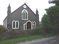 Presbyterian church
 -
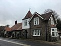
 The former pub, The Three Tuns
 -
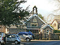 Primary school
 -
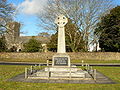 St Nicholas War Memorial
 -
 The former church hall, now Church Hall House and Tinkinswood Hall
 -
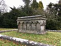 The Cory family tomb in St Nicholas churchyard
 -
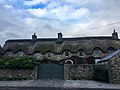
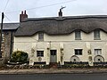 Smith's Row of thatched cottages


References
edit- ^ "St Nicholas (The Vale of Glamorgan, Wales / Cymru, United Kingdom) – Population Statistics, Charts, Map, Location, Weather and Web Information". www.citypopulation.de. Retrieved 29 December 2022.
- ^ "St Nicholas, St Nicholas - The Church in Wales". www.churchinwales.org.uk. Retrieved 6 September 2024.
- ^ "St Nicholas CIW Primary". www.valeofglamorgan.gov.uk. Retrieved 6 September 2024.
- ^ https://www.valeofglamorgan.gov.uk/Documents/Living/Planning/Policy/LDP/Background%20Papers/Special_Landscape_Areas_Integration_with_Adjoining_Local_Authorities_2008.pdf
- ^ https://www.openstreetmap.org/directions?engine=fossgis_osrm_car&route=51.46072%2C-3.31132%3B51.47980%2C-3.17686
- ^ https://www.openstreetmap.org/directions?engine=fossgis_osrm_car&route=51.46072%2C-3.31132%3B51.46169%2C-3.44727
External links
edit- St Nicholas Village Website
- St Nicholas Church in Wales Primary School
- Photos of St Nicholas and the surrounding area on geograph.org.uk
This Vale of Glamorgan location article is a stub. You can help Wikipedia by expanding it. |