You can help expand this article with text translated from the corresponding article in Spanish. (May 2012) Click [show] for important translation instructions.
|
Santiago de Chuco is a city in Peru, capital of Santiago de Chuco Province, La Libertad Region.
Santiago de Chuco | |
|---|---|
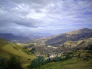
 Panoramic view of the city of Santiago de Chuco | |
| Coordinates: 8°9′0.78″S 78°10′41.95″W / 8.1502167°S 78.1783194°W | |
| Country | |
| Region | La Libertad Region |
| Province | Santiago de Chuco |
| Government | |
| • Mayor | Juan Gabriel Alipio |
| Elevation | 3,120 m (10,240 ft) |
| Population (2005) | |
| • Urban | 25 000 |
| • Demonym | Santiaguino(a) |
| Time zone | UTC-5 (PET) |
| Website | Municipality |
History
editOn July 23, 1553 it was obtained permission to found a town that served as the capital and hub of mining and wheat. Captain Don Diego de la Serna, immigrants Domingo Perez Vasquez, Jose Pelaez, Lino Benítes of Children, Miguel de Estremadura, Rodrigo of Bejarano, Fernando de Alva, Garcia de Paredes, Lorenzo de Alcantara, Juan Baptist father Ruiz and Francisco de Asis Centurion reached Andaymarca, a native of Santiago de Compostela, who helped Santiago the "greatest" be the tutelary patron of the new town.
Notable people
edit- César Vallejo
- Luis de la Puente Uceda
- Pablo Uceda
- Eladio Ruiz Cerna
Climate
edit| Climate data for Santiago de Chuco, elevation 3,115 m (10,220 ft) | |||||||||||||
|---|---|---|---|---|---|---|---|---|---|---|---|---|---|
| Month | Jan | Feb | Mar | Apr | May | Jun | Jul | Aug | Sep | Oct | Nov | Dec | Year |
| Mean daily maximum °C (°F) | 19.7 (67.5) |
18.8 (65.8) |
18.2 (64.8) |
18.6 (65.5) |
20.0 (68.0) |
20.3 (68.5) |
20.5 (68.9) |
20.7 (69.3) |
21.4 (70.5) |
20.3 (68.5) |
20.9 (69.6) |
20.1 (68.2) |
20.0 (67.9) |
| Mean daily minimum °C (°F) | 7.7 (45.9) |
8.4 (47.1) |
8.0 (46.4) |
8.0 (46.4) |
7.4 (45.3) |
7.0 (44.6) |
6.5 (43.7) |
7.3 (45.1) |
7.3 (45.1) |
7.9 (46.2) |
8.2 (46.8) |
7.8 (46.0) |
7.6 (45.7) |
| Average precipitation mm (inches) | 97.1 (3.82) |
121.3 (4.78) |
124.2 (4.89) |
79.9 (3.15) |
20.6 (0.81) |
6.5 (0.26) |
5.6 (0.22) |
4.0 (0.16) |
2.4 (0.09) |
35.6 (1.40) |
17.3 (0.68) |
31.5 (1.24) |
546 (21.5) |
| Source: Sistema Nacional de Información Ambiental[1] | |||||||||||||
See also
editReferences
edit- ^ ""La Libertad: Clima y Ríos en Cifras Estadísticas de Seis Décadas"" (PDF). Sistema Nacional de Información Ambiental. Archived from the original (PDF) on 8 June 2024. Retrieved 8 June 2024.
External links
edit- The information in this article is based on that in its Spanish equivalent.


