You can help expand this article with text translated from the corresponding article in French. (December 2018) Click [show] for important translation instructions.
|
Pohénégamook (French pronunciation: [pɔeneɡamok]; pop. 2481) is a Canadian town on the Canada–United States border in Quebec's Témiscouata Regional County Municipality.
Pohénégamook | |
|---|---|
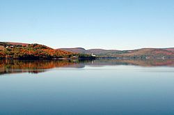
 Pohenegamook Lake | |
 Location within Témiscouata RCM | |
| Coordinates: 47°28′N 69°13′W / 47.467°N 69.217°W[1] | |
| Country | |
| Province | |
| Region | Bas-Saint-Laurent |
| RCM | Témiscouata |
| Constituted | November 3, 1973 |
| Government | |
| • Mayor | Benoît Morin |
| • Federal riding | Rimouski-Neigette— Témiscouata—Les Basques |
| • Prov. riding | Rivière-du-Loup-Témiscouata |
| Area | |
• Total | 349.40 km2 (134.90 sq mi) |
| • Land | 339.99 km2 (131.27 sq mi) |
| Population | |
• Total | 2,481 |
| • Density | 7.3/km2 (19/sq mi) |
| • Pop 2016-2021 | |
| • Dwellings | 1,393 |
| Time zone | UTC−5 (EST) |
| • Summer (DST) | UTC−4 (EDT) |
| Postal code(s) | |
| Area code(s) | 418 and 581 |
| Highways | |
| Website | www |
The town shares the border with Estcourt Station, Maine, the northernmost point in New England.
As of 2021, Pohénégamook had 2,481 people, down 3.9% from the last census in 2016.
The town is named after Lake Pohenegamook and is located on the lake's southern and western shores.
History
editPohénégamook was amalgamated with the formerly-independent communities of Saint-Pierre d'Estcourt, Saint-Éleuthère, Village-Blier and Saint-David-de-Sully on October 23, 1973.
Demographics
editIn the 2021 Census of Population conducted by Statistics Canada, Pohénégamook had a population of 2,481 living in 1,171 of its 1,393 total private dwellings, a change of -3.9% from its 2016 population of 2,582. With a land area of 339.99 km2 (131.27 sq mi), it had a population density of 7.3/km2 (18.9/sq mi) in 2021.[4]
| Year | Pop. | ±% |
|---|---|---|
| 1976 | 3,627 | — |
| 1981 | 3,702 | +2.1% |
| 1986 | 3,526 | −4.8% |
| 1991 | 3,248 | −7.9% |
| 1996 | 3,259 | +0.3% |
| 2001 | 3,097 | −5.0% |
| 2006 | 2,940 | −5.1% |
| 2011 | 2,770 | −5.8% |
| 2016 | 2,585 | −6.7% |
| 2021 | 2,481 | −4.0% |
Attractions
editParc de la Frontière,[6] located along the southern lakeshore of Lake Pohenegamook, straddles the U.S.-Canadian border. It features a historic marker[7] and gives visitors the experience of visiting a park in two countries.
See also
edit- Lake Pohenegamook, a waterbody
- Boucanée River, a stream
- List of cities in Quebec
References
edit- ^ "Banque de noms de lieux du Québec: Reference number 50039". toponymie.gouv.qc.ca (in French). Commission de toponymie du Québec.
- ^ a b "Répertoire des municipalités: Geographic code 13095". www.mamh.gouv.qc.ca (in French). Ministère des Affaires municipales et de l'Habitation.
- ^ a b "Census Profile, 2021 Census, Statistics Canada - Validation Error".
- ^ "Population and dwelling counts: Canada, provinces and territories, and census subdivisions (municipalities), Quebec". Statistics Canada. February 9, 2022. Retrieved August 29, 2022.
- ^ Statistics Canada: 1996, 2001, 2006, 2011, 2016, 2021 census
- ^ "Parc de la Frontière - Pohénégamook | Regional parks - Bas-Saint-Laurent".
- ^ "Le Pont International / The International Bridge Historical Marker".
External links
edit- Media related to Pohénégamook at Wikimedia Commons
- http://www.pohenegamook.net (Pohenegamook official website)
