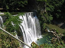
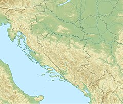
The Pliva Waterfall (Serbian Cyrillic: Пливски водопад) is located by the town of Jajce, in central Bosnia and Herzegovina, where the river Pliva meets the river Vrbas. The waterfall is a large tufa, also known as travertine barrier, making over 22 meters cascade on the Pliva river, in a narrow karstic zone, which follows the Pliva course, retracted into a flysh and limestone contact zone. It was 30 meters high, but after an earthquake during the Bosnian war and attacks on the power plant further up the river, the area was flooded and now the waterfall is 22 meters high.
| Pliva Waterfall | |
|---|---|
| Jajce Waterfall | |
 Waterfall on the Pliva river, in Jajce, Bosnia | |
 | |
| Location | Jajce, Bosnia and Herzegovina |
| Coordinates | 44°20′16″N 17°16′14″E / 44.3377°N 17.2706°E |
| Type | Segmented |
| Elevation | 1,000 m (3,300 ft) |
| Total height | 22 m (72 ft) |
| Number of drops | 1 |
| Longest drop | 30 m (98 ft) |
| Average width | 30 m (98 ft) |
| Watercourse | Pliva river |
| Average flow rate | 3 m3/s (110 cu ft/s) |
The old Jajce walled city core, including the waterfall, and other individual sites outside the walled city perimeter, such as the Jajce Mithraeum, is designated as The natural and architectural ensemble of Jajce and proposed for inscription into the UNESCO's World Heritage Site list. The bid for inscription is currently placed on the UNESCO Tentative list.[1][2]
Scenery
edit-
River Pliva near Jajce, in central Bosnia, some 100 meters upstream from the waterfall
-
Upstream one can find several more smaller waterfalls
-
Watermills 4 km upstream
References
edit- ^ "The natural and architectural ensemble of Jajce – UNESCO World Heritage Centre". UNESCO World Heritage Centre. Archived from the original on 10 January 2018. Retrieved 25 December 2017.
- ^ "UNESCO World Heritage Centre – Tentative Lists: Bosnia and Herzegovina". UNESCO World Heritage Centre. Archived from the original on 16 July 2017. Retrieved 25 July 2017.

