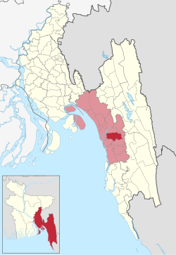
Patiya (Bengali: পটিয়া) is an upazila of Chattogram District in Chattogram Division, Bangladesh.
Patiya
পটিয়া | |
|---|---|
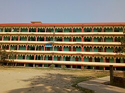
 Buildings of Shahchand Auliya Kamil Madrash | |
 | |
| Coordinates: 22°18′N 91°59′E / 22.300°N 91.983°E | |
| Country | |
| Division | Chittagong |
| District | Chittagong |
| Jatiya Sangsad constituency | Chittagong-12 |
| Headquarters | Patiya Upazila Complex |
| Government | |
| • Body | Upazila Council |
| • MP | Vacant |
| • Chairman | Dr. Timir Baran Chowdhury (Acting) |
| Area | |
• Total | 156.34 km2 (60.36 sq mi) |
| Population | |
• Total | 397,679 |
| • Density | 2,500/km2 (6,600/sq mi) |
| Time zone | UTC+6 (BST) |
| Postal code | 4370[2] |
| Area code | 03035[3] |
| Website | patiya.gov.bd |
History
editDuring the British rule, a police station(thana) was established in Patiya in 1845. It was upgraded to an upazila in 1984. The region saw revolutionary activities in the 1930s, when revolutionaries from Jugantar and the fugitives of the Chittagong armoury raid fought with British police. During the Bangladesh Liberation War, the area sustained heavy bombings from Pakistan Air Force.[4] The Pakistani occupation army massacred more than 300 Hindus in Muzaffarabad village on 3 May 1971 in collaboration with the Razakars.
Geography
editPatiya is located at 22°18′00″N 91°59′00″E / 22.3000°N 91.9833°E. It has 71,624 households and a total area of 316.47 km2 (122.19 sq mi).
The township of Patiya has an area of 9.96 km2 (3.85 sq mi).
"Budbudir Chora" is one of them having enormous green forest and wild life. Every year local tourists go there for its green forest, small canals and animals like deer, birds and butterflies.
Demographics
editAs of the 2011 Census of Bangladesh, Patiya upazila had 71,624 households and a population of 366,010. 52,611 (14.37%) were under 7 years of age. Patiya had an average literacy rate of 56.17%, compared to the national average of 51.8%, and a sex ratio of 1006 females per 1000 males. 55,323 (15.12%) of the population lived in urban areas.[6][7]
According to the 1991 Bangladesh census, Patiya had a population of 398,836. Males constituted 52.1% of the population, and females 47.9%. The population aged 18 or over was 197,399. Patiya had an average literacy rate of 44.3% (7+ years), against the national average of 32.4%.[8]
Administration
editPatiya Upazila is divided into Patiya Municipality and 22 union parishads: Asia, Bara Uthan, Baralia, Bhatikhain, Chanhara, Char Lakshya, Char Patharghata, Dakshin Bhurshi, Dhalghat, Habilasdwip, Haidgaon, Janglukhain, Jiri, Juldha, Kachuai, Kasiais, Kelishahar, Kharana, Kolagaon, Kusumpura, Sikalbaha, and Sobhandandi. The union parishads are subdivided into 113 mauzas and 208 villages.[9]
Patiya Municipality is subdivided into 9 wards and 13 mahallas.[9]
Chairman: Vacant
Vice Chairman: Vacant
Woman Vice Chairman:Vacant
Upazila Nirbahi Officer (UNO): Abdullah Al Mamun
Patiya Municipal Mayor: Vacant
Education
editAccording to Banglapedia, Abdur Rahman Government Girls' High School, founded in 1957, Abdus Sobhan Rahat Ali High School (1914), Chakrashala Krishi High School (1857), Muzaffarabad N. J. High School (1929), S A Noor High School (1966), Union Krishi High School (1978), Jangal Khain High School (1946) and Patiya Model High School (1845) are notable secondary schools.[4]
The madrasa education system includes a notable kamil madrasa, Shahchand Auliya Kamil Madrasa, founded in 1928.[4]
Notable residents
edit- Purnendu Dastidar, revolutionary politician and writer, was born in Dhalghat village in 1909.[10]
- Maniruzzaman Islamabadi, Islamic philosopher and journalist, was from Barama village.[11]
- Pritilata Waddedar, revolutionary nationalist, was born at Dhalghat village in 1911.[12]
- Ayub Bachchu, a Bangladeshi musician.
See also
editReferences
edit- ^ National Report (PDF). Population and Housing Census 2022. Vol. 1. Dhaka: Bangladesh Bureau of Statistics. November 2023. p. 396. ISBN 978-9844752016.
- ^ "Bangladesh Postal Code". Dhaka: Bangladesh Postal Department under the Department of Posts and Telecommunications of the Ministry of Posts, Telecommunications and Information Technology of the People's Republic of Bangladesh. 20 October 2024.
- ^ "Bangladesh Area Code". China: Chahaoba.com. 18 October 2024.
- ^ a b c Jahangir, SMAK (2012). "Patiya Upazila". In Islam, Sirajul; Jamal, Ahmed A. (eds.). Banglapedia: National Encyclopedia of Bangladesh (Second ed.). Asiatic Society of Bangladesh.
- ^ Population and Housing Census 2022 - District Report: Chattogram (PDF). District Series. Dhaka: Bangladesh Bureau of Statistics. June 2024. ISBN 978-984-475-247-4.
- ^ "Bangladesh Population and Housing Census 2011 Zila Report – Chittagong" (PDF). bbs.gov.bd. Bangladesh Bureau of Statistics.
- ^ "Community Tables: Chittagong district" (PDF). bbs.gov.bd. Bangladesh Bureau of Statistics. 2011.
- ^ "Population Census Wing, BBS". Archived from the original on 27 March 2005. Retrieved 10 November 2006.
- ^ a b "District Statistics 2011: Chittagong" (PDF). Bangladesh Bureau of Statistics. Archived from the original (PDF) on 13 November 2014. Retrieved 14 July 2014.
- ^ Bhuiyan, Golam Kibria (2012). "Dastidar, Purnendu". In Islam, Sirajul; Jamal, Ahmed A. (eds.). Banglapedia: National Encyclopedia of Bangladesh (Second ed.). Asiatic Society of Bangladesh.
- ^ Rizvi, S.N.H., ed. (1970). East Pakistan District Gazetteers: Chittagong (PDF). Government of East Pakistan Services and General Administration Department. p. 353. Archived from the original (PDF) on 20 December 2016. Retrieved 6 February 2018.
- ^ "Pritilata's birth anniversary observed at CU". New Age. 2012. Archived from the original on 29 January 2013.