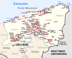
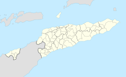
Pante Macassar (Portuguese: Pante Macassar, Tetum: Pante-Makassár, Indonesian: Pante Makassar) is a city in the Pante Macassar administrative post on the north coast of East Timor, 152 kilometres or 94 miles to the west of Dili, the nation's capital. It has a population of 4,730 (Stand 2006). It is the capital of the Oecusse exclave (former Oecussi-Ambeno).
Pante Macassar
Oecussi Vila Taveiro | |
|---|---|
City | |
 | |
| Coordinates: 9°12′S 124°23′E / 9.200°S 124.383°E | |
| Country | |
| Municipality | |
| Administrative post | Pante Macassar |
| Area | |
| • Total | 357.30 km2 (137.95 sq mi) |
| Elevation | 189 m (620 ft) |
| Population (2015 census) | |
| • Total | 12,352 |
| • Density | 35/km2 (90/sq mi) |
| Time zone | UTC+09:00 (TLT) |
| Climate | Aw |

Name
editThe name literally means "beach of Makassar", alluding to the erstwhile trade with Makassar in Sulawesi (South Celebes), named by settlers who settled here seasonally in earlier centuries while waiting for the right winds to return home.[1] Locally Pante Macassar is known also as "Oecussi," which is commonly translated as "water pot",[1] and was the name of one of the two original kingdoms that form the exclave. The other was Ambeno. During the Portuguese colonisation, the city was also known as Vila Taveiro.
Geography
editPante Macassar is located on the Sawu Sea in Suco Costa, 281 km west of Dili, near the north coast of the island, at an altitude of 189 metres above sea level.[2] It consists of a series of loosely connected hamlets that reach as far west as the Tono River, which spans the Noefefan Bridge.
History
editOn the coast near Pante Macassar lies Oesono, where the Kingdom of Oecussi had its seat.[3] The kingdom was ruled by Topasses. The Topasses were descendants of Portuguese soldiers, sailors and traders who married women from Solor. They had a decisive influence on developments on Timor in the 17th and 18th centuries.[4] 6 kilometres west of the present-day town of Pante Macassar, Dominicans founded the town of Lifau in 1556 to secure the sandalwood trade. From 1702 onwards, Lifau, in the outskirts of the present city, was the place where the Portuguese first disembarked on Timor and was the first capital of Portuguese Timor. It continued as capital until 1769, when that was transferred to Dili because of constant attacks from the Topasses.
In May 1912, during the great Manufahi rebellion, there was also an uprising against the colonial rulers in Oecussi. The rebellion was put down with the support of the gunboat Pátria.[4]
In the turmoil of the last months of Portuguese rule over East Timor, Due to its distance from the remainder of East Timor, Oecussi-Ambeno, and specifically Pante Macassar, became the first territory occupied by Indonesia on 29 November 1975. Indonesia occupied Oe-Cusse Ambeno as early as 6 June 1975. When Fretilin finally declared East Timor independent from Portugal on 28 November 1975, the Indonesian flag was planted in Pante Macassar the following day. The invasion of the rest of East Timor began on 7 December 1975.
During the 1999 East Timorese crisis, which followed the independence referendum, Pante Macassar was targeted by pro-Indonesian militias, supported by the Indonesian military. 65 civilians who supported independence were hanged, and most of Pante Macassar was burned to the ground, except for two churches.[5]
Twice a week, a ferry boat from Dili arrives, for a journey that takes 12 hours (which is half a day).
Climate
editAs is typical of the north coast of Timor, Pante Macassar has a tropical savanna climate (Köppen Aw) with a wet season from December to March and a long dry season from April to November.
| Climate data for Pante Macassar | |||||||||||||
|---|---|---|---|---|---|---|---|---|---|---|---|---|---|
| Month | Jan | Feb | Mar | Apr | May | Jun | Jul | Aug | Sep | Oct | Nov | Dec | Year |
| Mean daily maximum °C (°F) | 29.9 (85.8) |
29.4 (84.9) |
29.9 (85.8) |
30.7 (87.3) |
30.9 (87.6) |
30.4 (86.7) |
29.8 (85.6) |
29.6 (85.3) |
29.6 (85.3) |
30.0 (86.0) |
30.7 (87.3) |
30.3 (86.5) |
30.1 (86.2) |
| Daily mean °C (°F) | 27.3 (81.1) |
26.6 (79.9) |
26.6 (79.9) |
26.9 (80.4) |
26.9 (80.4) |
26.2 (79.2) |
25.3 (77.5) |
25.0 (77.0) |
25.2 (77.4) |
26.3 (79.3) |
27.7 (81.9) |
27.7 (81.9) |
26.5 (79.7) |
| Mean daily minimum °C (°F) | 24.7 (76.5) |
23.8 (74.8) |
23.4 (74.1) |
23.1 (73.6) |
22.9 (73.2) |
22.0 (71.6) |
20.8 (69.4) |
20.5 (68.9) |
20.9 (69.6) |
22.6 (72.7) |
24.8 (76.6) |
25.1 (77.2) |
22.9 (73.2) |
| Average rainfall mm (inches) | 260 (10.2) |
214 (8.4) |
150 (5.9) |
57 (2.2) |
37 (1.5) |
18 (0.7) |
17 (0.7) |
7 (0.3) |
1 (0.0) |
12 (0.5) |
48 (1.9) |
167 (6.6) |
988 (38.9) |
| Source: Climate-Data.org[6] | |||||||||||||
References
edit- ^ a b Hull, Geoffrey (2002), The Languages of East Timor: Some Basic Facts (Revised 9.2.2002) (PDF), Independently published, archived from the original (PDF) on 1 October 2009, retrieved 20 April 2022
- ^ "Directory of Cities and Towns in East Timor". www.fallingrain.com. Retrieved 11 November 2023.
- ^ Hull, Geoffrey (2002). "The Languages of East Timor - Some Basic Facts" (PDF). Universidade Nacional Timor Lorosa'e. Archived from the original (PDF) on 1 October 2009.
- ^ a b "History of Timor" (PDF). Technical University of Lisbon. Archived from the original (PDF) on 24 March 2009.
- ^ "CAVR-Report: Chapter 7.3: Forced Displacement and Famine" (PDF). CAVR. Archived from the original (PDF) on 28 November 2015. Retrieved 11 November 2023.
- ^ "Climate: Pante Macassar". Climate-Data.org. Retrieved 16 April 2020.
Further reading
edit- Ministry of Infrastructure (September 2011). TIM: District Capitals Water Supply Project – The Expansion, Rehabilitation and Operation and Maintenance of Pante Macasar Water Supply Systems – Initial Environmental Examination (PDF) (Report). Asian Development Bank. District Capitals Water Supply Project (RRP TIM 44130-02). Retrieved 14 July 2022.
External links
editMedia related to Pante Macassar Vila at Wikimedia Commons
