Oshnavieh County (Persian: شهرستان اشنویه)[a] is in West Azerbaijan province, Iran. Its capital is the city of Oshnavieh.[3]
Oshnavieh County
Persian: شهرستان اشنویه | |
|---|---|
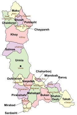
 Location of Oshnavieh County in West Azerbaijan province (center left, yellow) | |
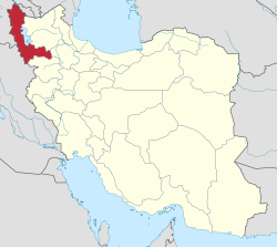
 Location of West Azerbaijan province in Iran | |
| Coordinates: 37°04′N 45°05′E / 37.067°N 45.083°E[1] | |
| Country | Iran |
| Province | West Azerbaijan |
| Capital | Oshnavieh |
| Districts | Central, Nalus |
| Population (2016)[2] | |
• Total | 73,886 |
| Time zone | UTC+3:30 (IRST) |
| Oshnavieh County can be found at GEOnet Names Server, at this link, by opening the Advanced Search box, entering "9205904" in the "Unique Feature Id" form, and clicking on "Search Database". | |
History
editDuring Iran-Iraq war, Ba'athist Iraq regime bombarded some parts of Oshnavieh in West Azerbaijan province (on 2 August 1988) by Chemical bombs;[4][5] and about 2700 persons were injured as a result of that.[6]
Demographics
editPopulation
editAt the time of the 2006 National Census, the county's population was 63,798 in 12,998 households.[7] The following census in 2011 counted 70,030 people in 17,778 households.[8] The 2016 census measured the population of the county as 73,886 in 19,336 households.[2]
Administrative divisions
editOshnavieh County's population history and administrative structure over three consecutive censuses are shown in the following table.
| Administrative Divisions | 2006[7] | 2011[8] | 2016[2] |
|---|---|---|---|
| Central District | 48,482 | 54,023 | 57,628 |
| Dasht-e Bil RD | 8,271 | 9,096 | 9,178 |
| Oshnavieh-ye Shomali RD | 10,315 | 12,204 | 8,649 |
| Oshnavieh (city) | 29,896 | 32,723 | 39,801 |
| Nalus District | 15,316 | 16,007 | 16,258 |
| Haq RD | 8,556 | 8,824 | 9,168 |
| Oshnavieh-ye Jonubi RD[b] | 4,272 | 4,245 | 4,117 |
| Nalus (city) | 2,488 | 2,938 | 2,973 |
| Total | 63,798 | 70,030 | 73,886 |
| RD = Rural District | |||
Geography
editThe county lies west of Lake Urmia about 1,300 metres above sea level, on the border with the Kurdish provinces of Iraq. The county is surrounded by high mountains which remain cool even at the height of summer.
See also
editMedia related to Oshnavieh County at Wikimedia Commons
Notes
edit- ^ Kurdish: 'اشنۆ'شنۆ'شنه
- ^ Formerly Godar Rural District[9]
References
edit- ^ OpenStreetMap contributors (27 September 2024). "Oshnavieh County" (Map). OpenStreetMap (in Persian). Retrieved 27 September 2024.
- ^ a b c Census of the Islamic Republic of Iran, 1395 (2016): West Azerbaijan Province. amar.org.ir (Report) (in Persian). The Statistical Center of Iran. Archived from the original (Excel) on 30 August 2022. Retrieved 19 December 2022.
- ^ "Anniversary of Oshnavieh bombard". tabnak.ir. Retrieved 11 June 2019.
- ^ "Oshanavieh chemical attack". yjc.ir. Retrieved 23 June 2019.
- ^ "Oshnavieh bombard". farsnews.ir. Retrieved 11 June 2019.
- ^ a b Census of the Islamic Republic of Iran, 1385 (2006): West Azerbaijan Province. amar.org.ir (Report) (in Persian). The Statistical Center of Iran. Archived from the original (Excel) on 20 September 2011. Retrieved 25 September 2022.
- ^ a b Census of the Islamic Republic of Iran, 1390 (2011): West Azerbaijan Province. irandataportal.syr.edu (Report) (in Persian). The Statistical Center of Iran. Archived from the original (Excel) on 20 January 2023. Retrieved 19 December 2022 – via Iran Data Portal, Syracuse University.
- ^ Habibi, Hassan (c. 2024) [Approved 26 February 1369]. Approval of reforms in the rural districts of West Azerbaijan province. lamtakam.com (Report) (in Persian). Ministry of Interior, Defense Political Commission of the Government Council. Proposal 14034.1.5.53; Notification 40154/T42K. Archived from the original on 18 February 2024. Retrieved 18 February 2024 – via Lam ta Kam.