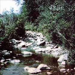
Oriskany Creek is a 33-mile-long (53 km)[2] river in New York, United States. It rises in Madison County and flows northeastward, primarily through Oneida County.[1] Oriskany Creek is a tributary of the Mohawk River and therefore part of the Hudson River watershed.
| Oriskany Creek | |
|---|---|
 The site of a patriot ambush during the Battle of Oriskany at Oriskany Creek | |
| Location | |
| Country | United States |
| State | New York |
| Counties | Madison, Oneida |
| Physical characteristics | |
| Source | |
| • location | Stockbridge, Madison County |
| • coordinates | 42°57′36″N 75°33′17″W / 42.96000°N 75.55472°W[1] |
| Mouth | Mohawk River |
• location | Whitestown, Oneida County |
• coordinates | 43°09′50″N 75°19′26″W / 43.16389°N 75.32389°W[1] |
| Length | 33 mi (53 km)[2] |
| Basin features | |
| Tributaries | |
| • left | Deans Creek |
| • right | White Creek, Turkey Creek, Big Creek, Buckley Mill Creek |
Oriskany Creek is wide and shallow, affording passage to only canoes, and that for only part of its length. The creek is known for its brown trout, which are caught from the shore or by wading.
History
editThe Oneida village of Oriskany was located near the mouth of the creek, by the Mohawk River.
During the American Revolutionary War, part of the Battle of Oriskany was fought in a swampy, steep ravine, near the mouth of the river.
When settlers arrived, the creek became the power source of many mills along its course.
The creek was an important source of water for the former Chenango Canal, which linked the Southern Tier of New York to the Erie Canal.
Communities along the creek
edit- Clark Mills
- Clinton
- Colemans Mills
- Deansboro
- Farmers Mills
- Kirkland
- Oriskany
- Oriskany Falls
- Solsville
- Walesville
See also
editReferences
edit- ^ a b c "Oriskany Creek". Geographic Names Information System. United States Geological Survey, United States Department of the Interior. Retrieved April 23, 2016.
- ^ a b U.S. Geological Survey. National Hydrography Dataset high-resolution flowline data. The National Map Archived 2012-03-29 at the Wayback Machine, accessed October 3, 2011

