This article's factual accuracy may be compromised due to out-of-date information. (October 2018) |
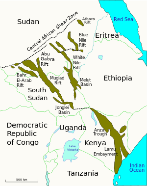
The Muglad Basin is a large rift basin in Northern Africa. The basin is situated within southern Sudan and South Sudan, and it covers an area of approximately 120,000 square kilometres (46,000 sq mi) across the two nations. It contains a number of hydrocarbon accumulations of various sizes, the largest of which are the Heglig and Unity oil fields.[1] During the 1960s and 1970s, Chevron made the first oil discoveries in the basin near the towns of Bentiu, Malakal, and Muglad.[2] Taken together, the Muglad and Melut rift basins account for the majority of Sudan's known oil reserves.[3]

The oil fields of the Muglad Basin are connected to Port Sudan on the Red Sea by the Greater Nile Oil Pipeline which begins at the Unity oil field.[4] Oil extracted in Muglad is known as "Nile Blend" crude. It is refined at Khartoum for export and domestic consumption.[5] Further oil exploration in the Muglad Basin commenced in February 2008.[6]
See also
edit- Economy of Sudan
- Greater Nile Oil Pipeline – Oil pipelime in South Sudan and Sudan
- Melut Basin – Rift basin in South Sudan
References
edit- ^ "Sudan - Muglad Basin". NPA Satellite Mapping. Archived from the original on 17 May 2008. Retrieved 21 August 2020.
- ^ Anon 2005, 'Focus on diplomacy and Sudan', APS Diplomat News Service, 15 August. Retrieved on 6 March 2008. (See discussion page.)
- ^ "Sudan Energy Data". Energy Information Administration. Archived from the original on 13 March 2008. Retrieved 21 August 2020.
- ^ USAID 2001, 'Sudan: Oil and gas concession holders' (map), University of Texas Library. Retrieved on 5 March 2008. (See discussion page.)
- ^ APS Review Downstream Trends 2007, 'SUDAN: The oil sector', www.entrepreneur.com, 29 October. Retrieved on 5 March 2008.
- ^ IHS 2008, 'WNPOC starts Muglad Basin drilling campaign - Sudan', www.ihs.com, 21 February. Retrieved on 5 March 2008.
External links
edit