Metlili (Arabic: متليلي) is a town and commune, and capital of Métlili District, in Ghardaïa Province, Algeria. According to the 2008 census it has a population of 40,576,[1] up from 33,759 in 1998,[2] and an annual growth rate of 1.9%.[1]
Metlili
متليلي | |
|---|---|
Commune and town | |
 Metlili | |
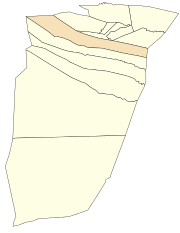
 Location of Metlili commune within Ghardaïa Province | |
| Coordinates: 32°16′22″N 3°37′39″E / 32.27278°N 3.62750°E | |
| Country | |
| Province | Ghardaïa Province |
| District | Métlili District |
| Area | |
• Total | 7,300 km2 (2,800 sq mi) |
| Elevation | 500 m (1,600 ft) |
| Population (2008)[1] | |
• Total | 40,576 |
| Time zone | UTC+1 (CET) |
The population is called Chaanbas (الشعانبة). They descend from the Banu Sulaym Arab tribe. They migrated from Arabia (south of Medina) along with the Banu Hilal tribe in the year 975 AD to Northern Egypt and then in about 1051 AD to north Africa: Libya, Tunisia, Algeria, Morocco.
Geography
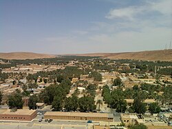
editMetlili lies at an elevation of about 500 metres (1,600 ft) in a valley running from northwest to southeast between arid, rocky hills. The town is about 12 kilometres (7.5 mi) from end to end, but only about 0.5 kilometres (0.31 mi) wide.
Climate
editMetlili has a hot desert climate (Köppen climate classification BWh), with very hot summers and mild winters, and very little precipitation throughout the year.
| Climate data for Metlili | |||||||||||||
|---|---|---|---|---|---|---|---|---|---|---|---|---|---|
| Month | Jan | Feb | Mar | Apr | May | Jun | Jul | Aug | Sep | Oct | Nov | Dec | Year |
| Mean daily maximum °C (°F) | 16.3 (61.3) |
19.0 (66.2) |
22.6 (72.7) |
28.1 (82.6) |
32.9 (91.2) |
38.5 (101.3) |
42.6 (108.7) |
41.6 (106.9) |
35.3 (95.5) |
28.0 (82.4) |
20.8 (69.4) |
16.9 (62.4) |
28.6 (83.4) |
| Daily mean °C (°F) | 10.1 (50.2) |
12.3 (54.1) |
15.7 (60.3) |
20.2 (68.4) |
24.9 (76.8) |
30.2 (86.4) |
33.8 (92.8) |
33.0 (91.4) |
28.2 (82.8) |
21.2 (70.2) |
14.6 (58.3) |
10.7 (51.3) |
21.2 (70.3) |
| Mean daily minimum °C (°F) | 4.0 (39.2) |
5.7 (42.3) |
8.8 (47.8) |
12.4 (54.3) |
16.9 (62.4) |
22.0 (71.6) |
25.0 (77.0) |
24.5 (76.1) |
21.1 (70.0) |
14.4 (57.9) |
8.5 (47.3) |
4.6 (40.3) |
14.0 (57.2) |
| Average precipitation mm (inches) | 7 (0.3) |
4 (0.2) |
10 (0.4) |
6 (0.2) |
4 (0.2) |
2 (0.1) |
1 (0.0) |
2 (0.1) |
5 (0.2) |
6 (0.2) |
7 (0.3) |
7 (0.3) |
61 (2.5) |
| Source: climate-data.org[3] | |||||||||||||
Transportation
editMetlili lies on the N107, a road which connects Noumerat Airport near Ghardaïa in the east to El Bayadh to the northwest. A local road leads south from the town to Sebseb.
Education
edit8.2% of the population has a tertiary education (the highest in the province), and another 21.7% has completed secondary education.[4] The overall literacy rate is 83.4%, and is 88.6% among males and 78.1% among females.[5]
Localities
editThe commune of Metlili is composed of seven localities:[6]
- Centre de Metlili
- Noumerat
- Guemgouma
- El Hadika
- Souani
- Chabet Sidi Cheikh
- Souareg
- Chouiket Est
Notable people from Metlili
edit- Ahmed Benbitour, former Prime Minister of Algeria, economist, and former adviser to the director of the World Bank
- Mustapha Benbada, Minister of Trade.
- Bachir Messaitfa, Professor Specializing in sc. Economic.
References
edit- ^ a b c "Population: Ghardaïa Wilaya" (PDF) (in French). Office National des Statistiques Algérie. Archived from the original (PDF) on 16 May 2013. Retrieved 13 February 2013.
- ^ "Algeria Communes". Statoids. Retrieved 9 March 2013.
- ^ "Climate data for: Metlili". climate-data.org. Archived from the original on 14 April 2013. Retrieved 29 March 2013.
- ^ "Structure relative de la population résidente des ménages ordinaires et collectifs âgée de 6 ans et plus selon le niveau d'instruction et la commune de résidence" (PDF) (in French). Office National des Statistiques Algérie. Archived from the original (PDF) on 16 May 2013. Retrieved 13 February 2013.
- ^ "Taux d'analphabétisme et taux d'alphabétisation de la population âgée de 15 ans et plus, selon le sexe et la commune de résidence " (PDF) (in French). Office National des Statistiques Algérie. Archived from the original (PDF) on 16 May 2013. Retrieved 13 February 2013.
- ^ "Décret n° 84-365, fixant la composition, la consistance et les limites territoriale des communes. Wilaya d'El Oued" (PDF) (in French). Journal officiel de la République Algérienne. 19 December 1984. p. 1578. Archived from the original (PDF) on 21 October 2013. Retrieved 2 March 2013.
