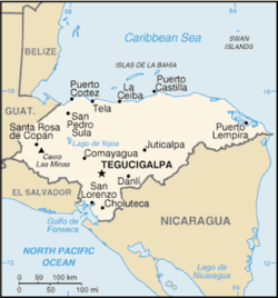
This is a list of airports in Honduras, sorted by location.

Honduras, officially the Republic of Honduras (Spanish: República de Honduras), is a republic in Central America. It was formerly known as Spanish Honduras to differentiate it from British Honduras (now Belize). The country is bordered to the west by Guatemala, to the southwest by El Salvador, to the southeast by Nicaragua, to the south by the Pacific Ocean at the Gulf of Fonseca, and to the north by the Gulf of Honduras, a large inlet of the Caribbean Sea. Its area is just over 112,000 square kilometres (43,000 sq mi) with an estimated population of almost 8 million inhabitants. The nation is currently divided into 18 departments (departamentos). The capital city of Honduras is Tegucigalpa.
Airports
editNames shown in bold indicate the airport has scheduled passenger service on commercial airlines.
The following airports have unverified coordinates:
| Location served | Department | ICAO | IATA | Airport name |
|---|---|---|---|---|
| Comayagua | Comayagua | MHCG | Comayagua Airport | |
| El Progreso | Yoro | MHPE | El Progreso Airport | |
| Iriona | Colón | MHIR | IRN | Iriona Airport |
| Juticalpa | Olancho | MHJU | JUT | Juticalpa Airport |
| Limón | Colón | MHLN | LMH | Limón Airport |
| Puerto Cortés | Cortés | MHPU | Puerto Cortes Airport | |
| San Esteban | Colón | SET | San Esteban Airport | |
| Sulaco | Yoro | MHUL | SCD | Sulaco Airport |
| Tocoa | Colón | MHTO | TCF | Tocoa Airport |
See also
editReferences
edit- "ICAO Location Indicators by State" (PDF). International Civil Aviation Organization. 2006-01-12.
- "UN Location Codes: Honduras". UN/LOCODE 2009-2. UNECE. 2010-02-08. - includes IATA codes
- World Aero Data: Honduras[usurped] - ICAO codes and airport data
- Great Circle Mapper: Honduras - IATA and ICAO codes