Lakeland is a city in Shelby County, Tennessee, United States, and a part of the Memphis metropolitan area. The population was 12,430 at the 2010 census.
Lakeland, Tennessee | |
|---|---|
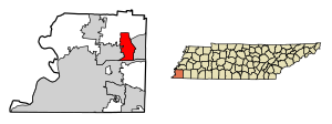
 Location of Lakeland in Shelby County, Tennessee. | |
| Coordinates: 35°13′50″N 89°44′25″W / 35.23056°N 89.74028°W | |
| Country | United States |
| State | Tennessee |
| County | Shelby |
| Government | |
| • Mayor | Josh Roman |
| Area | |
• Total | 23.87 sq mi (61.83 km2) |
| • Land | 23.46 sq mi (60.75 km2) |
| • Water | 0.42 sq mi (1.08 km2) |
| Elevation | 397 ft (121 m) |
| Population | |
• Total | 13,904 |
| • Density | 592.77/sq mi (228.87/km2) |
| Time zone | UTC-6 (Central (CST)) |
| • Summer (DST) | UTC-5 (CDT) |
| ZIP code | 38002 |
| Area code | 901 |
| FIPS code | 47-40350[3] |
| GNIS feature ID | 1313627 [4] |
| Website | www |
History
editThe city was the location of the now defunct Lakeland Amusement Park. The city was originally themed around the Lake now called Garner Lake. It had two railroads within the park property, including the 3 ft (914 mm) narrow gauge[5] Huff 'n' Puff Railroad and a separate 16 in (406 mm) miniature railway[6][7] railroad made by the Allan Herschell Company.
First Amendment Lawsuit
editIn June 2024, Lakeland resident and US Navy veteran Julie Pereira sued the city of Lakeland for violating her First Amendment rights when it fined Pereira hundreds of dollars for violating the city's regulation against obscene content on signs, after she displayed a political sign in her yard that read 'Fuck Em' Both 2024', referring to 2024 US presidential election candidates Joe Biden and Donald Trump.[8][9] In July 2024, US District Judge Mark Norris ruled that Pereira's sign was not obscene and that it was unconstitutional for the city to regulate political points of view, citing as precedent the 1971 decision by the US Supreme Court in the case of Cohen v. California, and ordered the city to reimburse Pereira nearly $700 in fines and to pay her $31,000 in legal fees and $1 in damages.[8][9]
Geography
editLakeland is located at 35°13′50″N 89°44′25″W / 35.23056°N 89.74028°W. According to the United States Census Bureau, the city has a total area of 18.0 square miles (47 km2), of which 17.6 square miles (46 km2) is land and 0.4 square miles (1.0 km2) (2.33%) is water.
Demographics
edit| Census | Pop. | Note | %± |
|---|---|---|---|
| 1980 | 612 | — | |
| 1990 | 1,204 | 96.7% | |
| 2000 | 6,862 | 469.9% | |
| 2010 | 12,430 | 81.1% | |
| 2020 | 13,904 | 11.9% | |
| Sources:[10][11][2] | |||
2020 census
edit| Race | Num. | Perc. |
|---|---|---|
| White (non-Hispanic) | 10,110 | 72.71% |
| Black or African American (non-Hispanic) | 1,372 | 9.87% |
| Native American | 29 | 0.21% |
| Asian | 771 | 5.55% |
| Pacific Islander | 4 | 0.03% |
| Other/Mixed | 642 | 4.62% |
| Hispanic or Latino | 976 | 7.02% |
As of the 2020 United States Census, there were 13,904 people, 4,148 households, and 3,322 families residing in the city.
2000 census
editCurrent population from the 2010 census is 12,430. At the 2000 census there were 6,862 people, 2,748 households, and 2,025 families living in the city. The population density was 389.5 inhabitants per square mile (150.4/km2). There were 2,904 housing units at an average density of 164.8 units per square mile (63.6 units/km2). The racial makeup of the city was 91.56% White, 5.22% African American, 0.13% Native American, 1.78% Asian, 0.50% from other races, and 0.82% from two or more races. Hispanic or Latino of any race were 1.47%.[3]
Of the 2,748 households 34.0% had children under the age of 18 living with them, 63.9% were married couples living together, 7.3% had a female householder with no husband present, and 26.3% were non-families. 22.0% of households were one person and 4.5% had someone living alone who was 65 years of age or older. The average household size was 2.50 and the average family size was 2.94.
The age distribution was 24.6% under the age of 18, 6.4% from 18 to 24, 37.2% from 25 to 44, 23.8% from 45 to 64, and 7.9% who were 65 years of age or older. The median age was 35 years. For every 100 females there were 95.1 males. For every 100 females age 18 and over, there were 94.5 males.
The median household income was $58,897 and the median family income was $64,444. Males had a median income of $46,750 versus $32,366 for females. The per capita income for the city was $28,956. About 2.2% of families and 3.0% of the population were below the poverty line, including 4.4% of those under age 18 and 2.8% of those age 65 or over.
Education
editLakeland is served by the Lakeland School System (LSS) and Arlington Community Schools.
Assigned schools are as follows:
Lakeland Elementary School (Grades K-4)
Lakeland Preparatory School (Grades 5–11)
Arlington High School (Grades 9–12)
NOTE: Students in grade 12 living in Lakeland are zoned attend Arlington High School through an inter-local agreement with Arlington Community Schools.[13]
References
edit- ^ "ArcGIS REST Services Directory". United States Census Bureau. Retrieved October 15, 2022.
- ^ a b "Census Population API". United States Census Bureau. Retrieved October 15, 2022.
- ^ a b "U.S. Census website". United States Census Bureau. Retrieved January 31, 2008.
- ^ "Lakeland". Geographic Names Information System. United States Geological Survey, United States Department of the Interior. Retrieved February 7, 2009.
- ^ "Surviving Steam Locomotive Search". Archived from the original on February 1, 2014. Retrieved January 28, 2014.
- ^ "Website with picture of Lakeland Amusement Park's smaller railroad". Archived from the original on February 1, 2014. Retrieved January 29, 2014.
- ^ "Allan Herschell catalog with model of Lakeland Amusement Park's smaller railroad listed". Archived from the original on February 3, 2014. Retrieved January 29, 2014.
- ^ a b Matisse, Jonathan (July 10, 2024). "A city's fine for a profane yard sign about Biden and Trump was unconstitutional, judge rules". AP News. Archived from the original on July 10, 2024. Retrieved July 11, 2024.
- ^ a b Jiménez, Jesus (July 10, 2024). "City Illegally Fined Woman Over Profane Political Yard Sign, U.S. Judge Rules". The New York Times. ISSN 0362-4331. Archived from the original on July 11, 2024. Retrieved July 11, 2024.
- ^ "Census of Population and Housing: Decennial Censuses". United States Census Bureau. Retrieved March 4, 2012.
- ^ "Incorporated Places and Minor Civil Divisions Datasets: Subcounty Resident Population Estimates: April 1, 2010 to July 1, 2012". Population Estimates. U.S. Census Bureau. Archived from the original on June 11, 2013. Retrieved December 11, 2013.
- ^ "Explore Census Data". data.census.gov. Retrieved December 8, 2021.
- ^ "Schools - Lakeland School System".
External links
edit- Lakeland, Tennessee is at coordinates 35°13′50″N 89°44′25″W / 35.23056°N 89.74028°W.

