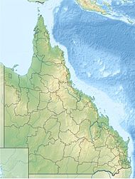
Kirrama National Park is a national park in Minnamoolka, Tablelands Region of Far North Queensland, Australia. The park protects rugged mountain landscapes, lush tropical rainforest and open eucalypt forests.
| Kirrama National Park Queensland | |
|---|---|
| Nearest town or city | Mount Garnet |
| Coordinates | 18°27′12″S 144°56′59″E / 18.45333°S 144.94972°E |
| Established | 2006 |
| Area | 75.80 km2 (29.3 sq mi) |
| Managing authorities | Queensland Parks and Wildlife Service |
| Website | Kirrama National Park |
| See also | Protected areas of Queensland |
It forms part of the Wet Tropics World Heritage Area. The park lies with the water catchment area of the Burdekin River. There are a diverse range of plants and animals found in the area.
Access
editAccess to the park is provided by the Kennedy Development Road south of Mount Garnet.[1] In 2011, access to the park was restricted when Kirrama Range Road was closed.[2] The historic gravel track and numerous bridges were damaged by floods after Cyclone Yasi passed through the area in early 2011.[citation needed]
Facilities
editThere are no facilities in the park except for the Society Flat rainforest walk which consists of a 720 m long circuit.[1] Camping is not permitted within the park.[1]
See also
editReferences
edit- ^ a b c "About Kirrama". Department of National Parks, Recreation, Sport and Racing. 9 July 2014. Retrieved 22 August 2014.
- ^ Sam Davis (26 August 2011). "Coastal link road closed". ABC Far North Queensland. Australian Broadcasting Corporation. Retrieved 22 August 2014.
