Juvignac (French pronunciation: [ʒyviɲak]; Occitan: Juvinhac) is a commune in the Hérault département in the Occitanie region in southern France.
Juvignac | |
|---|---|
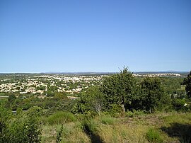
 A general view of Juvignac | |
| Coordinates: 43°36′50″N 3°48′38″E / 43.6139°N 3.8106°E | |
| Country | France |
| Region | Occitania |
| Department | Hérault |
| Arrondissement | Montpellier |
| Canton | Lattes |
| Intercommunality | Montpellier Méditerranée Métropole |
| Government | |
| • Mayor (2020–2026) | Jean-Luc Savy[1] |
Area 1 | 10.83 km2 (4.18 sq mi) |
| Population (2021)[2] | 12,783 |
| • Density | 1,200/km2 (3,100/sq mi) |
| Time zone | UTC+01:00 (CET) |
| • Summer (DST) | UTC+02:00 (CEST) |
| INSEE/Postal code | 34123 /34990 |
| Elevation | 22.5–145 m (74–476 ft) |
| 1 French Land Register data, which excludes lakes, ponds, glaciers > 1 km2 (0.386 sq mi or 247 acres) and river estuaries. | |
Geography
editThe commune borders Montpellier to the east (separated by the Mosson River), Lavérune and Saint-Jean-de-Védas to the south (meeting at a quadripoint), Saint-Georges-d'Orques to the west, and Grabels to the north. Juvignac is the most populous commune in the western arc of Montpellier. It enjoys a Mediterranean climate, with over three hundred days of sunshine annually.
Climate
editIn 2010, the climate of the commune is classified as a frank Mediterranean climate, according to a study based on a dataset covering the 1971-2000 period.[3] In 2020, Météo-France published a typology of climates in mainland France in which the commune is exposed to a Mediterranean climate and is part of the Provence, Languedoc-Roussillon climatic region, characterized by low rainfall in summer, very good sunshine (2,600 h/year), a hot summer 21.5 °C (71 °F), very dry air in summer, dry conditions in all seasons, strong winds (with a frequency of 40 to 50% for winds > 5 m/s), and little fog.[4]
For the 1971-2000 period, the average annual temperature was 14.4 °C (58 °F) with an annual atmospheric temperature of 16.5 °C (62 °F). The average annual total rainfall during this period was 695 mm, with 6 days of precipitation in January and 2.8 days in July.[3] For the subsequent period of 1991 to 2020, the average annual temperature observed at the nearest weather station, located in the commune of Prades-le-Lez, 10 kilometres (6 mi) away as the crow flies,[5] is 14.6 °C (58 °F), and the average annual total rainfall is 869.7 mm.[6][7]
For the future, climate parameters for the commune projected for 2050, based on different greenhouse gas emission scenarios, can be consulted on a dedicated website published by Météo-France in November 2022.[8]
Natural environments and biodiversity
editThe inventory of natural areas of ecological, faunistic, and floristic interest (Zone naturelle d'intérêt écologique, faunistique et floristique, ZNIEFF) is a French national program aimed at identifying ecologically significant areas to enhance knowledge of natural heritage and aid decision-makers in integrating environmental concerns into land-use planning. One type 1 ZNIEFF[Note 1] is recorded in the commune:[9] the 'Mosson Valley from Grabels to St-Jean-de-Védas', covering approximately 114 hectares (282 acres) across five communes in the department.[10]
Urbanism
editTypology
editAs of January 1, 2024, Juvignac is classified as an ‘ceinture urbaine’ (urban belt) according to the new seven-level commune density grid established by Insee in 2022.[l 1] It is part of the urban unit of Montpellier,[Note 2] an intra-departmental agglomeration comprising 22 communes, of which Juvignac is a suburban commune.[Note 3][l 2][l 3] Additionally, Juvignac belongs to the Montpellier attraction area, where it is designated as a commuter town.[Note 4][l 3] This area, encompassing 161 communes, falls under the category of areas with 700,000 inhabitants or more (excluding Paris).[l 4]
Population
editChanges in the number of inhabitants have been documented through population censuses conducted in the commune since 1793. For communes with over 10,000 inhabitants, censuses are conducted annually via a survey based on a sampling of addresses representing 8% of the dwellings. This differs from other communes, where a full census is conducted every five years.[11][Note 5]
In 2021, the commune had a population of 12,783;[Note 6] reflecting an increase of +20,27% since 2015 (Hérault: +7.29%, France excluding Mayotte: +1.84%).
|
| |||||||||||||||||||||||||||||||||||||||||||||||||||||||||||||||||||||||||||||||||||||||||||||||||||||||||||||||||||||
| Source: Ldh/EHESS/Cassini until 1999,[12] and INSEE since 2006.[13] | ||||||||||||||||||||||||||||||||||||||||||||||||||||||||||||||||||||||||||||||||||||||||||||||||||||||||||||||||||||||
See also
editNotes and references
editNotes
edit- ^ Type 1 ZNIEFF are areas generally of limited size, characterized by the presence of rare or remarkable species, species associations, or habitats that are typical of the regional or national natural heritage.
- ^ An urban unit in France is defined as a commune or a group of communes with a continuous built-up area (no gap greater than 200 meters between two buildings) and a population of at least 2,000 inhabitants. A commune must have more than half of its population within this built-up area to qualify as part of an urban unit.
- ^ In a multi-communal agglomeration, a commune is classified as suburban when it is not the central city; this means its population is less than 50% of the agglomeration’s total population or that of the most populated commune. In the case of the Montpellier urban unit, there is one central city and 21 suburban communes.
- ^ The concept of an functional area replaced the former concept of an urban area in October 2020, enabling consistent comparisons with other European Union countries.
- ^ By convention on Wikipedia, only populations from exhaustive census surveys are displayed in the census table and graph for populations after 1999 in communes with fewer than 10,000 inhabitants. For communes with over 10,000 inhabitants, populations from the years 2006, 2011, 2016, etc., are shown, along with the most recent legal population published by INSEE for all communes.
- ^ Legal municipal population effective as of January 1, 2024, based on 2021 data, defined within the territorial boundaries effective as of January 1, 2023, with a statistical reference date of January 1, 2021.
References
editInsee website
edit- ^ "La grille communale de densité". insee.fr (in French). 28 May 2024. Retrieved 26 October 2024.
- ^ "Unité urbaine 2020 de Montpellier". insee.fr (in French). Retrieved 26 October 2024.
- ^ a b "Métadonnées de la commune de Juvignac". Insee (in French).
- ^ "Liste des communes composant l'aire d'attraction de Montpellier". insee.fr (in French). Retrieved 26 October 2024.
Other sources
edit- ^ "Répertoire national des élus: les maires" (in French). data.gouv.fr, Plateforme ouverte des données publiques françaises. 13 September 2022.
- ^ "Populations légales 2021" (in French). The National Institute of Statistics and Economic Studies. 28 December 2023.
- ^ a b Joly, Daniel; Brossard, Thierry; Cardot, Hervé; Cavailhes, Jean; Hilal, Mohamed; Wavresky, Pierre (18 June 2010). "Climate Types in France: A Spatial Construction". Cybergéo, European Journal of Geography (501). doi:10.4000/cybergeo.23155. Retrieved 26 October 2024.
- ^ "Zonages climatiques en France métropolitaine". pluiesextremes.meteo.fr. Retrieved 25 October 2024.
- ^ "Orthodromie entre Juvignac et Prades-le-Lez". fr.distance.to. Retrieved 25 October 2024.
- ^ "Station Météo-France « Prades-le-Lez » (commune de Prades-le-Lez) - fiche climatologique - période 1991-2020" (PDF). donneespubliques.meteofrance.fr. Retrieved 25 October 2024.
- ^ "Station Météo-France « Prades-le-Lez » (commune de Prades-le-Lez) - fiche de métadonnées" (PDF). donneespubliques.meteofrance.fr. Retrieved 25 October 2024.
- ^ "Climadiag Commune:diagnostiquez les enjeux climatiques de votre collectivité". meteofrance.fr (in French). November 2022. Retrieved 25 October 2024.
- ^ "Liste des ZNIEFF de la commune de Juvignac". Inventaire national du patrimoine naturel (in French). Retrieved 26 October 2024.
- ^ "ZNIEFF la « vallée de la Mosson de Grabels à St-Jean-de-Védas » - fiche descriptive". Inventaire national du patrimoine naturel (in French). Retrieved 26 October 2024.
- ^ "L'organisation du recensement". insee.fr.
- ^ "Des villages de Cassini aux communes d'aujourd'hui". École des hautes études en sciences sociales (in French). Retrieved 25 October 2024.
- ^
Statistical data from INSEE for various years:
- 2006: INSEE 2006
- 2007: INSEE 2007
- 2008: INSEE 2008
- 2009: INSEE 2009
- 2010: INSEE 2010
- 2011: INSEE 2011
- 2012: INSEE 2012
- 2013: INSEE 2013
- 2014: INSEE 2014
- 2015: INSEE 2015
- 2016: INSEE 2016
- 2017: INSEE 2017
- 2018: INSEE 2018
- 2019: INSEE 2019
- 2020: INSEE 2020
- 2021: INSEE 2021


