Jefferson Davis County is a county located in the U.S. state of Mississippi. As of the 2020 census, the population was 11,321.[1] Its county seat is Prentiss.[2] The county is named after Mississippi Senator and Confederate President Jefferson Davis. The county was carved out of Covington and Lawrence counties in March 1906. Governor James K. Vardaman signed the bill creating the county on May 9, 1906.
Jefferson Davis County | |
|---|---|
County | |
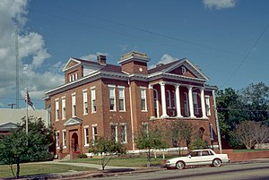
 Jefferson Davis County Courthouse in Prentiss | |
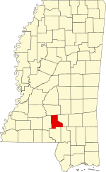
 Location within the U.S. state of Mississippi | |
 Mississippi's location within the U.S. | |
| Coordinates: 31°34′N 89°49′W / 31.56°N 89.82°W | |
| Country | |
| State | |
| Founded | 1906 |
| Named for | Jefferson Davis |
| Seat | Prentiss |
| Largest town | Prentiss |
| Area | |
• Total | 409 sq mi (1,060 km2) |
| • Land | 408 sq mi (1,060 km2) |
| • Water | 0.7 sq mi (2 km2) 0.2% |
| Population (2020) | |
• Total | 11,321 |
| • Density | 28/sq mi (11/km2) |
| Time zone | UTC−6 (Central) |
| • Summer (DST) | UTC−5 (CDT) |
| Congressional district | 3rd |
| Website | www.jeffersondaviscountyms.com |
History
editThe genesis of the county occurred on March 31, 1906, when a Mississippi state legislative act authorized the new country's boundaries. The residents of western Covington County and eastern Lawrence County had frequently complained of the rivers and streams impeding the route to their respective county seats. Jefferson Davis County was the state's 77th county.
A 1906 special referendum determined that the county seat would be Prentiss, named for either famed Mississippi lawmaker and orator Seargent Smith Prentiss, or wealthy landowner Prentiss Webb Berry. The settlement was originally named Blountville after early settler William Blount.
In 1933, the county was the first in Mississippi to issue a prohibition on alcohol after the repeal of the Eighteenth Amendment to the United States Constitution. Round dancing in the community hall was banned in 1938.
In 1935, notorious bank robber Raymond Hamilton, known to hide out in the county's wilderness, was involved in a hostage situation after robbing Prentiss' Bank of Blountville, but escaped in Memphis.[3]
Geography
editAccording to the U.S. Census Bureau, the county has a total area of 409 square miles (1,060 km2), of which 408 square miles (1,060 km2) is land and 0.7 square miles (1.8 km2) (0.2%) is water.[4]
Major highways
edit- U.S. Route 84
- Mississippi Highway 13
- Mississippi Highway 35
- Mississippi Highway 42
- Mississippi Highway 43
Adjacent counties
edit- Simpson County (north)
- Covington County (east)
- Lamar County (southeast)
- Marion County (south)
- Lawrence County (west)
Demographics
edit| Census | Pop. | Note | %± |
|---|---|---|---|
| 1910 | 12,860 | — | |
| 1920 | 12,755 | −0.8% | |
| 1930 | 14,281 | 12.0% | |
| 1940 | 15,869 | 11.1% | |
| 1950 | 15,500 | −2.3% | |
| 1960 | 13,540 | −12.6% | |
| 1970 | 12,936 | −4.5% | |
| 1980 | 13,846 | 7.0% | |
| 1990 | 14,051 | 1.5% | |
| 2000 | 13,962 | −0.6% | |
| 2010 | 12,487 | −10.6% | |
| 2020 | 11,321 | −9.3% | |
| 2023 (est.) | 10,969 | [5] | −3.1% |
| U.S. Decennial Census[6] 1790-1960[7] 1900-1990[8] 1990-2000[9] 2010-2013[10] | |||
| Race | Num. | Perc. |
|---|---|---|
| White (non-Hispanic) | 4,330 | 38.25% |
| Black or African American (non-Hispanic) | 6,622 | 58.49% |
| Native American | 8 | 0.07% |
| Asian | 21 | 0.19% |
| Other/Mixed | 239 | 2.11% |
| Hispanic or Latino | 101 | 0.89% |
As of the 2020 United States census, there were 11,321 people, 4,713 households, and 3,003 families residing in the county.
Communities
editTowns
editUnincorporated communities
edit- Carson
- Oak Vale (partly in Lawrence County)
Ghost town
editPolitics
editTypical of a majority-black county in Mississippi, Jefferson Davis leans Democratic and last voted Republican in 1984.
| Year | Republican | Democratic | Third party(ies) | |||
|---|---|---|---|---|---|---|
| No. | % | No. | % | No. | % | |
| 2024 | 2,302 | 42.80% | 3,041 | 56.55% | 35 | 0.65% |
| 2020 | 2,534 | 40.79% | 3,599 | 57.93% | 80 | 1.29% |
| 2016 | 2,466 | 39.54% | 3,720 | 59.64% | 51 | 0.82% |
| 2012 | 2,507 | 36.52% | 4,267 | 62.16% | 90 | 1.31% |
| 2008 | 2,871 | 38.96% | 4,454 | 60.43% | 45 | 0.61% |
| 2004 | 2,668 | 46.28% | 2,959 | 51.33% | 138 | 2.39% |
| 2000 | 2,437 | 45.83% | 2,835 | 53.32% | 45 | 0.85% |
| 1996 | 1,890 | 38.84% | 2,663 | 54.73% | 313 | 6.43% |
| 1992 | 2,228 | 39.55% | 2,991 | 53.10% | 414 | 7.35% |
| 1988 | 2,745 | 47.92% | 2,948 | 51.47% | 35 | 0.61% |
| 1984 | 2,884 | 51.81% | 2,644 | 47.50% | 38 | 0.68% |
| 1980 | 2,280 | 36.85% | 3,831 | 61.92% | 76 | 1.23% |
| 1976 | 1,868 | 39.76% | 2,747 | 58.47% | 83 | 1.77% |
| 1972 | 2,830 | 72.83% | 1,005 | 25.86% | 51 | 1.31% |
| 1968 | 297 | 6.79% | 1,465 | 33.48% | 2,614 | 59.73% |
| 1964 | 2,351 | 90.91% | 235 | 9.09% | 0 | 0.00% |
| 1960 | 225 | 13.06% | 510 | 29.60% | 988 | 57.34% |
| 1956 | 156 | 10.92% | 1,049 | 73.41% | 224 | 15.68% |
| 1952 | 473 | 22.53% | 1,626 | 77.47% | 0 | 0.00% |
| 1948 | 51 | 3.30% | 41 | 2.66% | 1,452 | 94.04% |
| 1944 | 88 | 6.03% | 1,372 | 93.97% | 0 | 0.00% |
| 1940 | 38 | 2.86% | 1,289 | 96.92% | 3 | 0.23% |
| 1936 | 67 | 4.81% | 1,325 | 95.05% | 2 | 0.14% |
| 1932 | 30 | 3.09% | 940 | 96.71% | 2 | 0.21% |
| 1928 | 163 | 16.00% | 856 | 84.00% | 0 | 0.00% |
| 1924 | 88 | 10.73% | 732 | 89.27% | 0 | 0.00% |
| 1920 | 179 | 26.76% | 485 | 72.50% | 5 | 0.75% |
| 1916 | 45 | 6.59% | 634 | 92.83% | 4 | 0.59% |
| 1912 | 43 | 6.63% | 542 | 83.51% | 64 | 9.86% |
Historic sites
editJefferson Davis County Courthouse in Prentiss is listed on the National Register of Historic Places.
Education
editAll residents are zoned to the Jefferson Davis County School District.[13]
The county is in the zone of Pearl River Community College.[14]
See also
editReferences
edit- ^ "Census - Geography Profile: Jefferson Davis County, Mississippi". United States Census Bureau. Retrieved January 9, 2023.
- ^ "Find a County". National Association of Counties. Archived from the original on May 31, 2011. Retrieved June 7, 2011.
- ^ "Jefferson Davis County Mississippi Genealogy & History Network". jeffdavis.msghn.org. Retrieved March 3, 2018.
- ^ "2010 Census Gazetteer Files". United States Census Bureau. August 22, 2012. Archived from the original on September 28, 2013. Retrieved November 4, 2014.
- ^ "Annual Estimates of the Resident Population for Counties: April 1, 2020 to July 1, 2023". United States Census Bureau. Retrieved April 5, 2024.
- ^ "U.S. Decennial Census". United States Census Bureau. Retrieved November 4, 2014.
- ^ "Historical Census Browser". University of Virginia Library. Retrieved November 4, 2014.
- ^ "Population of Counties by Decennial Census: 1900 to 1990". United States Census Bureau. Retrieved November 4, 2014.
- ^ "Census 2000 PHC-T-4. Ranking Tables for Counties: 1990 and 2000" (PDF). United States Census Bureau. Archived (PDF) from the original on March 27, 2010. Retrieved November 4, 2014.
- ^ "State & County QuickFacts". United States Census Bureau. Archived from the original on June 7, 2011. Retrieved September 3, 2013.
- ^ "Explore Census Data". data.census.gov. Retrieved December 16, 2021.
- ^ Leip, David. "Dave Leip's Atlas of U.S. Presidential Elections". uselectionatlas.org. Retrieved March 3, 2018.
- ^ "2020 CENSUS - SCHOOL DISTRICT REFERENCE MAP: Jefferson Davis County, MS" (PDF). U.S. Census Bureau. Retrieved September 27, 2024. - Text list
- ^ "2014-2016 Catalog" (PDF). Pearl River Community College. Archived from the original (PDF) on August 7, 2015. Retrieved April 13, 2022.