This article's use of external links may not follow Wikipedia's policies or guidelines. (December 2024) |
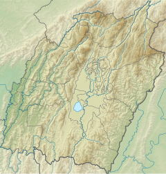
The Imphal River (Meitei: Imphal Turel[2][3][4][5][6]), also known as the Turel Achouba,[7] is a major river in Manipur state, northeastern India which originates from the northern side of Kangpokpi district.[8] It is a tributary of the Manipur River, joining it in Thoubal district.[9] It flows past Loktak Lake and the city of Imphal and joins the Lilong River, some 10 kilometres (6.2 mi) to the south.[10][11] It flows towards Myanmar (Burma), marking the end point at 23°59'49.2"N 93°44'29.7"E. It then goes south meeting Myittha River at 22°53'24.19"N, 94° 5'1.79"E. Myittha river flows towards north[12] and meets Chindwin River (also called as Ningthi River[13]) at 23°11'36.82"N, 94°18'38.28"E. Chindwin river then meets Irrawaddy River at 21°25'23.85"N, 95°16'47.56"E. Irrawaddy river then flows south till it ends at Andaman Sea, adjoining the Bay of Bengal and thereby connecting Imphal city to the sea. Imphal River was used by Japanese soldiers in boats to reach Imphal in World War II.
| Imphal River Turel Achouba[1] | |
|---|---|
| Etymology | Great River |
| Native name | Imphal Turel (Meitei) |
| Physical characteristics | |
| Source | Nilakuthi, at the confluence of two rivers Leimakhong and Sekmai River |
| Mouth | |
• coordinates | 24°25′47″N 93°50′19″E / 24.4297589°N 93.838581°E |
| Discharge | |
| • location | Ithai, Waipokpi |
| Basin features | |
| Tributaries | |
| • left | Tuitha River |
| • right | Kongba River, Iril River, Thoubal River |
References
edit- ^ Singh, Arambam Sanatomba (4 January 2021). Challenges of Climate Change in Manipur: Strategies and Action Plans. Walnut Publication. p. 7. ISBN 978-1-954399-41-9.
- ^ Mineral Development in Assam: Symposium Volume. Directorate of Geology and Mining, Government of Assam. 1964. p. 235.
- ^ Warwick, Nigel W. M. (19 September 2014). Constant Vigilance: The RAF Regiment in the Burma Campaign. Pen and Sword. p. 97. ISBN 978-1-78346-008-3.
- ^ Katoch, Hemant Singh (9 March 2018). Imphal 1944: The Japanese invasion of India. Bloomsbury Publishing. p. 170. ISBN 978-1-4728-2017-4.
- ^ Devi, Nunglekpam Premi (25 May 2018). Short Essays on Women and Society: Manipuri Women through the Century. FSP Media Publications. p. 17.
- ^ Singh, Arambam Sanatomba (4 January 2021). Challenges of Climate Change in Manipur: Strategies and Action Plans. Walnut Publication. p. 7. ISBN 978-1-954399-41-9.
- ^ Singh, Arambam Sanatomba (4 January 2021). Challenges of Climate Change in Manipur: Strategies and Action Plans. Walnut Publication. p. 7. ISBN 978-1-954399-41-9.
- ^ "River and Drainage System of Manipur".
- ^ Sen, Sipra (August 1992). Tribes and castes of Manipur: description and select bibliography. Mittal Publications. p. 37. ISBN 978-81-7099-310-0. Retrieved 27 March 2011.
- ^ Sengupta, Sutapa (1 January 2006). Rivers and riverine landscape in North East India. Concept Publishing Company. p. 19. ISBN 978-81-8069-276-5. Retrieved 27 March 2011.
- ^ Sharma, S. C.; Chaturvedi, Rachna B. (1990). Utilisation of wastelands for sustainable development in India: proceedings of the National Seminar on Utilisation of Wastelands for Sustainable Development in India, Balrampur, 1987. M.L.K. (P.G.) College, Balrampur Pub. Co. p. 362. ISBN 978-81-7022-279-8. Retrieved 27 March 2011.
- ^ "1:250,000 topographic map, Series U542, Mawlaik, Burma; India, NF 46-3" U.S. Army Map Service, March 1960
- ^ Pemberton, R. Boileau (1835). Report On The Eastern Frontier Of British India. Baptist Mission Press, Kolkata. pp. 19–20.; McCulloch, W.Maj (1859). Account of the Valley of Munnipore and of the Hill Tribes; with a Comparative Vocabulary of the Munnipore and other Languages
24°50′35″N 93°57′29″E / 24.84306°N 93.95806°E

