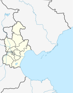
Hexiwu Town (simplified Chinese: 河西务镇; traditional Chinese: 河西務鎮; pinyin: Héxīwù Zhèn), formerly known as Ho-Hsi-Wu, is a town situated on the northern part of Wuqing District, Tianjin, China. It borders Yongledian and Anping Towns to the north, Qiantun Township and Xiawuqi Town to the east, Damengzhuang and Daliang Towns to the south, as well as Baigutun and Gaocun Towns to the west. In the year 2010, the town was home to 45,814 residents.[1]
Hexiwu Town
河西务镇 | |
|---|---|
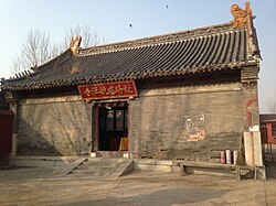
 Cihang Chanlin Temple within Xiaoli Village, Hexiwu Town | |
| Coordinates: 39°37′21″N 116°57′14″E / 39.62250°N 116.95389°E | |
| Country | |
| Municipality | Tianjin |
| District | Wuqing |
| Village-level Divisions | 2 communities 51 villages |
| Area | |
• Total | 70.11 km2 (27.07 sq mi) |
| Elevation | 12 m (39 ft) |
| Population (2010) | |
• Total | 45,814 |
| • Density | 650/km2 (1,700/sq mi) |
| Time zone | UTC+8 (CST) |
| Postal code | 301711 |
| Area code | 022 |
This town got the name Hexiwu (Chinese: 河西务; lit. 'River West Affair') for its location on the west of the Grand Canal and hosting local taxation agency during the Yuan Dynasty.[2]
Geography
editHexiwu Town is located along the Grand Canal. It has an average elevation of 12 meters above the sea level.[3]
History
editDuring the Ming dynasty, the bursting of several dikes at Hexiwu touched off a crisis in 1424. Mu Jin and Zhang Xin directed efforts by more than 5,000 workers from the Ministry of Public Works to repair the damage and restore the irrigation system.[4]
The site played a minor role during the Boxer Rebellion, seeing battle on 25 July between the international relief force and the Kansu Braves under Dong Fuxiang.[5]
Administrative divisions
editAt the end of 2022, Hexiwu Town covered 53 subdivisions, where 2 were residential communities and 51 were villages. They are listed below:[6]
Residential Communities
edit- Taiyangcheng (太阳城)
- Dongxingli (东兴里)
Villages
edit- Wuqi (五七)
- Sanjie (三街)
- Sijie (四街)
- Zhouyangzhuang (周羊庄)
- Tucheng (土城)
- Dalongzhuang (大龙庄)
- Zhengzhuang (郑庄)
- Xiaolongzhuang (小龙庄)
- Bei Sanlitun (北三里屯)
- Shangliuzhuang (上刘庄)
- Naimuzhuang (奶母庄)
- Qianbaimiao (前白庙)
- Zhongbaimiao (中白庙)
- Dongbaimiao (东白庙)
- Suozhuang (索庄)
- Gaozhuang (高庄)
- Baizhuang (白庄)
- Tangzhuang (唐庄)
- Yuezhuang (岳庄)
- Futou Houjie (扶头后街)
- Futou Qianjie (扶头前街)
- Sijianfang (四间房)
- Shiqiao Xinzhuang (石桥辛庄)
- Dongxi Chenzhuang (东西陈庄)
- Xiaozhuang (肖庄)
- Baoshizhuang (宝石庄)
- Liufeng (刘坟)
- Baolou (包楼)
- Xiaoli (孝力)
- Hangzhuang (韩庄)
- Longzhuang (龚庄)
- Nancang (南仓)
- Cuilou (崔楼)
- Heyizhuang (合义庄)
- Bei Daxinzhuang (北大辛庄)
- Shangxinzhuang (上辛庄)
- Yangfang (羊坊)
- Dongxicang (东西仓)
- Matou (马头)
- Muchang (木厂)
- Xiaoshahe (小沙河)
- Zhuangwo (庄窝)
- Huangtun (黄屯)
- Beilizhuang (北里庄)
- Qinying (秦营)
- Shuiniu (水牛)
- Luzhuang (路庄)
- Dayoufa (大友垡)
- Maoyao (毛窑)
- Wawu (瓦屋)
- Dashahe (大沙河)
See also
editReferences
edit- ^ "China: Tiānjīn Municipal Province (Districts and Townships) - Population Statistics, Charts and Map". www.citypopulation.de. Retrieved 2023-07-02.
- ^ 中华人民共和国政区大典 天津卷 [Collection of Administrative Divisions of the People's Republic of China, Tianjin Volumn] (in Chinese) (Di 1 ban ed.). 2020. ISBN 978-7-5087-6215-9. OCLC 1351675957.
- ^ "Hexiwu topographic map, elevation, terrain". Topographic maps. Retrieved 2023-07-02.
- ^ Tsai, Shih-Shan Henry. SUNY Series in Chinese Local Studies: The Eunuchs in the Ming Dynasty. SUNY Press, 1996. ISBN 0791426874, 9780791426876. Accessed 16 Oct 2012.
- ^ Smith, Arthur Henderson (1901). China in convulsion. Vol. 2. F. H. Revell. pp. 393, 441–448. Retrieved 2010-06-28.
- ^ "2022年统计用区划代码和城乡划分代码" [2022 Statistical Division Codes and Urban-rural Differentiation Codes]. www.stats.gov.cn (in Chinese). Archived from the original on 2023-03-21. Retrieved 2023-07-02.

