Hemlock is an unincorporated community in Richland Township, Saginaw County in the U.S. state of Michigan. It is also a census-designated place (CDP) for statistical purposes, but without any legal status as an incorporated municipality. The population of the CDP was 1,585 at the 2000 census. The area included in the CDP is in the south central portion of Richland Township.[4] The Hemlock post office, with ZIP code 48626, serves nearly all of Richland Township, as well as portions of Fremont Township to the south, small areas of Thomas and Swan Creek townships to the southeast, and part of Ingersoll Township to the north in Midland County.[5]
Hemlock, Michigan | |
|---|---|
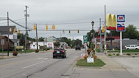
 Looking west along M-46 at N. Hemlock Road | |
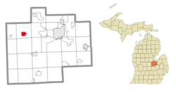
 Location within Saginaw County | |
| Coordinates: 43°25′07″N 84°13′52″W / 43.41861°N 84.23111°W[1] | |
| Country | United States |
| State | Michigan |
| County | Saginaw |
| Township | Richland |
| Area | |
• Total | 2.78 sq mi (7.19 km2) |
| • Land | 2.75 sq mi (7.13 km2) |
| • Water | 0.02 sq mi (0.06 km2) |
| Elevation | 650 ft (200 m) |
| Population (2020) | |
• Total | 1,408 |
| • Density | 511.63/sq mi (197.55/km2) |
| Time zone | UTC-5 (Eastern (EST)) |
| • Summer (DST) | UTC-4 (EDT) |
| ZIP code(s) | 48626 |
| Area code | 989 |
| FIPS code | 26-37600[3] |
| GNIS feature ID | 2393046[1] |
History
editThe community was first settled in 1865. A Post Office was established in 1869 with the name "Hemlock City". This was shortened to Hemlock in 1895.[6][7][8] Its annual festival, known as Sawdust Days, is held in September.[9] The festival started in the late 1970s after the local hardware store held a chainsaw promotion and demonstration on the third Saturday of September.[10]
Geography
editAccording to the United States Census Bureau, the CDP has a total area of 2.5 square miles (6.5 km2), all land.
Demographics
edit| Census | Pop. | Note | %± |
|---|---|---|---|
| 2020 | 1,408 | — | |
| U.S. Decennial Census[11] | |||
As of the census[3] of 2000, there were 1,585 people, 618 households, and 443 families residing in the CDP. The population density was 624.1 inhabitants per square mile (241.0/km2). There were 650 housing units at an average density of 255.9 per square mile (98.8/km2). The racial makeup of the CDP was 97.98% White, 0.13% African American, 0.32% Native American, 0.06% Asian, 1.32% from other races, and 0.19% from two or more races. Hispanic or Latino of any race were 2.78% of the population.
Out of the 618 households, 38.0% had children under the age of 18 living with them, 52.1% were married couples living together, 15.2% had a female householder with no husband present, and 28.3% were non-families. 24.8% of all households were made up of individuals, and 9.9% had someone living alone who was 65 years of age or older. The average household size was 2.55 and the average family size was 3.03.
In the CDP, the population was spread out, with 29.5% under the age of 18, 6.9% from 18 to 24, 30.6% from 25 to 44, 20.3% from 45 to 64, and 12.7% who were 65 years of age or older. The median age was 34 years. For every 100 females, there were 90.0 males. For every 100 females age 18 and over, there were 82.7 males.
The median income for a household in the CDP was $40,846, and the median income for a family was $45,074. Males had a median income of $42,448 versus $23,512 for females. The per capita income for the CDP was $18,085. About 9.5% of families and 9.9% of the population were below the poverty line, including 8.1% of those under age 18 and 7.0% of those age 65 or over.
References
edit- ^ a b c U.S. Geological Survey Geographic Names Information System: Hemlock, Michigan
- ^ "2020 U.S. Gazetteer Files". United States Census Bureau. Retrieved May 21, 2022.
- ^ a b "U.S. Census website". United States Census Bureau. Retrieved January 31, 2008.
- ^ There are two elementary schools, one middle school, and one high school. There are also smaller religious schools that may lead up to the high school level. Hemlock CDP, Michigan - Reference Map - American FactFinder[permanent dead link], U.S. Census Bureau, 2000 census
- ^ 48626 5-Digit ZCTA, 486 3-Digit ZCTA - Reference Map - American FactFinder[permanent dead link], U.S. Census Bureau, 2000 census
- ^ History of Saginaw County, Michigan. Mills, James Cooke. Saginaw: Seeman & Peters, 1918 pp. 414-417
- ^ Romig, Walter (1986) [1973]. Michigan Place Names. Detroit, Michigan: Wayne State University Press. ISBN 0-8143-1838-X.
- ^ Hemlock In The Headlines. Bohn, Matt. Bloomington: 1st Books, 2003 ISBN 1-4107-4406-X
- ^ "Hemlock Sawdust Days – September 16-18, 2016". www.hemlocksawdustdays.com. Retrieved August 24, 2017.
- ^ "Hemlock Sawdust Days". www.facebook.com. Retrieved August 24, 2017.
- ^ "Census of Population and Housing". Census.gov. Retrieved June 4, 2016.

