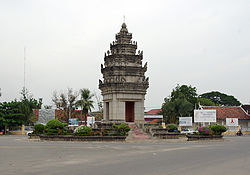
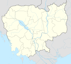
Doun Kaev municipality (Khmer: ក្រុងដូនកែវ, lit. 'Grandma Kaev') is a municipality (krong) in Takeo province, in southern Cambodia.
Doun Kaev municipality
ក្រុងដូនកែវ Krong Doun Kaev | |
|---|---|
 | |
| Coordinates: 10°59′15″N 104°46′58″E / 10.98750°N 104.78278°E | |
| Country | Cambodia |
| Province | Takéo |
| Quarters | 3 |
| Villages | 40 |
| Capital | Doun Kaev |
| Government | |
| • Type | City municipality |
| Population (2019)[1] | |
• Total | 43,402 |
| Time zone | UTC+7 (ICT) |
| District Code | 2108 |
Krong Doun Kaev was renamed from Doun Kaev district in accordance with Sub-Decree No. 226 អនក្រ.បក dated 30 December 2008.[2]
Administrative divisions
editAs of 2019, Krong Doun Kaev has three sangkats (quarters) and 40 villages.[2]
| No. | Code | Sangkat | Khmer | Number of villages |
|---|---|---|---|---|
| 1 | 2108-01 | Baray | បារាយណ៍ | 14 |
| 2 | 2108-02 | Roka Knong | រកាក្នុង | 12 |
| 3 | 2108-03 | Roka Krau | រកាក្រៅ | 14 |
References
edit- ^ "General Population Census of the Kingdom of Cambodia 2019: Final Census Results" (PDF) (1st ed.). National Institute of Statistics, Ministry of Planning, Cambodia. October 2020. p. 197. Retrieved 2022-09-21.
- ^ a b "Cambodia Gazetteer Database Online". Cambodia NCDD Databases. National Committee for Sub-National Democratic Development (NCDD). 2019. Retrieved 2019-08-24.
