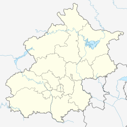
Dongsi (simplified Chinese: 东四; traditional Chinese: 東四; pinyin: Dōngsì,lit. "Eastern Four" or "Eastern Quadrangle") is the name of an intersection and surrounding neighborhood in Dongcheng District, Beijing. Dongsi, at the intersection of what is now Dongsi Avenues North, South and West and Chaoyangmen Inner Street, dates to the Yuan dynasty. The intersection is named after four paifangs or Chinese sign gates that marked the location and is known in Chinese as the Eastern Four Sign Gates or "Eastern Four" for short. Directly due west in Xicheng District, another intersection with four sign gates is called Xisi or the "Western Four".[1]
Dongsi Subdistrict
东四街道 | |
|---|---|
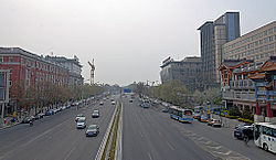 Looking west from Dongsi along Dongsi West Avenue with Jingshan visible in the distance | |
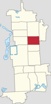 Location of Dongsi Subdistrict within Dongcheng District | |
| Coordinates: 39°55′44″N 116°25′3″E / 39.92889°N 116.41750°E | |
| Country | China |
| Municipality | Beijing |
| District | Dongcheng |
| Village-level Division | 6 communities |
| Area | |
| • Total | 1.42 km2 (0.55 sq mi) |
| Elevation | 50 m (164 ft) |
| Population (2020) | |
| • Total | 33,670 |
| Time zone | UTC+8 (China Standard) |
| Postal code | 100010 |
| Area code | 010 |
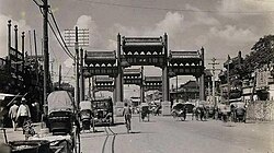
The sign gates at Dongsi and Xisi were removed in 1958 but the location names remain. Today, the Dongsi Station on Lines 5 and 6 of the Beijing Subway is located underneath the intersection. Beijing Bus 106, 110, 116, 684, and 夜10 stop south of the intersection. Bus 58, 101, 109, 112, 420, and 夜13 stop east of the intersection. Dongsi is known for the Longfusi Snack Street where traditional restaurants such as Baikuilaohao serve Beijing snack cuisine. The Dongsi Mosque, founded in 1356 and rebuilt in 1447, is located just south of the intersection.
History
edit| Year | Status |
|---|---|
| 1912 | Part of 3rd Inner District |
| 1949 | Part of Dongcheng District. Following subidistricts were created:
|
| 1955 | Jibei and Batiao merged to form Xinsi Subdistrict |
| 1958 | The 3 subdistricted merged to create Dongsi Subdistrict |
| 1960 | Changed to a commune |
| 1990 | Reinstated as a subdistrict |
Dongsi Subdistrict
editThe neighborhood northeast of Dongsi, extending north to Dongsi Shitiao and east to the Second Ring Road, is administered as the Dongsi Subdistrict of Dongcheng District. The subdistrict was established in 1958 and As of 2011[update], consists of eight residential communities.[3] As of 2020, the Dongsi Subdistrict has a population of 33,670 and an area of 1.42 square kilometres (0.55 sq mi).[4]
In 2021, the subdistrict was divided into the 6 following communities:[5]
| Administrative Division Code | Community Name in English | Community Name in Chinese |
|---|---|---|
| 110101006001 | Nanmencang | 南门仓 |
| 110101006003 | Ertiao | 二条 |
| 110101006006 | Liutiao | 六条 |
| 110101006007 | Douban | 豆瓣 |
| 110101006008 | Batiao | 八条 |
| 110101006009 | Zongyuan | 总院 |
Dongsi's numbered alleyways
editRunning east–west through the Dongsi Subdistrict are a series of parallel alleyways called tiao. These hutongs are numbered in ascending order from south to north beginning with Dongsi Toutiao, the first alleyway of Dongsi, up to Dongsi Shisitiao or the fourteenth alleyway of Dongsi. The tenth alleyway, Dongsi Shitiao, was extended eastward through an opening in the Beijing city wall and was widened in the 1990s to become one of the main east–west thoroughfares in the old city. The Dongsi Shitiao Station on Subway Line 2 marks the intersection of the alleyway and the wall.
See also
editReferences
edit- ^ (Chinese) "“东单”“西单”“东四”“西四” 名称的来历" Archived 2011-08-03 at the Wayback Machine 2009-04-15
- ^ 李立国; 李万钧; 吴世民, eds. (2013). 中华人民共和国政区大典, 北京市卷. Beijing: 中国社会出版社. ISBN 978-7-5087-4058-4. OCLC 910451741.
- ^ 2011年统计用区划代码和城乡划分代码:东四街道 (in Chinese). National Bureau of Statistics of the People's Republic of China. Archived from the original on February 19, 2013. Retrieved 2013-01-08.
- ^ "China: Bĕijīng Municipal Province". CityPopulation.de. Citing: China National Bureau of Statistics (web), Bureaus of Statistics in Beijing (web). Retrieved 30 September 2020.
- ^ "2021年统计用区划代码和城乡划分代码". www.stats.gov.cn. Retrieved 2022-09-17.
