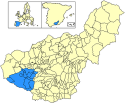
Comarca de Alhama is a comarca in the province of Granada, Spain. The southern portion of the comarca contains the Sierras of Tejeda, Almijara and Alhama Natural Park.[1]
Comarca de Alhama | |
|---|---|
 | |
| Coordinates: 37°2′31″N 3°51′18″W / 37.04194°N 3.85500°W | |
| Country | Spain |
| Autonomous community | Andalusia |
| Province | Granada |
| Area | |
• Total | 974.71 km2 (376.34 sq mi) |
| Population (2023)[note 1] | |
• Total | 16,418 |
| • Density | 17/km2 (44/sq mi) |
Municipalities
editIt contains the following municipalities:[2]
| Arms | Municipality | Area (km2) | Population (2023)[3][note 2] | Density (/km2) |
|---|---|---|---|---|
| Agrón | 27 | 239 | 8.85 | |
| Alhama de Granada | 433.23 | 5,655 | 13.05 | |
| Arenas del Rey | 90.91 | 617 | 6.79 | |
| Cacín | 39.60 | 527 | 13.31 | |
| Chimeneas | 90.27 | 1,238 | 13.71 | |
| Escúzar | 46.39 | 841 | 18.13 | |
| Fornes | 15.14 | 543 | 35.87 | |
| Játar | 9.57 | 582 | 60.82 | |
| Jayena | 80 | 993 | 12.41 | |
| La Malahá | 25.42 | 1,845 | 72.58 | |
| Santa Cruz del Comercio | 16.88 | 530 | 31.40 | |
| Ventas de Huelma | 42.44 | 651 | 15.34 | |
| Zafarraya | 57.86 | 2,157 | 37.28 | |
| Total | 974,71 | 16,418 | 16.84 |
Notes
edit- ^ Estimate at 1 January 2023: National Statistics Institute (Spain).
- ^ Estimate at 1 January 2023: National Statistics Institute (Spain).
References
edit- ^ "Alhama de Granada, Granada, Spain". Google Maps. Retrieved 2017-12-25.
- ^ "Alhama". www.geopostcodes.com. Retrieved 2017-12-25.
- ^ "Granada: Population by municipality and sex. (2871)". INE. Retrieved 2024-09-21.