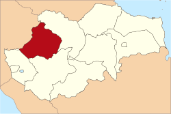
Bungo Regency is a regency (kabupaten) of Jambi Province in Sumatra, Indonesia. It was created on 4 October 1999 by the division of the former Bungo Tebo Regency into a new Tebo Regency in the west and this Bungo Regency in the east. The Bungo Regency covers an area of 4,659 km2.[2] As at the 2010 census, the regency had a population of 303,135[3] and 362,363 at the 2020 census;[4] the official estimate as at mid 2023 was 376,382 - comprising 191,594 males and 184,788 females.[1] The administrative capital is the town of Muara Bungo.
Bungo Regency | |
|---|---|
| Motto(s): Langkah Serentak Limbah Seayun (Stepping together, swaying together) | |
 | |
| Country | Indonesia |
| Province | Jambi |
| Regency seat | Muara Bungo |
| Area | |
• Total | 4,659.00 km2 (1,798.85 sq mi) |
| Population (mid 2023 estimate)[1] | |
• Total | 376,382 |
| • Density | 81/km2 (210/sq mi) |
| Time zone | UTC+7 |
| Website | bungokab.go.id |
Administrative districts
editBungo Regency is subdivided into seventeen districts (kecamatan), listed below with their areas and their populations at the 2010 census[3] and the 2020 census,[4] together with the official estimates as at mid 2023.[1] The table also includes the locations of the district administrative centres, the number of villages in each district (a total of 141 rural desa and 12 urban kelurahan), and its post code.
| Kode Wilayah |
Name of District (kecamatan) |
Area in km2 |
Pop'n census 2010 |
Pop'n census 2020 |
Pop'n estimate mid 2023 |
Admin centre |
No. of villages |
Post code |
|---|---|---|---|---|---|---|---|---|
| 15.08.06 | Pelepat | 1,069.07 | 27,718 | 35,260 | 37,160 | Rantau Keloyang | 15 | 37262 |
| 15.08.09 | Pelepat Ilir | 410.29 | 44,479 | 51,212 | 52,430 | Kuamang Jaya | 17 | 37252 |
| 15.08.10 | Bathin II Babeko | 176.29 | 10,533 | 14,268 | 15,310 | Simpang Babeko | 6 | 37210 |
| 15.08.13 | Rimbo Tengah | 96.90 | 23,760 | 32,764 | 35,340 | Cadika | 4 (a) | 37215 |
| 15.08.12 | Bungo Dani | 35.97 | 23,208 | 27,436 | 28,300 | Talang Pantai | 5 (b) | 37212 |
| 15.08.03 | Pasar Muara Bungo | 9.21 | 22,266 | 21,243 | 21,290 | Bungo Timur | 5 (c) | 37214 |
| 15.08.11 | Bathin III | 80.46 | 18,714 | 26,200 | 28,390 | Manggis | 8 (d) | 37211 |
| 15.08.02 | Rantau Pandan | 239.61 | 9,361 | 10,631 | 10,840 | Rantau Pandan | 6 | 37261 |
| 15.08.08 | Muko-Muko Bathin VII | 186.73 | 13,386 | 15,412 | 15,780 | Tanjung Agung | 9 | 37216 |
| 15.08.14 | Bathin III Ulu | 373.83 | 7,833 | 9,609 | 10,020 | Muara Buat | 9 | 37260 |
| 15.08.05 | Tanah Sepenggal | 106.92 | 20,580 | 24,376 | 25,160 | Pasar Lubuk Landai | 10 | 37263 |
| 15.08.17 | Tanah Sepenggal Lintas | 77.51 | 21,201 | 23,659 | 24,000 | Ambacang Gedang | 12 | 37264 |
| 15.08.01 | Tanah Tumbuh | 236.55 | 13,268 | 15,140 | 15,460 | Tanah Tumbuh | 11 | 37255 |
| 15.08.07 | Limbur Lubuk Mengkuang | 932.41 | 14,036 | 16,713 | 17,280 | Tuo Limbur | 14 | 37213 |
| 15.08.15 | Bathin II Pelayang | 179.84 | 8,420 | 9,042 | 9,070 | Pelayang | 5 | 37254 |
| 15.08.04 | Jujuhan | 254.12 | 14,656 | 19,112 | 20,290 | Rantau Ikil | 10 | 37256 |
| 15.08.16 | Jujuhan Ilir | 193.04 | 9,716 | 10,286 | 10,280 | Pulau Batu | 7 | 37257 |
| Total Regency | 4,659.00 | 303,135 | 362,363 | 376,382 | Muara Bungo | 153 |
Notes: (a) including 2 kelurahan - Cadika and Pasir Putih. (b) including 2 kelurahan - Sungai Kerjan and Sungai Pinang.
(c) all 5 are kelurahan - Batang Bungo, Bungo Barat, Bungo Timur, Jaya Setia and Tanjung Gedang.
(d) including 3 kelurahan - Bungo Taman Agung, Manggis and Sungai Binjai.
Muara Bungo Airport
editMuara Bungo Airport with a 1,350 metre runway has flight routes to Jakarta, Jambi, and Bengkulu.[5]
References
edit- ^ a b c Badan Pusat Statistik, Jakarta, 28 February 2024, Kabupaten Bungo Dalam Angka 2024 (Katalog-BPS 1102001.1508)
- ^ "Website Resmi Pemerintah Kabupaten Bungo". bungokab.go.id. Bungo Regency. 2011. Retrieved 2011-02-10.
- ^ a b Biro Pusat Statistik, Jakarta, 2011.
- ^ a b Barat Pusat Statistik, Jakarta, 2021.
- ^ "Pesawat AviaStar Mendarat Perdana di Bandara Muara Bungo". December 19, 2012. Archived from the original on December 26, 2012. Retrieved January 8, 2013.
