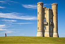
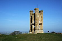
Broadway Tower is an 18th-century folly near the village of Broadway, in the English county of Worcestershire. It is a Grade II listed building.[1]


The tower is built of limestone ashlar and is four storeys high, hexagonal, with three round corner turrets,[a] battlements and gargoyles.[1] It stands above the village of Broadway on Broadway Hill, the second-highest point of the Cotswolds, at an elevation of 1,024 feet (312 m).[2][3] The tower itself is 65 feet (20 m) tall.[3] Although a folly, it is a functional building with interior rooms, the top three floors being used as a museum. The rooftop viewing platform can be accessed for good views.[4] Two of the turrets each contain a spiral staircase leading from the ground to the roof.
The tower is on the Cotswold Way, and can be reached by following this footpath from the A44 road at Fish Hill, or by a steep climb out of Broadway village. It is now the centre of Broadway Tower Country Park, which has exhibitions open to the public for a fee, as well as a gift shop and restaurant.[4]
History
editThe Saxon-style tower was the brainchild of landscaper Capability Brown, designed by architect James Wyatt in 1794[3][5] in the form of a castle, and built by the 6th Earl of Coventry for his wife Barbara in 1798–1799. Broadway Hill was a beacon hill, where beacons were lit on special occasions. The tower was just visible from the Coventrys' home at Croome Court in south Worcestershire,[4] about 15 miles (24 km) to the north-west, past the north escarpment of Bredon Hill. One theory for its construction says that Lady Coventry wondered if a beacon on the hill could be seen from her house. Another is that it served to signal to the Croome Court staff that the earl and his wife were returning from their Spring Hill estate.[6]
From 1822 to 1862, the tower housed the private printing press of Sir Thomas Phillipps.[1] By the mid-1870s, it was being rented by C. J. Stone and Cormell Price.[7] Price was headmaster of the United Services College at Westward Ho! and a friend of artists William Morris, Edward Burne-Jones, and Dante Gabriel Rossetti; in 1876 Morris wrote in a letter to Aglaia Coronio that he was "today at Crom Price's Tower among the winds and the clouds".[8]
Near the tower is a memorial to the crew of an A.W.38 Whitley bomber that crashed there during a training mission in June 1943.
In the late 1950s, an underground Royal Observer Corps monitoring post was built nearby. It was decommissioned in 1991, but has been restored, and is now one of the few such Cold War monitoring facilities in England still extant and accessible to visitors.[9]
Notes
editReferences
edit- ^ a b c "Broadway Tower". Historic England. Retrieved 9 September 2024. It refers to Cormell Price as "Camel Price, an Oxford tutor".
- ^ "Broadway Tower & Park". Broadway Tower. Retrieved 9 September 2024.
- ^ a b c "History of Broadway Tower". Visit Broadway. 2 January 2016. Retrieved 9 September 2024.
- ^ a b c "Broadway Tower Country Park". Broadway Cotswolds. Retrieved 9 September 2024.
- ^ Colvin, Howard (1995). A Biographical Dictionary of British Architects 1600-1840 (3rd ed.). New Haven and London: Yale University Press. p. 1118. ISBN 0-300-06091-2.
drawings by Wyatt dated 1794 in Estate Office, Croome
- ^ "Broadway Tower: Thank Goodness for English Folly". Sat Nav and Cider. 26 September 2012. Retrieved 19 September 2024.
- ^ Price, Lorraine (1983). "Cormell Price Esq., The Tower, Broadway" (PDF). The Journal of the William Morris Society. 5 (4): 30–39. ISSN 1756-1353. Archived (PDF) from the original on 8 March 2024. Retrieved 9 September 2024.
- ^ MacCarthy, Fiona (1994). William Morris: a Life for Our Time. Alfred A. Knopf Inc. p. 370. ISBN 0-394-58531-3.
- ^ Stilliard, Ed (25 February 2023). "The nuclear bunker under a Cotswolds landmark you can actually visit". Gloucestershire Live. Retrieved 9 September 2024.
External links
edit- Media related to Broadway Tower at Wikimedia Commons
- Official website