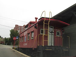
Bridgeville is a borough in Allegheny County, Pennsylvania, United States. The population was 4,804 at the 2020 census.[3] It is a residential suburb of the Pittsburgh metropolitan area.
Bridgeville, Pennsylvania | |
|---|---|
 | |
| Etymology: Bridge over Chartiers Creek | |
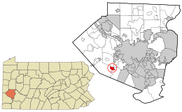
 Location in Allegheny County and the U.S. state of Pennsylvania. | |
| Coordinates: 40°21′25″N 80°06′31″W / 40.35694°N 80.10861°W | |
| Country | United States |
| State | Pennsylvania |
| County | Allegheny |
| Settled | c. 1830 |
| Incorporated | July 27, 1901 |
| Government | |
| • Mayor | Betty Copeland (D) |
| Area | |
• Total | 1.10 sq mi (2.84 km2) |
| • Land | 1.09 sq mi (2.84 km2) |
| • Water | 0.00 sq mi (0.00 km2) |
| Elevation | 820 ft (250 m) |
| Population | |
• Total | 4,804 |
| • Density | 4,387.21/sq mi (1,693.68/km2) |
| Time zone | UTC-5 (EST) |
| • Summer (DST) | UTC-4 (EDT) |
| ZIP code | 15017 |
| Area code | 412 |
| FIPS code | 42-08624 |
| School district | Chartiers Valley |
| Website | www |
History
editThe village that eventually became Bridgeville acquired its name because of the first bridge built at the crossing of Chartiers Creek at the south end of what is now Washington Avenue.[4]
The area was originally named St. Clair Township in 1763, and the southern part was split off as Upper St. Clair Township in 1806. For nearly 100 years, Bridgeville was a village within Upper St. Clair Township, known for its one bridge over Chartiers Creek where people frequently met to trade goods. An old saying, "Meet me at the bridge," provided an obvious name for the village that began to develop north of the bridge[5] around 1830.[6]
Mining operations began in the 1880s, prompting growth.[7] Bridgeville was officially incorporated as a borough on July 27, 1901, from Upper St. Clair Township.[6]
A mass shooting took place on August 4, 2009, in an LA Fitness health club near Bridgeville in Collier Township. The attack resulted in four deaths, including that of the perpetrator, who took his own life. Nine other people were injured.[8]
Geography
editBridgeville is located along Chartiers Creek, about 8 miles (13 km) southwest of downtown Pittsburgh at 40°21′25″N 80°6′31″W / 40.35694°N 80.10861°W.[9]
According to the United States Census Bureau, the borough has a total area of 1.1 square miles (2.8 km2), all land. Its average elevation is 1,250 ft (381 m) above sea level.[10]
McLaughlin Run, a tributary to Chartiers Creek, flows through Bridgeville.
Surrounding communities
editBridgeville has three borders with the townships of Collier to the north and northwest, South Fayette to the west and southwest, and Upper St. Clair to the south, southeast and east.
Demographics
edit| Census | Pop. | Note | %± |
|---|---|---|---|
| 1880 | 147 | — | |
| 1910 | 1,983 | — | |
| 1920 | 3,092 | 55.9% | |
| 1930 | 3,939 | 27.4% | |
| 1940 | 4,459 | 13.2% | |
| 1950 | 5,650 | 26.7% | |
| 1960 | 7,112 | 25.9% | |
| 1970 | 6,717 | −5.6% | |
| 1980 | 6,154 | −8.4% | |
| 1990 | 5,445 | −11.5% | |
| 2000 | 5,341 | −1.9% | |
| 2010 | 5,148 | −3.6% | |
| 2020 | 4,804 | −6.7% | |
| Sources:[11][12][13][14][15][2] | |||
As of the census[14] of 2000, there were 5,341 people, 2,539 households, and 1,444 families residing in the borough. The population density was 4,938.5 people per square mile (1,906.8 people/km2). There were 2,656 housing units at an average density of 2,455.9 per square mile (948.2/km2). The racial makeup of the borough was 94.05% White, 4.42% African American, 0.09% Native American, 0.37% Asian, 0.34% from other races, and 0.73% from two or more races. Hispanic or Latino of any race were 0.77% of the population.
There were 2,539 households, out of which 20.8% had children under the age of 18 living with them, 43.6% were married couples living together, 10.1% had a female householder with no husband present, and 43.1% were non-families. 39.5% of all households were made up of individuals, and 21.4% had someone living alone who was 65 years of age or older. The average household size was 2.09 and the average family size was 2.81.
In the borough the population was spread out, with 18.0% under the age of 18, 5.6% from 18 to 24, 28.4% from 25 to 44, 22.2% from 45 to 64, and 25.8% who were 65 years of age or older. The median age was 44 years. For every 100 females, there were 86.9 males. For every 100 females age 18 and over, there were 82.3 males.
The median income for a household in the borough was $34,873, and the median income for a family was $46,500. Males had a median income of $35,461 versus $25,527 for females. The per capita income for the borough was $19,500. About 5.6% of families and 7.8% of the population were below the poverty line, including 6.6% of those under age 18 and 12.0% of those age 65 or over.
Government and politics
edit| Year | Republican | Democratic | Third Parties |
|---|---|---|---|
| 2020 | 48% 1,374 | 50% 1,447 | 1% 37 |
| 2016 | 48% 1,181 | 47% 1,155 | 5% 127 |
| 2012 | 50% 1,149 | 49% 1,137 | 1% 24 |
Education
editBridgeville is served by the Chartiers Valley School District. The public school serves students from Bridgeville, Collier, Scott, and Heidelberg.
Notable people
edit- Paul Danilo, member of the Soccer Hall of Fame
- Nicholas DiOrio, member of the Soccer Hall of Fame
- C.J. Henderson, author
- Eric Kush, NFL player
- T. J. McConnell, NBA player
- Ron Sams, NFL player
- Harold Stephens, writer and novelist
- Justin Watson, NFL player
- Madison Campbell, CEO and founder of Leda Health[19]
References
edit- ^ "ArcGIS REST Services Directory". United States Census Bureau. Retrieved October 12, 2022.
- ^ a b "Census Population API". United States Census Bureau. Retrieved Oct 12, 2022.
- ^ "Explore Census Data".
- ^ "Welcome to Bridgeville". Retrieved 2007-11-25.
- ^ "A Brief History of Bridgeville". Archived from the original on 2009-10-25. Retrieved 2007-11-25.
- ^ a b "Allegheny County - 2nd Class" (PDF). Retrieved 2007-11-25.
- ^ Ackerman, Jan (May 10, 1984). "Town names carry bit of history". Pittsburgh Post-Gazette. p. 6. Retrieved 31 October 2015.
- ^ "4 Dead In Collier Township Gym Shooting; Gunman Kills Self, Officials Say". Internet Broadcasting Systems, Inc. August 4, 2009. p. 1. Archived from the original on August 14, 2009. Retrieved 2009-08-05.
- ^ "US Gazetteer files: 2010, 2000, and 1990". United States Census Bureau. 2011-02-12. Retrieved 2011-04-23.
- ^ "US Board on Geographic Names". United States Geological Survey. 2007-10-25. Retrieved 2008-01-31.
- ^ "Number and Distribution of Inhabitants:Pennsylvania-Tennessee" (PDF). Fifteenth Census. U.S. Census Bureau.
- ^ "Number of Inhabitants: Pennsylvania" (PDF). 18th Census of the United States. U.S. Census Bureau. Retrieved 22 November 2013.
- ^ "Pennsylvania: Population and Housing Unit Counts" (PDF). U.S. Census Bureau. Retrieved 22 November 2013.
- ^ a b "U.S. Census website". United States Census Bureau. Retrieved 2008-01-31.
- ^ "Annual Estimates of the Resident Population". U.S. Census Bureau. Archived from the original on 2013-10-19. Retrieved 22 November 2013.
- ^ EL. "2012 Allegheny County election". Pittsburgh Tribune-Review. Retrieved 15 October 2017.
- ^ EL. "2016 Pennsylvania general election results". Pittsburgh Post-Gazette. Retrieved 15 October 2017.
- ^ "Election Night Reporting".
- ^ Ritenbaugh, Stephanie (2023-10-24). "Tech startup for sexual assault survivors moves to Lawrenceville". TribLIVE.com. Retrieved 2023-10-26.