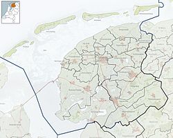
Bitgummole (Dutch: Beetgumermolen[3]) is a village in Waadhoeke municipality in the province of Friesland, the Netherlands. It had a population of around 911 in January 2017.[4] Before 2018, the village was part of the Menameradiel municipality.[5]
Bitgummole
Beetgumermolen | |
|---|---|
Village | |
 Bitgummole church | |
 Location in Menameradiel municipality | |
| Coordinates: 53°14′6″N 5°42′19″E / 53.23500°N 5.70528°E | |
| Country | Netherlands |
| Province | Friesland |
| Municipality | Waadhoeke |
| Area | |
• Total | 5.11 km2 (1.97 sq mi) |
| Elevation | 1.3 m (4.3 ft) |
| Population (2021)[1] | |
• Total | 910 |
| • Density | 180/km2 (460/sq mi) |
| Postal code | 9045[1] |
| Dialing code | 058 |
History
editThe village was first mentioned in 1622 as Beetgumer Meulen, and means "wind mill of Beetgum". The mill was a grist mill for rye which has been known to exist on the dike since the 16th century.[6] Bitgummole was built on a dike from around 1300.[5] It started to develop during the 18th and 19th century. A church was built in 1924.[7]
Bitgummole was home to 494 people in 1840. The wind mill burnt down in 1862, and was never rebuilt.[5] In 1963, it was awarded village status.[5]
References
edit- ^ a b c "Kerncijfers wijken en buurten 2021". Central Bureau of Statistics. Retrieved 4 April 2022.
- ^ "Postcodetool for 9045PA". Actueel Hoogtebestand Nederland (in Dutch). Het Waterschapshuis. Retrieved 4 April 2022.
- ^ Taalunie (2019). "Friese namen" (in Dutch). Retrieved 18 November 2019.
- ^ Feiten en cijfers - Menameradiel
- ^ a b c d "Bitgummole". Plaatsengids (in Dutch). Retrieved 4 April 2022.
- ^ "Beetgumermolen - (geografische naam)". Etymologiebank (in Dutch). Retrieved 4 April 2022.
- ^ Ronald Stenvert & Sabine Broekhoven (2000). "Beetgum" (in Dutch). Zwolle: Waanders. ISBN 90 400 9476 4. Retrieved 4 April 2022.

