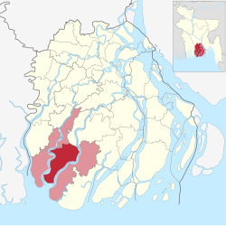
Barguna Sadar (Bengali: বরগুনা সদর) is an upazila of Barguna District[4] in the Division of Barisal, Bangladesh.
Barguna Sadar
বরগুনা সদর | |
|---|---|
 | |
| Coordinates: 22°9′N 90°7.6′E / 22.150°N 90.1267°E | |
| Country | |
| Division | Barisal Division |
| District | Barguna District |
| Headquarters | Barguna |
| Government | |
| • Upazila Chairman | Muhammad Munirul Islam |
| • MP (Barguna-1) | Dhirendra Debnath Shambhu |
| Area | |
• Total | 454.38 km2 (175.44 sq mi) |
| Population | |
• Total | 294,375 |
| • Density | 650/km2 (1,700/sq mi) |
| Time zone | UTC+6 (BST) |
| Postal code | 8700[2] |
| Area code | 0448[3] |
| Website | Official Map of the Barguna Sadar Upazila |
Geography
editBarguna Sadar is located at 22°09′03″N 90°07′35″E / 22.1508°N 90.1264°E. It has a total area of 454.39 km2.
History
editIn 1904, a thana (police outpost headquarters) was founded in Barguna. During the Bangladesh Liberation War of 1971, many people were murdered in Barguna town as well as the Bengali freedom fighters when retreating. 100 prisoners at the Barguna Jail were killed by the Pakistan Army on 29 and 30 November and they were later buried in a mass grave to the west of the Jail. By 3 December, Barguna had been liberated.[4] Barguna Sadar Thana's status was upgraded to upazila (sub-district) in 1983 as part of the President of Bangladesh Hussain Muhammad Ershad's decentralisation programme.
Demographics
editAccording to the 2011 Census of Bangladesh, Barguna Sadar Upazila had a population of 260,830 living in 62,086 households. 56,337 (21.56%) were under 10 years of age. Barguna Sadar has a literacy rate (age 7 and over) of 58.6%, compared to the national average of 51.8%, and a sex ratio of 1036 females per 1000 males. 32,235 (12.36%) lived in urban areas.[6][7]
According to the 1991 Bangladesh census, Barguna Sadar had a population of 219,729. Males constituted 50.7% of the population, and females 49.3%. The population aged 18 or over was 111,209. Barguna Sadar had an average literacy rate of 90.8% (7+ years), compared to the national average of 72.4%.[8] Majority of its residents are Barisali Bengali Muslims, though there is a substantial population of Barisali Bengali Hindus as well as a minority Rakhine Buddhist community in Baliatali Union.[9]
Administration
editUNO: Md. Shamim Mia.[10]
Barguna Sadar Upazila is divided into Barguna Municipality and ten union parishads: Aylapatakata, Barguna, Bodorkhali, Burirchor, Dhalua, Fuljhuri, Gowrichanna, Keorabunia, M. Baliatali, and Noltona. The union parishads are subdivided into 51 mauzas and 191 villages.[11]
Barguna Municipality is subdivided into 9 wards and 18 mahallas.[11]
See also
editReferences
edit- ^ National Report (PDF). Population and Housing Census 2022. Vol. 1. Dhaka: Bangladesh Bureau of Statistics. November 2023. p. 395. ISBN 978-9844752016.
- ^ "Bangladesh Postal Code". Dhaka: Bangladesh Postal Department under the Department of Posts and Telecommunications of the Ministry of Posts, Telecommunications and Information Technology of the People's Republic of Bangladesh. 21 October 2024.
- ^ "Bangladesh Area Code". China: Chahaoba.com. 18 October 2024.
- ^ a b Safi Uddin Ahmed (2012). "Barguna Sadar Upazila". In Sirajul Islam; Miah, Sajahan; Khanam, Mahfuza; Ahmed, Sabbir (eds.). Banglapedia: the National Encyclopedia of Bangladesh (Online ed.). Dhaka, Bangladesh: Banglapedia Trust, Asiatic Society of Bangladesh. ISBN 984-32-0576-6. OCLC 52727562. OL 30677644M. Retrieved 25 December 2024.
- ^ Population and Housing Census 2022 - District Report: Barguna (PDF). District Series. Dhaka: Bangladesh Bureau of Statistics. June 2024. ISBN 978-984-475-223-8.
- ^ "Community Report: Barguna" (PDF). Population & Housing Census 2011. Bangladesh Bureau of Statistics. Retrieved 15 August 2018.
- ^ "Bangladesh Population & Housing Census-2011, Zila Report: Barguna" (PDF). Bangladesh Bureau of Statistics. p. 18.
- ^ "Population Census Wing, BBS". Archived from the original on 2005-03-27. Retrieved November 10, 2006.
- ^ ভাষা ও সংষ্কৃতি [Language and culture]. Borguna Shodor Upazila (in Bengali).
- ^ উপজেলা নির্বাহী অফিসার. 2024-08-26. Archived from the original on 2024-08-26.
- ^ a b "District Statistics 2011: Barguna" (PDF). Bangladesh Bureau of Statistics. Archived from the original (PDF) on 13 November 2014. Retrieved 14 July 2014.