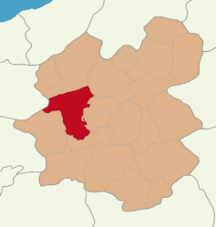
Aziziye is a municipality and district of Erzurum Province, Turkey.[2] Its area is 1,529 km2,[3] and its population is 65,553 (2022).[1]
Aziziye | |
|---|---|
District and municipality | |
 | |
 Map showing Aziziye District in Erzurum Province | |
| Coordinates: 39°57′N 41°06′E / 39.950°N 41.100°E | |
| Country | Turkey |
| Province | Erzurum |
| Government | |
| • Mayor | Emrullah Akpunar (AKP) |
Area | 1,529 km2 (590 sq mi) |
| Elevation | 1,760 m (5,770 ft) |
| Population (2022)[1] | 65,553 |
| • Density | 43/km2 (110/sq mi) |
| Time zone | UTC+3 (TRT) |
| Postal code | 25700 |
| Area code | 0442 |
| Climate | Dfb |
The district was established as Ilıca District in 1990, with its centre at Ilıca.[4][5] It was expanded with the former municipality Dadaşkent and renamed to Aziziye in 2008.[6] Aziziye lies in the western part of the urban area of Erzurum. The district center is famous for thermal springs (39.4 oC).
The majority of the district is populated by Turks (98%) with a small minority of Karapapakhs, Kurds, Hemshins and Meskhetian Turks.
Demographics
editEthnic groups
editTotal population (2022 census): 65,553
By ethnic settlements (2022 census):[7]
- Turks: 64,042 (98%)
- Karapapakhs: 658 (1%)
- Kurds: 435 (0.5%)
- Hemshins: 371 (0.4%)
- Meskhetian Turks: 47 (0.1%)
The town centre of Aziziye is predominantly Turkish (>95%), with a very small Kurdish community.
Composition
editThere are 71 neighbourhoods in Aziziye District:[8]
- Adaçay
- Ağcakent
- Ağören
- Ahırcık
- Akdağ
- Akyazı
- Alaca
- Alaybeyi
- Aşağıcanören
- Aşağıyenice
- Atlıkonak
- Aynalıkale
- Başçakmak
- Başkent
- Başkurtdere
- Başovacık
- Beypınarı
- Bingöze
- Çamlıca
- Çatak
- Çavdarlı
- Çavuşoğlu
- Çiğdemli
- Çıkrıklı
- Dağdagül
- Demirgeçit
- Düztoprak
- Eğerti
- Elmalı
- Emrecik
- Eşkinkaya
- Eskipolat
- Gelinkaya
- Geyik
- Güllüce
- Halilkaya
- Ilıca
- Kabaktepe
- Kahramanlar
- Kapılı
- Karakale
- Kavaklıdere
- Kayapa
- Kızılkale
- Kumluyazı
- Kuşçu
- Kuzgun
- Kuzuluk
- Ocak
- Ömertepe
- Özbek
- Özbilen
- Paşayurdu
- Rizekent
- Sakalıkesik
- Saltuklu
- Sarıyazla
- Selçuklu
- Sırlı
- Söğütlü
- Sorkunlu
- Taşpınar
- Tebrizcik
- Tınazlı
- Toprakkale
- Üçköşe
- Yarımca
- Yeşilova
- Yeşilvadi
- Yoncalık
- Yukarıcanören
References and notes
edit- ^ a b "Address-based population registration system (ADNKS) results dated 31 December 2022, Favorite Reports" (XLS). TÜİK. Retrieved 12 July 2023.
- ^ Büyükşehir İlçe Belediyesi, Turkey Civil Administration Departments Inventory. Retrieved 12 July 2023.
- ^ "İl ve İlçe Yüz ölçümleri". General Directorate of Mapping. Retrieved 12 July 2023.
- ^ Kanun No. 3644, Resmî Gazete, 20 May 1990.
- ^ "İl İdaresi ve Mülki Bölümler Şube Müdürlüğü İstatistikleri - İl ve İlçe Kuruluş Tarihleri" (PDF) (in Turkish). p. 33. Retrieved 30 August 2023.
- ^ Kanun No. 5747, Resmî Gazete, 22 March 2008.
- ^ Nişanyan, S. "Nişanyan Yeradları - Türkiye ve Çevre Ülkeler Yerleşim Birimleri Envanteri". Nişanyan Yeradları (in Turkish). Retrieved 9 January 2025.
- ^ Mahalle, Turkey Civil Administration Departments Inventory. Retrieved 12 July 2023.
