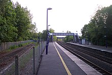
Aldermaston railway station serves the village of Aldermaston in Berkshire, England. The station is at nearby Aldermaston Wharf and about 2 miles (3 km) north of Aldermaston village. It is 44 miles 63 chains (44.79 miles, 72.08 km) measured from London Paddington.
 The station from the footbridge, with a Network Turbo train of First Great Western passing through. | |||||
| General information | |||||
| Location | Aldermaston Wharf, West Berkshire England | ||||
| Grid reference | SU601673 | ||||
| Managed by | Great Western Railway | ||||
| Platforms | 2 | ||||
| Other information | |||||
| Station code | AMT | ||||
| Classification | DfT category F1 | ||||
| History | |||||
| Original company | Great Western Railway | ||||
| Pre-grouping | GWR | ||||
| Post-grouping | GWR | ||||
| Key dates | |||||
| 21 December 1847 | opened | ||||
| Passengers | |||||
| 2019/20 | |||||
| 2020/21 | |||||
| 2021/22 | |||||
| 2022/23 | |||||
| 2023/24 | |||||
| |||||

It was opened on 21 December 1847.[1]
Description
editAldermaston station is between the A4 road and the settlement of Aldermaston Wharf. It has a flanking platform on each side of the double track line. Each platform has its own independent road access and car park, together with a small shelter. The two platforms are also linked by a footbridge. The Newbury-bound platform is flanked on its offside by a siding, formerly used as a headshunt for access to a nearby freight facility. Since the rebuilding of the A340 bridge over the railway line in 2012, the siding has been defunct.
History
editThe station was built by the Berks and Hants Railway, part of the Great Western Railway and stayed with that company after the Grouping of 1923. The line then became part of the Western Region of British Railways upon the subsequent nationalisation of the railways.
When Sectorisation was introduced, the station was served by Network SouthEast although trains of the Intercity Sector passed on the Reading to Taunton Line which uses the Berks and Hants to Westbury for some long-distance services. This continued until the Privatisation of British Railways.
A 10.5-mile (16.9 km) branch line connecting Aldermaston to the Didcot, Newbury and Southampton Railway (DN&SR) at Burghclere was proposed.[2][3] The line was authorised by an Act of Parliament but never built.[4] This is because the railway finances were loaned by the London and South Western Railway, who stipulated that the DN&SR must relinquish their sole rights to run Southampton-bound services on the line and to also abandon its plans for a link at Aldermaston with the Great Western Railway.[5][6] The proposed route roughly followed the Enborne valley, passing south of Brimpton, before following the Gaily Brook and West Clere Scarp near Kingsclere on to Old Burghclere.[6]
Services
editThe station is served by local services operated by Great Western Railway between Reading and Newbury or Bedwyn. Trains run hourly in both directions on Mondays to Saturdays, and on Sundays service is about every 2 hours. Typical journey times are about 15 minutes to Reading and 16 minutes to Newbury. Passengers for London Paddington must normally change trains at Reading, though there are a small number of weekday peak through trains and a regular service on Sundays.[7]
| Preceding station | National Rail | Following station | ||
|---|---|---|---|---|
| Theale | Great Western Railway Reading - Newbury |
Midgham | ||
References
edit- ^ "Basingstoke Railway History in Maps". Christopher Tolley. Archived from the original on 6 December 2008. Retrieved 19 February 2015.
- ^ Carter, Ernest Frank (1959). An Historical Geography of the Railways of the British Isles. Cassell. p. 414.
- ^ Popplewell, Lawrence (1973). Bournemouth railway history: an exposure of Victorian engineering fraud. Dorset Publishing Co. p. 210.
- ^ Karau, Paul; Parsons, Mike; Robertson, Kevin (1984). An illustrated history of the Didcot, Newbury, and Southampton railway. Upper Bucklebury, Berks.: Wild Swan. pp. viii. ISBN 0906867045.
- ^ Pannell, John Percival Masterman (1969). Old Southampton Shores. David & Charles. p. 139.
- ^ a b "RAILWAY MANIA". Kingsclere: Its History and Its People. Retrieved 4 January 2014.
- ^ Table 116 National Rail timetable, May 2016
Further reading
edit- Butt, R. V. J. (October 1995). The Directory of Railway Stations: details every public and private passenger station, halt, platform and stopping place, past and present (1st ed.). Sparkford: Patrick Stephens Ltd. ISBN 978-1-85260-508-7. OCLC 60251199. OL 11956311M.
- Jowett, Alan (March 1989). Jowett's Railway Atlas of Great Britain and Ireland: From Pre-Grouping to the Present Day (1st ed.). Sparkford: Patrick Stephens Ltd. ISBN 978-1-85260-086-0. OCLC 22311137.
- Jowett, Alan (2000). Jowett's Nationalised Railway Atlas (1st ed.). Penryn, Cornwall: Atlantic Transport Publishers. ISBN 978-0-906899-99-1. OCLC 228266687.
External links
edit- Train times and station information for Aldermaston railway station from National Rail
- Station on navigable O.S. map