This article needs additional citations for verification. (May 2022) |
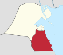
The Ahmadi Governorate[a] is a governorate in southern Kuwait. It is the second most populated governorate in Kuwait, behind Farwaniya Governorate. Many oil and petroleum companies such as KOC and KNPC have their headquarters here.
Ahmadi Governorate
محافظة الأحمدي Muḥāfaẓat al-Aḥmadī | |
|---|---|
 Map of Kuwait with Ahmadi highlighted | |
| Coordinates (Ahmadi): 29°04′37″N 48°05′02″E / 29.077°N 48.084°E | |
| Country | |
| Seat | Ahmadi |
| Districts | 29 |
| Area | |
• Total | 5,120 km2 (1,980 sq mi) |
| Population (June 2014)[1] | |
• Total | 809,353 |
| • Density | 160/km2 (410/sq mi) |
| Time zone | UTC+03 (AST) |
| ISO 3166 code | KW-AH |

Districts
editAhmadi consists of the following districts:[2]
| English | Arabic | Population | Notes/Landmarks |
|---|---|---|---|
| Abu Halifa | أبو حليفة | 29,870 | |
| Mina Abdulla | ميناء عبد الله | 24,415 | |
| Ahmadi | الأحمدي | 21,469 | Governorate seat. |
| Ali Sabah Al-Salem | علي صباح السالم | 42,173 | |
| Egaila | العقيلة | 13,579 | |
| Bar Al-Ahmadi | بر الأحمدي | 723 | Desert area of Al Ahmadi. |
| Bnaider | بنيدر | ||
| Dhaher | الظهر | 33,197 | |
| Fahaheel | الفحيحيل | 54,157 | |
| Fahad Al-Ahmad | فهد الأحمد | 17,096 | |
| Hadiya | هدية | 17,990 | |
| Jaber Al-Ali | جابر العلي | 38,868 | |
| Al-Julaia'a | الجليعة | ||
| Khairan | الخيران | 1,895 | |
| Mahboula | المهبولة | 77,988 | |
| Mangaf | المنقف | 73,378 | |
| Magwa | المقوع | 32 | |
| Wafra Residential | وفرة السكنية | 2,488 | |
| Al-Nuwaiseeb | النويصيب | 537 | |
| Riqqa | الرقة | 36,058 | |
| Sabah Al Ahmad | صباح الاحمد | ||
| Sabah Al Ahmad Sea City | مدينة صباح الأحمد البحرية | ||
| Sabahiya | الصباحية | 56,640 | |
| Shuaiba Industrial | الشعيبة | 26 | |
| South Sabahiya | جنوب الصباحية | 73 | |
| Wafra | الوفرة | 7,856 | |
| Zoor | الزور | 2,230 | |
| Fintas | الفنطاس | ||
| Al Shadadiya Industrial | الشدادية الصناعية | ||
| Total population (2011) | 588,068 | ||
Government
editJabir Abdallah Jabir Abdallah II served as governor 1962–1985.[3]
Notes
editReferences
edit- ^ "Statistical Reports". Archived from the original on 2014-03-13. Retrieved 2014-09-02.
- ^ Kuwait Map
- ^ Alan Rush (1987). Al-Sabah: History & Genealogy of Kuwait's Ruling Family, 1752-1987. London: Ithaca Press. ISBN 978-0-86372-081-9.
