Abernethy is a small town in the City of Cessnock, in the Hunter Region in the state of New South Wales, Australia. Abernethy is located 8 kilometres south-east of the town of Cessnock, NSW and is adjacent to Werakata National Park and the Aberdare State Forest. The town was founded near a coal mine and some of the historic buildings remain (including the Abernethy Hotel which now operates as a guest house). In 2016 348 lived there with the median age being 32 and 74.8% being born in Australia.[16]
| Abernethy City of Cessnock, New South Wales | |||||||||||||||
|---|---|---|---|---|---|---|---|---|---|---|---|---|---|---|---|
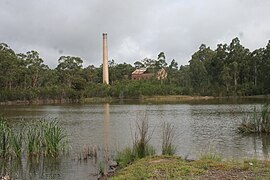
 Remains of old Aberdare South Colliery | |||||||||||||||
| Coordinates | 32°52′12″S 151°24′00″E / 32.87000°S 151.40000°E[1] | ||||||||||||||
| Population | 317 (SAL 2021)[2] | ||||||||||||||
| Established | 1913[3] | ||||||||||||||
| Gazetted | 14 July 1915 (village)[4] 5 September 1975 (village)[5] 23 October 2015 (locality)[6] | ||||||||||||||
| Postcode(s) | 2325[7] | ||||||||||||||
| Elevation | 90 m (295 ft)[8] | ||||||||||||||
| Area | 8.4025 km2 (3.2 sq mi)[9] | ||||||||||||||
| Time zone | AEST[10] (UTC+10) | ||||||||||||||
| • Summer (DST) | AEDT[11] (UTC+11) | ||||||||||||||
| Location | |||||||||||||||
| LGA(s) | Cessnock[12] | ||||||||||||||
| Region | Hunter | ||||||||||||||
| County | Northumberland[12] | ||||||||||||||
| Parish | Cessnock[12] | ||||||||||||||
| State electorate(s) | Cessnock[13] | ||||||||||||||
| Federal division(s) | Hunter[14] | ||||||||||||||
| |||||||||||||||
| |||||||||||||||
Mining history
editThe town's origins lie in the establishment of the Aberdare South Colliery which was operated by Caledonian Collieries Limited.[17] The town was laid out in 1906 and the mine commenced operation in 1913. The mine closed in 1927.[18]
Some structures of the old Colliery are still present on the site including the winder house, the chimney stack and dam.
Population
editIn 2016 the population is 348 and the median age is 32.[19] 74.8% were born in Australia and 2.1% were born in England.[16] 26.0% were Anglican, 22.5% mot stated, 20.8% no religion, 13.9% Catholic and 7.2% Presbyterian and Reformed.[16] 79.65 only spoke English at home.[19]
Bushfire in 2002
editOn 19 October 2002, a large bushfire in Abernethy claimed the life of Sydney businessman Ronald Gillett, destroyed six homes and damaged many more.
A 2004 inquest found that the fire was deliberately lit "by persons unknown". A subsequent inquest reached a similar conclusion in 2008.[20] In February 2010, Police announced a $100,000 reward for information that leads to the arrest of the arsonist.[21]
See also
editReferences
edit- ^ "Abernethy (NSW80833)". Gazetteer of Australia online. Geoscience Australia, Australian Government.
- ^ Australian Bureau of Statistics (28 June 2022). "Abernethy (suburb and locality)". Australian Census 2021 QuickStats. Retrieved 28 June 2022.
- ^ "Cessnock Shire Council". The Maitland Daily Mercury. No. 13, 203. New South Wales, Australia. 10 July 1913. p. 4. Retrieved 4 January 2018 – via National Library of Australia.
- ^ "Village of Abernethy". Government Gazette Of The State Of New South Wales. No. 127. New South Wales, Australia. 14 July 1915. p. 4156. Retrieved 4 January 2018 – via National Library of Australia.
- ^ "Geographical Names Act, 1966". Government Gazette Of The State Of New South Wales. No. 114. New South Wales, Australia. 5 September 1975. p. 3623. Retrieved 29 December 2017 – via National Library of Australia.
- ^ "Geographical Names Act, 1966" (PDF). Government Gazette Of The State Of New South Wales. No. 91. New South Wales, Australia. 23 October 2015. p. 3403. Retrieved 3 January 2018 – via NSW Legislation.
- ^ "Abernethy Postcode, NSW - Australia Post". Australia Post. Retrieved 3 January 2018.
- ^ "Map of Aberdare in New South Wales". Bonzle Digital Atlas of Australia. Retrieved 2 January 2018.
- ^ Australian Bureau of Statistics (13 September 2016). Australian Statistical Geography Standard (ASGS): Volume 3 - Non ABS Structures, July 2016, 'State Suburbs ASGS Edition 2016 in .csv Format', data cube: Excel Spreadsheet, cat. no. 1270.0.55.003 (Report). Australian Bureau of Statistics. Retrieved 3 January 2017.
- ^ Standard Time Act 1987 (NSW) s 3
- ^ Standard Time Act 1987 (NSW) s 4
- ^ a b c "Abernethy (locality)". Geographical Names Register (GNR) of NSW. Geographical Names Board of New South Wales. Retrieved 3 January 2018.
- ^ "Cessnock". NSW Electoral Commission. Archived from the original on 4 January 2018. Retrieved 4 January 2018.
- ^ "Localities". Australian Electoral Commission. Retrieved 3 January 2018.[permanent dead link]
- ^ a b c "Cessnock Airport AWS". Climate statistics for Australian locations. Bureau of Meteorology. Retrieved 29 December 2017.
- ^ a b c "2016 Census QuickStats: Abernethy". quickstats.censusdata.abs.gov.au. Retrieved 23 September 2020.
- ^ "The South Maitland Railway Collieries". Retrieved 9 March 2011.
- ^ "NSW Department of Planning - Major Projects - Austar Coal Mining Project [Socio Economic Assessment]" (PDF). Archived from the original (PDF) on 22 March 2018. Retrieved 4 January 2018.
- ^ a b "2016 Census QuickStats: Abernethy". quickstats.censusdata.abs.gov.au. Retrieved 21 October 2020.
- ^ Ryan, Stephen (21 October 2008), "Coroner criticises first inquest into fatal bushfire", Newcastle Herald, retrieved 3 March 2011
- ^ "NSW Police- $100,000 reward for information about Abernethy bushfire". February 2010. Retrieved 3 March 2011.
- "They called it Siberia : the story of the South Maitland 'coal rush', Aberdare South Colliery and Abernethy village" by Neville Robinson (NLA Catalogue Ref)
External links
edit- "Rural East Precinct" - Cessnock City Council area profile
- Abernethy Guest House
- Photo of old Aberdare South Colliery Buildings
