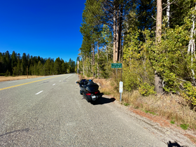
Yuba Pass[1][2] is a mountain pass on State Route 49 in Sierra County in the U.S. state of California. The pass lies at an elevation of 6,710 ft (2,050 m)[1] about 3.4 air miles west of Sattley, on the divide between the North Yuba River and the Middle Fork Feather River (Sierra Valley). Thus, unlike most of the well-known Sierra Nevada passes, including the much lower Beckwourth Pass on the east edge of the Sierra Valley, Yuba Pass does not lie on the Great Basin Divide.
| Yuba Pass | |
|---|---|
 Yuba Pass Sign on CA State Route 49 | |
| Elevation | 6,710 ft (2,045 m)[1] |
| Traversed by | |
| Location | Sierra County, California, U.S. |
| Range | Sierra Nevada |
| Coordinates | 39°37′03″N 120°29′24″W / 39.61750°N 120.49000°W[1] |
| Topo map | USGS Sattley |
Location in California | |
This Yuba Pass should not be confused with Yuba Gap, a minor mountain pass along Interstate 80 on the Nevada-Placer county line.
History
editThis section needs expansion. You can help by adding to it. (June 2022) |
Gallery
editSee also
editReferences
edit- ^ a b c d U.S. Geological Survey Geographic Names Information System: Yuba Pass (Sierra County)
- ^ "Yuba Pass - OHV Parks CA GOV". Retrieved 2022-06-26.
