Yalangur is a rural locality in the Toowoomba Region, Queensland, Australia.[2] In the 2021 census, Yalangur had a population of 55 people.[1]
| Yalangur Queensland | |||||||||||||||
|---|---|---|---|---|---|---|---|---|---|---|---|---|---|---|---|
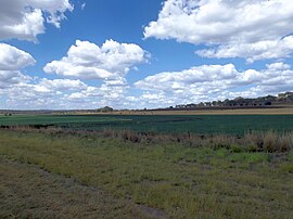
 Fields at Yalangur, 2014 | |||||||||||||||
| Coordinates | 27°25′08″S 151°48′31″E / 27.4188°S 151.8086°E | ||||||||||||||
| Population | 55 (2021 census)[1] | ||||||||||||||
| • Density | 2.191/km2 (5.68/sq mi) | ||||||||||||||
| Postcode(s) | 4352 | ||||||||||||||
| Area | 25.1 km2 (9.7 sq mi) | ||||||||||||||
| Time zone | AEST (UTC+10:00) | ||||||||||||||
| Location |
| ||||||||||||||
| LGA(s) | Toowoomba Region | ||||||||||||||
| State electorate(s) | Condamine | ||||||||||||||
| Federal division(s) | Groom | ||||||||||||||
| |||||||||||||||
Geography
editThe locality is bounded to the north-west by Oakey Creek.[3]
The terrain ranges from 420 to 572 metres (1,378 to 1,877 ft) above sea level with one named peak in the east of the locality, Mcgregor (27°24′41″S 151°51′00″E / 27.4115°S 151.8499°E) at 570 metres (1,870 ft).[3][4]
The land use is predominantly crop growing with some grazing on native vegetation.[5]
History
editThe locality takes its name from its former railway station, which is an Aboriginal word meaning eagle hawk.[2][6]
Haden railway line operated from Kingsthorpe to Haden via Yalangur from 1910 to 1964 with Yalangur railway station just south of the Kelvinhaugh-Yalangur Road (27°25′02″S 151°49′28″E / 27.41710°S 151.82437°E).[7][8]
Demographics
editIn the 2016 census, Yalangur had a population of 65 people.[9]
In the 2021 census, Yalangur had a population of 55 people.[1]
Education
editThere are no schools in Yalangur. The nearest government primary school is Kingsthorpe State School in Kingsthorpe to the south. The nearest government secondary schools are Oakey State High School in Oakey to the south-west and Highfields State Secondary College in Highfields to the east.[10]
References
edit- ^ a b c Australian Bureau of Statistics (28 June 2022). "Yalangur (SAL)". 2021 Census QuickStats. Retrieved 28 February 2023.
- ^ a b "Yalangur – locality in Toowoomba Region (entry 48102)". Queensland Place Names. Queensland Government. Retrieved 25 October 2019.
- ^ a b "Layers: Locality; Mountains and ranges; Contours; Watercourses". Queensland Globe. Queensland Government. Archived from the original on 19 December 2017. Retrieved 1 April 2024.
- ^ "Mountain peaks and capes - Queensland". Queensland Open Data. Queensland Government. 12 November 2020. Archived from the original on 25 November 2020. Retrieved 25 November 2020.
- ^ "Layers: Locality; Protected areas and forests; Land use". Queensland Globe. Queensland Government. Archived from the original on 19 December 2017. Retrieved 1 April 2024.
- ^ "Jondaryan" (Map). Queensland Government. 1943. Archived from the original on 1 September 2023. Retrieved 2 September 2023.
- ^ "NEW RAILWAYS.: Drayton Deviation". The Telegraph. No. 11869. Queensland, Australia. 1 December 1910. p. 8 (SECOND EDITION). Archived from the original on 1 April 2024. Retrieved 30 March 2017 – via National Library of Australia.
- ^ "Jondaryan" (Map). Queensland Government. 1943. Archived from the original on 1 September 2023. Retrieved 1 April 2024.
- ^ Australian Bureau of Statistics (27 June 2017). "Yalangur (SSC)". 2016 Census QuickStats. Retrieved 20 October 2018.
- ^ "Layers: Locality; Schools and school catchments". Queensland Globe. Queensland Government. Archived from the original on 19 December 2017. Retrieved 1 April 2024.
