Wikipedia:Reference desk/Archives/Humanities/2014 December 5
| Humanities desk | ||
|---|---|---|
| < December 4 | << Nov | December | Jan >> | December 6 > |
| Welcome to the Wikipedia Humanities Reference Desk Archives |
|---|
| The page you are currently viewing is an archive page. While you can leave answers for any questions shown below, please ask new questions on one of the current reference desk pages. |
December 5
editIs the Vermont/New Hampshire boundary the only exception to this rule?
editList of river borders of U.S. states
I understand that when a river is a boundary between states of counties, the boundary is usually considered to be the "thread" of the river. But the Connecticut River separating Vermont from New Hampshire is an exception: it is the west bank of the river, so that the whole river is in New Hampshire. This was decided by King George III on July 20, 1764, and allowed by a federal court to stand after Vermont sued New Hampshire over the issue in 1915. (Vermont didn't exist in 1764: It was founded when it unilaterally seceded from New York in January 1777 and then existed as an unrecognized state for 14 years before being admitted to the Union in 1791.
My question is: Is that the only exception? Michael Hardy (talk) 05:36, 5 December 2014 (UTC)
- I see that Google Maps reflects the NH-VT situation, while rivers like he Mississippi and the Columbia show the border to be roughly "down the middle". So, assuming their info is correct, you could use Google Maps to check out all potential instances. ←Baseball Bugs What's up, Doc? carrots→ 06:40, 5 December 2014 (UTC)
- Michael Hardy -- the old Northwest Territory of the U.S. was defined in various late-18th-century legislation as being north of the Ohio River, which later had the unintended consequences that the later state boundaries run along the north bank of the river. There's something about this far down on the Ohio River page... AnonMoos (talk) 07:29, 5 December 2014 (UTC)
- It is not the only exception. The Delaware River between New Jersey and Delaware is, by law, entirely within the state of Delaware; There are also some tiny pieces of Delaware on the east bank as well, owing to the way the border is defined by statute (Delaware gets all of the river up to the low-tide line, and any land within the Twelve-Mile Circle, which oddly places a few tiny chunks of land on the Jersey side of the river actually within Delaware). Pennsylvania and New Jersey split the river, but starting at the Twelve-Mile Circle, Delaware gets the whole river. --Jayron32 13:38, 5 December 2014 (UTC)
- I cannot find a good source for this story, but remember being taught while in elementary school in Detroit about how Belle Isle was determined to be on the American side of the Detroit River. The island is located roughly in the middle of the river separating the cities of Detroit, Michigan in the US and Windsor, Ontario in Canada. The story recalls a boat trip down the middle of the river in order to establish on which side of the international boundary several islands would lie. An American member of the boat party, knowing that Belle Isle was the largest and most-desirable of several islands in the river, distracted the Canadian delegation with alcohol and altered the course of the boat (that was supposed to be going down the middle of the river) to put the island on the American side. I cannot vouch for the authenticity of the story, but the international boundary on modern maps clearly veers closer to Canada near Belle Isle. If the boundary went strictly down the middle of the river, the island would have been divided between the two countries. --Thomprod (talk) 14:27, 5 December 2014 (UTC)
- I don't know how they were separated, but the islands in the Niagara River are like that as well - Grand Island is entirely in the US, Navy Island is in Canada, Goat Island is in the US... Adam Bishop (talk) 11:35, 6 December 2014 (UTC)
- The Treaty of Paris (1783) simply specifies the boundaries in both the Niagara and the Detroit Rivers as following "the middle" of the river. I suggest that someone decided to interpret this, where there were islands, so as to put an equal width of river water in each country, thus following the wider one of two branches and probably the middle one of three. Unfortunately this does not necessarily lead to consistent results, since the widths of the branches may vary from place to place around the island and also from time to time as water levels change (or due to engineering works to alter the riverbank). I note that at Grand Island, Google Maps shows the boundary near the island, not along the center of one branch, which would fit with this interpretation. Some of the places where the border at Detroit is shown also fit with it, but others do not. --65.94.50.4 (talk) 18:24, 10 December 2014 (UTC)
- I don't know how they were separated, but the islands in the Niagara River are like that as well - Grand Island is entirely in the US, Navy Island is in Canada, Goat Island is in the US... Adam Bishop (talk) 11:35, 6 December 2014 (UTC)
- I cannot find a good source for this story, but remember being taught while in elementary school in Detroit about how Belle Isle was determined to be on the American side of the Detroit River. The island is located roughly in the middle of the river separating the cities of Detroit, Michigan in the US and Windsor, Ontario in Canada. The story recalls a boat trip down the middle of the river in order to establish on which side of the international boundary several islands would lie. An American member of the boat party, knowing that Belle Isle was the largest and most-desirable of several islands in the river, distracted the Canadian delegation with alcohol and altered the course of the boat (that was supposed to be going down the middle of the river) to put the island on the American side. I cannot vouch for the authenticity of the story, but the international boundary on modern maps clearly veers closer to Canada near Belle Isle. If the boundary went strictly down the middle of the river, the island would have been divided between the two countries. --Thomprod (talk) 14:27, 5 December 2014 (UTC)
- As the Supreme Court held in 'Illinois v. Kentucky,' Kentucky owns the Ohio River up to the northern low-water mark in 1792. The current low-water mark is somewhat north of that. John M Baker (talk) 17:22, 5 December 2014 (UTC)
Thank you, Baseball Bugs, AnonMoos, Jayron32, Thomprod, and John M Baker. (I don't think I'd consider Google Maps authoritative, but they seem to have done a good job in this instance.) Michael Hardy (talk) 05:45, 6 December 2014 (UTC)
- Another bit of trivia that is mentioned in the last link cited in Marco Polo's (unsigned) comment on the Potomac River ([4]): some bits of land on the Virginia side of the river actually belong to Washington, D.C. since they are landfills beyond the 1791 shoreline when Washington, D.C. was created, before Alexandria County was retroceded back to Virginia. Ketone16 (talk) 00:48, 7 December 2014 (UTC)
Holland Tunnel Headquarters and Maintenance Building
edit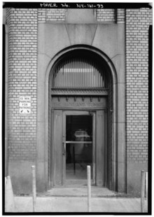
Does anyone know where the Holland Tunnel Headquarters and Maintenance Building whose entrance is depicted here is (or was)? In particular, was it in Manhattan or Jersey City? A street address would be particularly good. I don't think it is the current HQ. Photo is undated & probably a few decades old. - Jmabel | Talk 08:46, 5 December 2014 (UTC)
- I found another picture of it at Vintage NYC Photographs (scroll down about two thirds down the page), but frustratingly, it doesn't tell you where it is. Alansplodge (talk) 08:57, 5 December 2014 (UTC)
- Here is a view of the entire building, which might help. [Also on the page Alansplodge linked to.] ←Baseball Bugs What's up, Doc? carrots→ 09:01, 5 December 2014 (UTC)
- The Library of Congress says "HEADQUARTERS AND MAINTENANCE BUILDING, WEST SIDE - Holland Tunnel, Beneath Hudson River between New York & Jersey City, New York, New York County, NY". Does "West side" help? (I've never been to New York). The rest of the images are here. Alansplodge (talk) 09:03, 5 December 2014 (UTC)
- West side would be the New Jersey side. The full view of the building might help in placing it, but it doesn't jump out at me in Google Maps - which would make sense if it doesn't exist anymore. ←Baseball Bugs What's up, Doc? carrots→ 09:29, 5 December 2014 (UTC)
- It appears to be the building at 40°43′52″N 74°02′16″W / 40.7312°N 74.0377°W (Google street view) near the Jersey end of the tunnel. There's an architecturally similar Port Authority building near the Manhattan end; but it's larger (and has four stories rather than three), and it lacks the distinctive curved corner. Of course, the specific photo that Jmabel is inquiring about shows only the entrance; but the entrance of the Manhattan building, although it has "THE HOLLAND TUNNEL" surmounted by the row of ornaments (and "West Side" could refer to the West Side of Manhattan), is surrounded by different stonework. Deor (talk) 12:50, 5 December 2014 (UTC)
- Splendid! Yes, that looks like the one. It's on a dead-end street called Provost, just north of 13th, in the area north of where the ramps head to the tunnel. There's a Best Buy north of it across the expressway. ←Baseball Bugs What's up, Doc? carrots→ 16:50, 5 December 2014 (UTC)
- Thanks! If it's near 13th and Provost in Jersey City, it may indeed be the current HQ & Maintenance building (I've seen "13th and Provost" show up on some documents related to the tunnel). - Jmabel | Talk 18:06, 5 December 2014 (UTC)
- The current Jersey City maintenance complex for the Holland Tunnel appears to include all the buildings bounded by 13th, Provost, and I-78, including, but not limited to, the particular building appearing in the photo. Deor (talk) 18:30, 5 December 2014 (UTC)
- Thanks! If it's near 13th and Provost in Jersey City, it may indeed be the current HQ & Maintenance building (I've seen "13th and Provost" show up on some documents related to the tunnel). - Jmabel | Talk 18:06, 5 December 2014 (UTC)
- Splendid! Yes, that looks like the one. It's on a dead-end street called Provost, just north of 13th, in the area north of where the ramps head to the tunnel. There's a Best Buy north of it across the expressway. ←Baseball Bugs What's up, Doc? carrots→ 16:50, 5 December 2014 (UTC)
Heian period Japanese painting
edit

This is a picture of a copy of a Heian period Japanese painting, purchased at Salvation Army for 57 cents.
- What is this Japanese painting called?
- Where is the original? What museum?
- Who is the painter? When painted?
- What does it represent? Occasion?
- Who is in the palanquin?
- What does the oxcart represent?
- Tell me about the clothing
- What time or year was this?
- Apparently it is on Washi paper. --Doug Coldwell (talk) 15:50, 5 December 2014 (UTC)
The palanquin at the bottom left corner is a mikoshi, a portable Shinto shrine, so this is a festival procession. I'm afraid I can't be more help than that. Alansplodge (talk) 16:20, 5 December 2014 (UTC)
- I don't think it's a painting. White lines remind me of bingata prints. It might be a souvenir from Okinawa. Oxcarts, 牛車/gissha are vehicle used by nobles in the Heian era. See [5] and [6]. As for Heian costumes, you can see them at here. Click 次へ. It means "next page". Oda Mari (talk) 16:54, 5 December 2014 (UTC)
- (edit conflict) After some more Googling, apparently a ceremonial ox cart is called a goshoguruma, and is used in the Aoi Matsuri in Kyoto and the Dazaifu Tenjin Matsuri. Alansplodge (talk) 17:17, 5 December 2014 (UTC)
- All I could find from the net is that the original image is a scene from the Tale of Genji and that it comes from a folding screen (byoubu). No garantee of course any of this is correct so use carefully. I very much doubt this could be copied from a Heian period artifact. More probably an Edo period depiction of a scene from the Tale. I suppose you know you can search Google for that image. That search gives several matches to your image but I can't go through all of them. If you encounter Japanese language pages you can use Google Translate to give you a general idea of the contents and see if they don't say anything about the painting. Haven't got much more now. Maybe in the next few days. Also take a look at the Media Commons ("Tale of Genji" for example) to see if that image isn't there already. Contact Basemetal here 17:19, 5 December 2014 (UTC)
- Thank you for all the fine answers. It was most useful and will keep me busy for awhile.--Doug Coldwell (talk) 20:44, 10 December 2014 (UTC)