|
Featured picture tools: |
These featured pictures, as scheduled below, appeared as the picture of the day (POTD) on the English Wikipedia's Main Page in July 2021. Individual sections for each day on this page can be linked to with the day number as the anchor name (e.g. [[Wikipedia:Picture of the day/July 2021#1]] for July 1).
You can add an automatically updating POTD template to your user page using {{Pic of the day}} (version with blurb) or {{POTD}} (version without blurb). For instructions on how to make custom POTD layouts, see Wikipedia:Picture of the day.Purge server cache
July 1
|
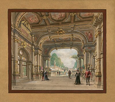
Les Huguenots is a French opera in five acts by Giacomo Meyerbeer, and is one of the most popular and spectacular examples of grand opera. With a libretto by Eugène Scribe and Émile Deschamps, the work premiered in Paris on 29 February 1836. This sketch in pen, watercolour and gouache by the scenic designer Philippe Chaperon depicts the set for the first act of Les Huguenots for an 1897 production of the opera at the Palais Garnier in Paris. Illustration credit: Philippe Chaperon; restored by Adam Cuerden
Recently featured:
|
July 2

|
|
St. Peter's Basilica is a church built in the Renaissance style located in Vatican City, the papal enclave in the city of Rome. Designed principally by Donato Bramante, Michelangelo, Carlo Maderno and Gian Lorenzo Bernini, and constructed between 1506 and 1626, the basilica is the most renowned work of Renaissance architecture, and the largest church in the world by its interior dimensions. This photograph shows the main facade and dome of St. Peter's Basilica as seen from St. Peter's Square. Photograph credit: Joaquim Alves Gaspar
Recently featured:
|
July 3
|
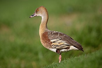
The plumed whistling duck (Dendrocygna eytoni) is a species of whistling duck native to Australia and New Guinea. Weighing around one kilogram (2.2 lb), it is a long-necked duck with brown upperparts, paler underparts and a white rump. The breast is chestnut-coloured with thin black bars, while long black-margined plumes arise from its flanks. The sexes are similar in appearance and its call is a characteristic whistle. This plumed whistling duck was photographed at Macquarie University, in New South Wales, Australia. Photograph credit: John Harrison
Recently featured:
|
July 4

|
|
Artists producing art and engraving on United States banknotes began experimenting with copper plates as an alternative to wood engraving in the early 18th century. Applied to the production of paper currency, copper-plate engraving, and later steel engraving, enabled banknote design and printing to rapidly advance during the 19th century. This vignette, engraved by Frederick Girsch of the American Bank Note Company, was first used on the reverse of the one-hundred-dollar denomination of the first series of federally-issued United States banknotes issued in 1863. Produced for the Department of the Treasury's Bureau of Engraving and Printing, the engraving is of John Trumbull's painting Declaration of Independence, depicting the Committee of Five presenting their draft of the United States Declaration of Independence to the Second Continental Congress. Engraving credit: Frederick Girsch, after John Trumbull; restored by Andrew Shiva
Recently featured:
|
July 5

|
|
Tofana di Rozes is a mountain in the Dolomites, located west of the resort of Cortina d'Ampezzo in northern Italy. At an elevation of 3,225 metres (10,581 ft), the mountain was first climbed by Paul Grohmann and local hunter Francesco Lacedelli in 1864. Most ascents of Tofana di Rozes are made from the north, where the mountain is a relatively easy hike, or from the west, where the summit can be reached by a via ferrata; this photograph shows the more challenging south face, which was first climbed in 1901. Photograph credit: Wolfgang Moroder |
July 6

|
Zonocerus variegatus, the variegated grasshopper, is a species of grasshopper in the family Pyrgomorphidae native to tropical western and central Africa. It feeds on a wide variety of plant foods and causes damage to crops, particularly cassava, groundnuts and vegetables, as well as transmitting diseases caused by mosaic viruses between plants. This Z. variegatus grasshopper was photographed in the Bobiri Forest in Ghana. Photograph credit: Charles James Sharp
Recently featured:
|
July 7

|
The Soyuz MS is the latest revision of the Russian spacecraft series Soyuz. It is an evolution of the Soyuz TMA-M, with modernization mostly concentrated on its communications and navigation subsystems. The spacecraft is used by Roscosmos for human spaceflight. The Soyuz MS has minimal external changes with respect to the Soyuz TMA-M, mostly limited to antennas and sensors, as well as the thruster placement. The first launch, Soyuz MS-01, took place on 7 July 2016 aboard a Soyuz-FG launch vehicle towards the International Space Station. This exploded-view diagram illustrates and labels various components of the Soyuz MS spacecraft and the Soyuz-FG rocket. Diagram credit: AstroBidules
Recently featured:
|
July 8

|
William Windom (1827–1891) was an American politician from Minnesota. He served as a Republican in the United States House of Representatives from 1859 to 1869, and in the United States Senate for three periods between 1870 and 1883. He also served twice as Secretary of the Treasury under three presidents. This line engraving of Windom was produced around 1902 by the Department of the Treasury's Bureau of Engraving and Printing (BEP) as part of a BEP presentation album of the first 42 secretaries of the treasury. Engraving credit: Bureau of Engraving and Printing; restored by Andrew Shiva
Recently featured:
|
July 9
|
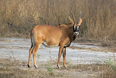
The roan antelope (Hippotragus equinus) is a species of savanna antelope found in western, central and southern Africa. Named for its reddish-brown coat, it has a black face with white patches around the eyes and the mouth, and a short erect mane of greyish brown hair extending from the back of the neck to the rump. This roan antelope, of the subspecies H. e. koba, was photographed in Senegal; the subspecies's range extends from Senegal to Benin in western Africa. Photograph credit: Charles James Sharp
Recently featured:
|
July 10

|
Elena Runggaldier (born 10 July 1990) is an Italian ski jumper and Nordic-combined skier. She won a silver medal at the FIS Nordic World Ski Championships 2011, and has taken part in four FIS Ski Jumping World Cups and represented Italy in ski jumping in two Winter Olympic Games. This photograph shows Runggaldier in Hinzenbach, Austria, where she competed in the 2014–15 FIS Ski Jumping World Cup. Photograph credit: Ailura; edited by Chris Woodrich
Recently featured:
|
July 11

|
Emily J. Harding (1850–1940) was a British artist, illustrator and suffragette, and a member of the Artists' Suffrage League. This poster, created by Harding around 1907 to 1918 in support of the suffrage movement in the United Kingdom, depicts a woman wearing an academic cap and gown standing inside a locked gate with a "convict" and a "lunatic", to illustrate the fact that none of the three had a vote for Parliament. Poster credit: Emily J. Harding; restored by Adam Cuerden
Recently featured:
|
July 12

|
The crested shriketit (Falcunculus frontatus) is a species of bird endemic to Australia, where it inhabits open eucalypt forest and woodland. It has a parrot-like beak that is used for stripping bark off trees in order to access insects and other invertebrates underneath. Males are larger than females in wing length, weight and bill-size, and have black throats, while females have olive-green throats; both sexes have bold black and white markings on the face. This male crested shriketit was photographed in Dharug National Park, New South Wales. Photograph credit: John Harrison
Recently featured:
|
July 13

|
R. J. Palacio (born July 13, 1963) is an American author and graphic designer. During her career, she has designed hundreds of book covers, including for both fiction and non-fiction works. She is also the author of several novels for children, including the best-selling Wonder, which has won several awards. Palacio is seen here signing a book at the 2019 BookCon convention in New York City. Photograph credit: Rhododendrites
Recently featured:
|
July 14
|
|
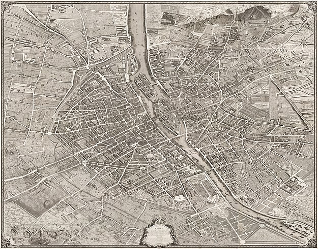
The Turgot map of Paris is a highly accurate and detailed map of the city of Paris, France, as it existed in the 1730s. It was published in 1739 as an atlas of twenty non-overlapping sectional bird's-eye-view maps, each approximately 50 cm × 80 cm (20 in × 31 in), in isometric perspective toward the southeast, as well as one simplified overview map with a four-by-five grid showing the layout of the twenty sectional maps. It has been described as "the first all-comprising graphical inventory of the capital, down to the last orchard and tree, detailing every house and naming even the most modest cul-de-sac". The complete map is shown here in its assembled form. Map credit: Louis Bretez and Claude Lucas
Recently featured:
|
Subpage 1
|
|
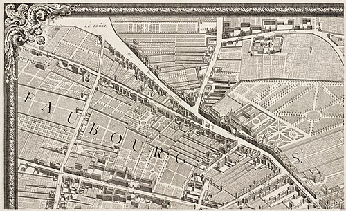
The Turgot map of Paris is a highly accurate and detailed map of the city of Paris, France, as it existed in the 1730s. It was published in 1739 as an atlas of twenty non-overlapping sectional bird's-eye-view maps, each approximately 50 cm × 80 cm (20 in × 31 in), in isometric perspective toward the southeast, as well as one simplified overview map with a four-by-five grid showing the layout of the twenty sectional maps. It has been described as "the first all-comprising graphical inventory of the capital, down to the last orchard and tree, detailing every house and naming even the most modest cul-de-sac". This is the first sheet of the Turgot map, covering part of the Faubourg Saint-Antoine, a suburb to the east of the city. Map credit: Louis Bretez and Claude Lucas
Recently featured:
|
Subpage 2

|
|
The Turgot map of Paris is a highly accurate and detailed map of the city of Paris, France, as it existed in the 1730s. It was published in 1739 as an atlas of twenty non-overlapping sectional bird's-eye-view maps, each approximately 50 cm × 80 cm (20 in × 31 in), in isometric perspective toward the southeast, as well as one simplified overview map with a four-by-five grid showing the layout of the twenty sectional maps. It has been described as "the first all-comprising graphical inventory of the capital, down to the last orchard and tree, detailing every house and naming even the most modest cul-de-sac". This is the second sheet of the Turgot map, covering part of the Faubourg Saint-Antoine, a suburb to the east of the city, and the Seine. Map credit: Louis Bretez and Claude Lucas
Recently featured:
|
Subpage 3

|
|
The Turgot map of Paris is a highly accurate and detailed map of the city of Paris, France, as it existed in the 1730s. It was published in 1739 as an atlas of twenty non-overlapping sectional bird's-eye-view maps, each approximately 50 cm × 80 cm (20 in × 31 in), in isometric perspective toward the southeast, as well as one simplified overview map with a four-by-five grid showing the layout of the twenty sectional maps. It has been described as "the first all-comprising graphical inventory of the capital, down to the last orchard and tree, detailing every house and naming even the most modest cul-de-sac". This is the third sheet of the Turgot map, covering part of the Faubourg Saint-Victor and the Faubourg Saint-Marcel, suburbs to the southeast of the city. The Pitié-Salpêtrière Hospital is visible at the top-left of this sheet. Map credit: Louis Bretez and Claude Lucas
Recently featured:
|
Subpage 4

|
|
The Turgot map of Paris is a highly accurate and detailed map of the city of Paris, France, as it existed in the 1730s. It was published in 1739 as an atlas of twenty non-overlapping sectional bird's-eye-view maps, each approximately 50 cm × 80 cm (20 in × 31 in), in isometric perspective toward the southeast, as well as one simplified overview map with a four-by-five grid showing the layout of the twenty sectional maps. It has been described as "the first all-comprising graphical inventory of the capital, down to the last orchard and tree, detailing every house and naming even the most modest cul-de-sac". This is the fourth sheet of the Turgot map, covering part of the Faubourg Saint-Marcel and Petit-Gentilly, suburbs to the south of the city. Map credit: Louis Bretez and Claude Lucas
Recently featured:
|
Subpage 5

|
|
The Turgot map of Paris is a highly accurate and detailed map of the city of Paris, France, as it existed in the 1730s. It was published in 1739 as an atlas of twenty non-overlapping sectional bird's-eye-view maps, each approximately 50 cm × 80 cm (20 in × 31 in), in isometric perspective toward the southeast, as well as one simplified overview map with a four-by-five grid showing the layout of the twenty sectional maps. It has been described as "the first all-comprising graphical inventory of the capital, down to the last orchard and tree, detailing every house and naming even the most modest cul-de-sac". This is the fifth sheet of the Turgot map, covering Popincourt, a suburb to the east of the city. Map credit: Louis Bretez and Claude Lucas
Recently featured:
|
Subpage 6

|
|
The Turgot map of Paris is a highly accurate and detailed map of the city of Paris, France, as it existed in the 1730s. It was published in 1739 as an atlas of twenty non-overlapping sectional bird's-eye-view maps, each approximately 50 cm × 80 cm (20 in × 31 in), in isometric perspective toward the southeast, as well as one simplified overview map with a four-by-five grid showing the layout of the twenty sectional maps. It has been described as "the first all-comprising graphical inventory of the capital, down to the last orchard and tree, detailing every house and naming even the most modest cul-de-sac". This is the sixth sheet of the Turgot map, covering the eastern part of the city centre, including the Bastille, and the Île Saint-Louis and Île Louviers in the Seine. Map credit: Louis Bretez and Claude Lucas
Recently featured:
|
Subpage 7

|
|
The Turgot map of Paris is a highly accurate and detailed map of the city of Paris, France, as it existed in the 1730s. It was published in 1739 as an atlas of twenty non-overlapping sectional bird's-eye-view maps, each approximately 50 cm × 80 cm (20 in × 31 in), in isometric perspective toward the southeast, as well as one simplified overview map with a four-by-five grid showing the layout of the twenty sectional maps. It has been described as "the first all-comprising graphical inventory of the capital, down to the last orchard and tree, detailing every house and naming even the most modest cul-de-sac". This is the seventh sheet of the Turgot map, covering the southeastern part of the city centre, including the Abbey of Saint-Victor at the top-left of the sheet and the Abbey of Sainte-Geneviève in the centre. Map credit: Louis Bretez and Claude Lucas
Recently featured:
|
Subpage 8

|
|
The Turgot map of Paris is a highly accurate and detailed map of the city of Paris, France, as it existed in the 1730s. It was published in 1739 as an atlas of twenty non-overlapping sectional bird's-eye-view maps, each approximately 50 cm × 80 cm (20 in × 31 in), in isometric perspective toward the southeast, as well as one simplified overview map with a four-by-five grid showing the layout of the twenty sectional maps. It has been described as "the first all-comprising graphical inventory of the capital, down to the last orchard and tree, detailing every house and naming even the most modest cul-de-sac". This is the eighth sheet of the Turgot map, covering part of the Faubourg Saint-Jacques and the Faubourg Saint-Michel, suburbs to the south of the city. Map credit: Louis Bretez and Claude Lucas
Recently featured:
|
Subpage 9

|
|
The Turgot map of Paris is a highly accurate and detailed map of the city of Paris, France, as it existed in the 1730s. It was published in 1739 as an atlas of twenty non-overlapping sectional bird's-eye-view maps, each approximately 50 cm × 80 cm (20 in × 31 in), in isometric perspective toward the southeast, as well as one simplified overview map with a four-by-five grid showing the layout of the twenty sectional maps. It has been described as "the first all-comprising graphical inventory of the capital, down to the last orchard and tree, detailing every house and naming even the most modest cul-de-sac". This is the ninth sheet of the Turgot map, covering part of the Courtille and the Faubourg du Temple, suburbs to the northeast of the city. Map credit: Louis Bretez and Claude Lucas
Recently featured:
|
Subpage 10

|
|
The Turgot map of Paris is a highly accurate and detailed map of the city of Paris, France, as it existed in the 1730s. It was published in 1739 as an atlas of twenty non-overlapping sectional bird's-eye-view maps, each approximately 50 cm × 80 cm (20 in × 31 in), in isometric perspective toward the southeast, as well as one simplified overview map with a four-by-five grid showing the layout of the twenty sectional maps. It has been described as "the first all-comprising graphical inventory of the capital, down to the last orchard and tree, detailing every house and naming even the most modest cul-de-sac". This is the tenth sheet of the Turgot map, covering the northern part of the city centre, including the Hôtel de Ville on the banks of the Seine at the top-right of the sheet and Saint-Martin-des-Champs Priory at the bottom-left. Map credit: Louis Bretez and Claude Lucas
Recently featured:
|
Subpage 11

|
|
The Turgot map of Paris is a highly accurate and detailed map of the city of Paris, France, as it existed in the 1730s. It was published in 1739 as an atlas of twenty non-overlapping sectional bird's-eye-view maps, each approximately 50 cm × 80 cm (20 in × 31 in), in isometric perspective toward the southeast, as well as one simplified overview map with a four-by-five grid showing the layout of the twenty sectional maps. It has been described as "the first all-comprising graphical inventory of the capital, down to the last orchard and tree, detailing every house and naming even the most modest cul-de-sac". This is the eleventh sheet of the Turgot map, covering the southern part of the city centre. The cathedral of Notre-Dame de Paris on the Île de la Cité is visible at the top-left of this sheet, the Pont Neuf spanning the Seine at the bottom left, and the abbey of Saint-Germain-des-Prés at the bottom-right. Map credit: Louis Bretez and Claude Lucas
Recently featured:
|
Subpage 12

|
|
The Turgot map of Paris is a highly accurate and detailed map of the city of Paris, France, as it existed in the 1730s. It was published in 1739 as an atlas of twenty non-overlapping sectional bird's-eye-view maps, each approximately 50 cm × 80 cm (20 in × 31 in), in isometric perspective toward the southeast, as well as one simplified overview map with a four-by-five grid showing the layout of the twenty sectional maps. It has been described as "the first all-comprising graphical inventory of the capital, down to the last orchard and tree, detailing every house and naming even the most modest cul-de-sac". This is the twelfth sheet of the Turgot map, covering part of the southwestern suburbs of the city. The Jardin du Luxembourg is visible at the top-left of this sheet. Map credit: Louis Bretez and Claude Lucas
Recently featured:
|
Subpage 13
|
|
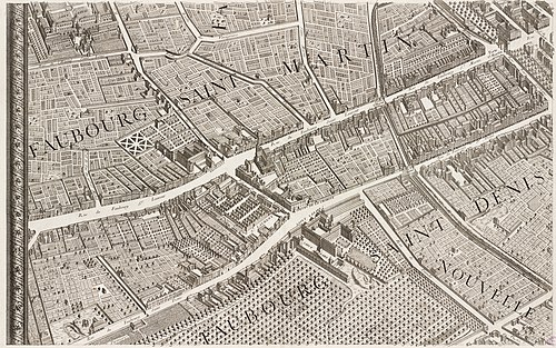
The Turgot map of Paris is a highly accurate and detailed map of the city of Paris, France, as it existed in the 1730s. It was published in 1739 as an atlas of twenty non-overlapping sectional bird's-eye-view maps, each approximately 50 cm × 80 cm (20 in × 31 in), in isometric perspective toward the southeast, as well as one simplified overview map with a four-by-five grid showing the layout of the twenty sectional maps. It has been described as "the first all-comprising graphical inventory of the capital, down to the last orchard and tree, detailing every house and naming even the most modest cul-de-sac". This is the thirteenth sheet of the Turgot map, covering part of the Faubourg Saint-Martin and the Faubourg Saint-Denis, suburbs to the north of the city. Saint-Lazare Prison is visible in the bottom-centre of the sheet. Map credit: Louis Bretez and Claude Lucas
Recently featured:
|
Subpage 14

|
|
The Turgot map of Paris is a highly accurate and detailed map of the city of Paris, France, as it existed in the 1730s. It was published in 1739 as an atlas of twenty non-overlapping sectional bird's-eye-view maps, each approximately 50 cm × 80 cm (20 in × 31 in), in isometric perspective toward the southeast, as well as one simplified overview map with a four-by-five grid showing the layout of the twenty sectional maps. It has been described as "the first all-comprising graphical inventory of the capital, down to the last orchard and tree, detailing every house and naming even the most modest cul-de-sac". This is the fourteenth sheet of the Turgot map, covering the northwestern part of the city centre. The Place des Victoires is visible at the centre-right of this sheet, and the church of Saint-Eustache at the top-right. Map credit: Louis Bretez and Claude Lucas
Recently featured:
|
Subpage 15

|
|
The Turgot map of Paris is a highly accurate and detailed map of the city of Paris, France, as it existed in the 1730s. It was published in 1739 as an atlas of twenty non-overlapping sectional bird's-eye-view maps, each approximately 50 cm × 80 cm (20 in × 31 in), in isometric perspective toward the southeast, as well as one simplified overview map with a four-by-five grid showing the layout of the twenty sectional maps. It has been described as "the first all-comprising graphical inventory of the capital, down to the last orchard and tree, detailing every house and naming even the most modest cul-de-sac". This is the fifteenth sheet of the Turgot map, covering the western part of the city centre, including the Louvre Palace and the Tuileries Garden on the banks of the Seine. Map credit: Louis Bretez and Claude Lucas
Recently featured:
|
Subpage 16

|
|
The Turgot map of Paris is a highly accurate and detailed map of the city of Paris, France, as it existed in the 1730s. It was published in 1739 as an atlas of twenty non-overlapping sectional bird's-eye-view maps, each approximately 50 cm × 80 cm (20 in × 31 in), in isometric perspective toward the southeast, as well as one simplified overview map with a four-by-five grid showing the layout of the twenty sectional maps. It has been described as "the first all-comprising graphical inventory of the capital, down to the last orchard and tree, detailing every house and naming even the most modest cul-de-sac". This is the sixteenth sheet of the Turgot map, covering the western suburbs of the city. The Hôtel des Invalides is visible at the bottom-right of this sheet. Map credit: Louis Bretez and Claude Lucas
Recently featured:
|
Subpage 17

|
|
The Turgot map of Paris is a highly accurate and detailed map of the city of Paris, France, as it existed in the 1730s. It was published in 1739 as an atlas of twenty non-overlapping sectional bird's-eye-view maps, each approximately 50 cm × 80 cm (20 in × 31 in), in isometric perspective toward the southeast, as well as one simplified overview map with a four-by-five grid showing the layout of the twenty sectional maps. It has been described as "the first all-comprising graphical inventory of the capital, down to the last orchard and tree, detailing every house and naming even the most modest cul-de-sac". This is the seventeenth sheet of the Turgot map, covering part of the Faubourg Montmartre, a suburb to the north of the city. Map credit: Louis Bretez and Claude Lucas
Recently featured:
|
Subpage 18

|
|
The Turgot map of Paris is a highly accurate and detailed map of the city of Paris, France, as it existed in the 1730s. It was published in 1739 as an atlas of twenty non-overlapping sectional bird's-eye-view maps, each approximately 50 cm × 80 cm (20 in × 31 in), in isometric perspective toward the southeast, as well as one simplified overview map with a four-by-five grid showing the layout of the twenty sectional maps. It has been described as "the first all-comprising graphical inventory of the capital, down to the last orchard and tree, detailing every house and naming even the most modest cul-de-sac". These are the eighteenth and nineteenth sheets of the Turgot map, covering part of the Porcherons and the Faubourg Saint-Honoré, suburbs to the northwest of the city, with a descriptive panel in the centre. Map credit: Louis Bretez and Claude Lucas
Recently featured:
|
Subpage 19

|
|
The Turgot map of Paris is a highly accurate and detailed map of the city of Paris, France, as it existed in the 1730s. It was published in 1739 as an atlas of twenty non-overlapping sectional bird's-eye-view maps, each approximately 50 cm × 80 cm (20 in × 31 in), in isometric perspective toward the southeast, as well as one simplified overview map with a four-by-five grid showing the layout of the twenty sectional maps. It has been described as "the first all-comprising graphical inventory of the capital, down to the last orchard and tree, detailing every house and naming even the most modest cul-de-sac". This is the twentieth sheet of the Turgot map, covering part of Gros Caillou, a suburb to the west of the city. The Île des Cygnes is visible in the Seine on the right-hand side of this sheet. Map credit: Louis Bretez and Claude Lucas
Recently featured:
|
July 15

|
Calumma crypticum, the blue-legged chameleon, is a species of chameleon found in eastern Madagascar. As with other chameleons, an individual's colour is variable and depends on its surroundings, the ambient temperature, and variations in the level of light. The species is usually quite colourful, with rich browns, blues and greens; the legs are often marked with blue. This C. crypticum individual was photographed in Ranomafana National Park, Madagascar, and can be identified as a male by its long snout with a horn-like protrusion. Photograph credit: Charles James Sharp
Recently featured:
|
July 16
|
|
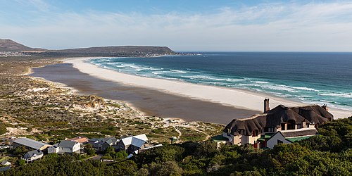
Noordhoek is a coastal town in the Western Cape, South Africa, located below Chapman's Peak on the west coast of the Cape Peninsula and is approximately 35 km (22 mi) to the south of Cape Town. The beach is a six-kilometre (3.7 mi) stretch of fine white sand used by walkers and horse-riders; winds are often strong and the sea is cold and wild. The neighbouring suburb of Kommetjie can be seen in the distance. Photograph credit: Diego Delso
Recently featured:
|
July 17

|
At the Seashore is an 1886 oil-on-canvas painting by the Polish artist Anna Bilińska-Bohdanowicz, depicting a young woman from a fishing village sitting on the sand with her little daughter. The painting presents a realistic scene from a beach located by the English Channel and conveys a profound sense of melancholy. Painted in Pourville, Normandy, the work is a reflection on the recent death of the artist's father, and a close friend. The painting is part of the collection of the National Museum in Warsaw, Poland. Painting credit: Anna Bilińska-Bohdanowicz
Recently featured:
|
July 18

|
The bar-tailed godwit (Limosa lapponica) is a large wading bird in the family Scolopacidae. Breeding takes place each summer in the Arctic, and the bird then makes a long-distance migration southwards to overwinter in more temperate areas, mostly in the Southern Hemisphere. This photograph, taken in March, shows a bird in non-breeding plumage at Taren Point in New South Wales, Australia. Photograph credit: John Harrison
Recently featured:
|
July 19

|
Robert J. Walker (July 19, 1801 – November 11, 1869) was an American lawyer, economist and politician. He served as a member of the United States Senate representing the state of Mississippi from 1835 until 1845, and as Secretary of the Treasury from 1845 to 1849 during the administration of President James K. Polk. This line engraving of Walker was produced by the Department of the Treasury's Bureau of Engraving and Printing (BEP) as part of a BEP presentation album of treasury secretaries. The portrait appeared on the fifth issue of 25-cent fractional-currency notes, issued in 1874. Engraving credit: Bureau of Engraving and Printing; restored by Andrew Shiva
Recently featured:
|
July 20

|
Tranquility Base is the landing site of the Apollo 11 mission on the Moon where, on July 20, 1969, humans first landed and walked on a celestial body other than the Earth. This photograph was taken at Tranquility Base by Neil Armstrong, the Apollo 11 commander, and depicts crewmember Buzz Aldrin with scientific equipment he had just deployed on the lunar surface. In the background on the right of the image is the lunar module, Eagle; the United States flag planted at the site during the mission was blown over the next day by the exhaust of the ascent rocket. Photograph credit: Neil Armstrong
Recently featured:
|
July 21

|
The Alcázar of Seville is a royal palace in Seville, Spain, built for the Christian king Peter of Castile in 1364–1366. It was built by Castilian Christians on the site of an Abbadid Muslim alcázar, or residential fortress, destroyed after the Christian reconquest of Seville. The palace is a prime example of Mudéjar architecture in the Iberian Peninsula, but also features elements of Gothic, Renaissance and Romanesque architecture from previous stages of construction. This photograph depicts the domed ceiling of the Hall of Ambassadors in the Alcázar of Seville. Photograph credit: Joaquim Alves Gaspar
Recently featured:
|
July 22
|
|
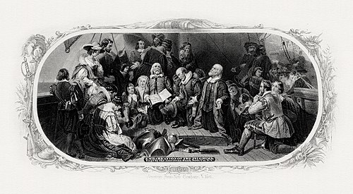
Artists producing art and engraving on United States banknotes began experimenting with copper plates as an alternative to wood engraving in the early 18th century. Applied to the production of paper currency, copper-plate engraving, and later steel engraving, enabled banknote design and printing to rapidly advance during the 19th century. This vignette, engraved by W. W. Rice, appeared on certain United States fifty-dollar bills issued in 1875. Produced for the Department of the Treasury's Bureau of Engraving and Printing, the engraving is of Robert Walter Weir's painting Embarkation of the Pilgrims, which hangs in the United States Capitol rotunda. It depicts the Pilgrims on the deck of the ship Speedwell as they depart Delfshaven in South Holland on July 22, 1620. They met additional colonists at Southampton, England, and transferred to the Mayflower before sailing to the New World. Engraving credit: W. W. Rice, after Robert Walter Weir; restored by Andrew Shiva
Recently featured:
|
July 23
|
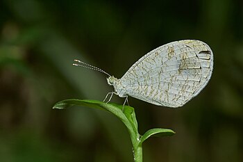
Leptosia nina, known as the psyche, is a species of butterfly in the family Pieridae (the sulphurs, yellows and whites), found in the Indian subcontinent, southeastern Asia, and Australia. It has a small wingspan of 2.5 to 5 cm (1 to 2 in). The upper side of the otherwise white forewing has a large, somewhat pear-shaped, black spot; this spot is also present on the underside which is scattered with greenish dots and speckles, sometimes arranged in bands. This L. nina butterfly was photographed in Kerala, India. Photograph credit: Jeevan Jose
Recently featured:
|
July 24

|
John Adams Dix (July 24, 1798 – April 21, 1879) was Secretary of the Treasury, Governor of New York and a major general in the Union Army during the American Civil War. He was notable for arresting the pro-Southern Maryland General Assembly, preventing that divided border state from seceding, and for arranging a system for prisoner exchange via the Dix–Hill Cartel, concluded in partnership with Confederate Major General Daniel Harvey Hill. This line engraving of Dix was produced around 1902 by the Department of the Treasury's Bureau of Engraving and Printing (BEP) as part of a BEP presentation album of the first 42 secretaries of the treasury. Engraving credit: Bureau of Engraving and Printing; restored by Andrew Shiva
Recently featured:
|
July 25

|
|
The Castle of St John the Baptist, also called the Black Castle, is a circular fort in Santa Cruz de Tenerife in the Canary Islands. It is located in the heart of the city, near the Parque Marítimo César Manrique and behind the Auditorio de Tenerife. Construction began in 1641 and was completed in 1644. The structure was later rebuilt in 1765 with the addition of a cylindrical tower facing the sea. It served as a military fort until 1924 and was converted to a military museum in 1948. A re-enactment of the Battle of Santa Cruz de Tenerife takes place annually at the castle, commemorating the unsuccessful attempt by the British admiral Horatio Nelson to invade the city and archipelago on 25 July 1797. Photograph credit: Thomas Wolf
Recently featured:
|
July 26
Subpage 1
|
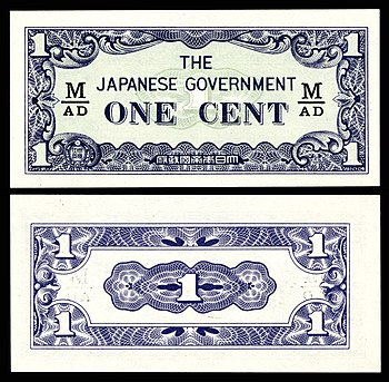
The Japanese government-issued dollar was a form of currency issued between 1942 and 1945 for use within the territories of Singapore, Malaya, North Borneo, Sarawak and Brunei, under occupation by Imperial Japan during World War II. The currency, informally referred to as "banana money", was released solely in the form of banknotes, as metals were considered essential to the war effort. The languages used on the notes were reduced to English and Japanese. Each note bears a different obverse and reverse design, but all have a similar layout, and were marked with stamped block letters that begin with "M" for "Malaya". This 1942 one-cent Japanese-issued banknote is part of the National Numismatic Collection at the Smithsonian Institution. Banknote design credit: Empire of Japan; photographed by Andrew Shiva
Recently featured:
|
Subpage 2
|
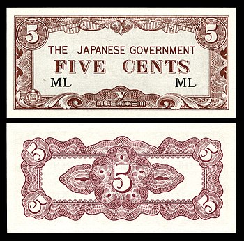
The Japanese government-issued dollar was a form of currency issued between 1942 and 1945 for use within the territories of Singapore, Malaya, North Borneo, Sarawak and Brunei, under occupation by Imperial Japan during World War II. The currency, informally referred to as "banana money", was released solely in the form of banknotes, as metals were considered essential to the war effort. The languages used on the notes were reduced to English and Japanese. Each note bears a different obverse and reverse design, but all have a similar layout, and were marked with stamped block letters that begin with "M" for "Malaya". This 1942 five-cent Japanese-issued banknote is part of the National Numismatic Collection at the Smithsonian Institution. Banknote design credit: Empire of Japan; photographed by Andrew Shiva
Recently featured:
|
Subpage 3
|
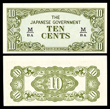
The Japanese government-issued dollar was a form of currency issued between 1942 and 1945 for use within the territories of Singapore, Malaya, North Borneo, Sarawak and Brunei, under occupation by Imperial Japan during World War II. The currency, informally referred to as "banana money", was released solely in the form of banknotes, as metals were considered essential to the war effort. The languages used on the notes were reduced to English and Japanese. Each note bears a different obverse and reverse design, but all have a similar layout, and were marked with stamped block letters that begin with "M" for "Malaya". This 1942 ten-cent Japanese-issued banknote is part of the National Numismatic Collection at the Smithsonian Institution. Banknote design credit: Empire of Japan; photographed by Andrew Shiva
Recently featured:
|
Subpage 4

|
The Japanese government-issued dollar was a form of currency issued between 1942 and 1945 for use within the territories of Singapore, Malaya, North Borneo, Sarawak and Brunei, under occupation by Imperial Japan during World War II. The currency, informally referred to as "banana money", was released solely in the form of banknotes, as metals were considered essential to the war effort. The languages used on the notes were reduced to English and Japanese. Each note bears a different obverse and reverse design, but all have a similar layout, and were marked with stamped block letters that begin with "M" for "Malaya". This 1942 fifty-cent Japanese-issued banknote, depicting a traveller's palm on the obverse, is part of the National Numismatic Collection at the Smithsonian Institution. Banknote design credit: Empire of Japan; photographed by Andrew Shiva
Recently featured:
|
Subpage 5
|
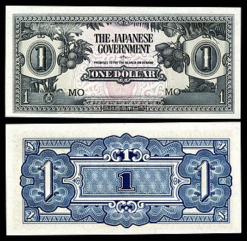
The Japanese government-issued dollar was a form of currency issued between 1942 and 1945 for use within the territories of Singapore, Malaya, North Borneo, Sarawak and Brunei, under occupation by Imperial Japan during World War II. The currency, informally referred to as "banana money", was released solely in the form of banknotes, as metals were considered essential to the war effort. The languages used on the notes were reduced to English and Japanese. Each note bears a different obverse and reverse design, but all have a similar layout, and were marked with stamped block letters that begin with "M" for "Malaya". This 1942 one-dollar Japanese-issued banknote, depicting breadfruit and coconut trees on the obverse, is part of the National Numismatic Collection at the Smithsonian Institution. Banknote design credit: Empire of Japan; photographed by Andrew Shiva
Recently featured:
|
Subpage 6
|
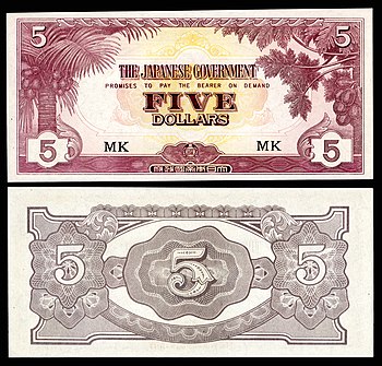
The Japanese government-issued dollar was a form of currency issued between 1942 and 1945 for use within the territories of Singapore, Malaya, North Borneo, Sarawak and Brunei, under occupation by Imperial Japan during World War II. The currency, informally referred to as "banana money", was released solely in the form of banknotes, as metals were considered essential to the war effort. The languages used on the notes were reduced to English and Japanese. Each note bears a different obverse and reverse design, but all have a similar layout, and were marked with stamped block letters that begin with "M" for "Malaya". This 1942 five-dollar Japanese-issued banknote, depicting coconut and pawpaw trees on the obverse, is part of the National Numismatic Collection at the Smithsonian Institution. Banknote design credit: Empire of Japan; photographed by Andrew Shiva
Recently featured:
|
Subpage 7
|
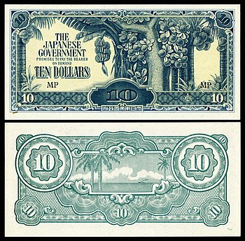
The Japanese government-issued dollar was a form of currency issued between 1942 and 1945 for use within the territories of Singapore, Malaya, North Borneo, Sarawak and Brunei, under occupation by Imperial Japan during World War II. The currency, informally referred to as "banana money", was released solely in the form of banknotes, as metals were considered essential to the war effort. The languages used on the notes were reduced to English and Japanese. Each note bears a different obverse and reverse design, but all have a similar layout, and were marked with stamped block letters that begin with "M" for "Malaya". This 1944 ten-dollar Japanese-issued banknote, depicting guava and coconut trees flanked by banana and pineapple plants on the obverse, and a seascape on the reverse, is part of the National Numismatic Collection at the Smithsonian Institution. Banknote design credit: Empire of Japan; photographed by Andrew Shiva
Recently featured:
|
Subpage 8
|
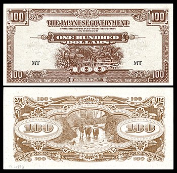
The Japanese government-issued dollar was a form of currency issued between 1942 and 1945 for use within the territories of Singapore, Malaya, North Borneo, Sarawak and Brunei, under occupation by Imperial Japan during World War II. The currency, informally referred to as "banana money", was released solely in the form of banknotes, as metals were considered essential to the war effort. The languages used on the notes were reduced to English and Japanese. Each note bears a different obverse and reverse design, but all have a similar layout, and were marked with stamped block letters that begin with "M" for "Malaya". This 1944 one-hundred-dollar Japanese-issued banknote, depicting a Malay house with palm trees on the obverse, and a man with water buffaloes in a stream on the reverse, is part of the National Numismatic Collection at the Smithsonian Institution. Banknote design credit: Empire of Japan; photographed by Andrew Shiva
Recently featured:
|
Subpage 9
|
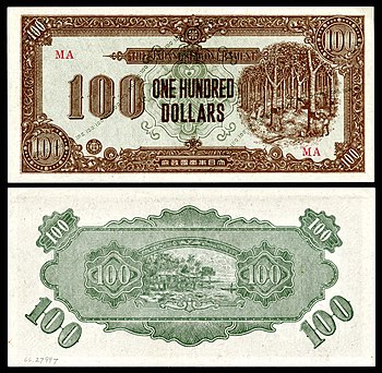
The Japanese government-issued dollar was a form of currency issued between 1942 and 1945 for use within the territories of Singapore, Malaya, North Borneo, Sarawak and Brunei, under occupation by Imperial Japan during World War II. The currency, informally referred to as "banana money", was released solely in the form of banknotes, as metals were considered essential to the war effort. The languages used on the notes were reduced to English and Japanese. Each note bears a different obverse and reverse design, but all have a similar layout, and were marked with stamped block letters that begin with "M" for "Malaya". This 1945 one-hundred-dollar Japanese-issued banknote, depicting labourers in a rubber plantation on the obverse, and stilted Malay houses on the reverse, is part of the National Numismatic Collection at the Smithsonian Institution. Banknote design credit: Empire of Japan; photographed by Andrew Shiva
Recently featured:
|
Subpage 10
|
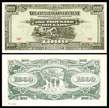
The Japanese government-issued dollar was a form of currency issued between 1942 and 1945 for use within the territories of Singapore, Malaya, North Borneo, Sarawak and Brunei, under occupation by Imperial Japan during World War II. The currency, informally referred to as "banana money", was released solely in the form of banknotes, as metals were considered essential to the war effort. The languages used on the notes were reduced to English and Japanese. Each note bears a different obverse and reverse design, but all have a similar layout, and were marked with stamped block letters that begin with "M" for "Malaya". This 1945 one-thousand-dollar Japanese-issued banknote, depicting a bullock cart on the obverse and a man with water buffaloes in a stream on the reverse, is part of the National Numismatic Collection at the Smithsonian Institution. Banknote design credit: Empire of Japan; photographed by Andrew Shiva
Recently featured:
|
July 27
|
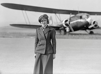
The 1934 Swissair Tuttlingen accident occurred on 27 July 1934 when a Curtiss T-32 Condor II aircraft operated by Swissair crashed near Tuttlingen, Germany, while flying through a thunderstorm, killing all twelve people on board. This 1934 photograph shows Nelly Diener, the first air stewardess in Europe, standing in front of the aircraft in which she would lose her life that same year. Photograph credit: Swissair; retouched by PawełMM and Brandmeister |
July 28

|
Carmen is an opera in four acts by the French composer Georges Bizet, with a libretto written by Henri Meilhac and Ludovic Halévy based on a novella by Prosper Mérimée. This lithographic poster, illustrated by Prudent-Louis Leray, advertised the opera's premiere, which took place in Paris on 3 March 1875. It was not initially a success; the audience at the Opéra-Comique was shocked by the drastic realism of the action and by the low standing and immorality of most of the characters. However, later that year, after Bizet's unexpected death, an adaptation by Ernest Guiraud performed by the Vienna Court Opera became a great success with the public, and Guiraud's version went on to achieve worldwide fame. Poster credit: Prudent-Louis Leray; restored by Adam Cuerden |
July 29

|
The Palestine sunbird (Cinnyris osea) is a small passerine bird of the sunbird family, Nectariniidae, found in parts of the Middle East and sub-Saharan Africa. Its long, downward-curving beak and the brush-tipped tongue are adapted for sipping nectar from flowers. The Palestinian Authority adopted the species as a national bird in 2015. This male Palestine sunbird in breeding plumage was photographed in the Dana Biosphere Reserve in Jordan. Photograph credit: Charles James Sharp |
July 30

|
Nebotičnik is a high-rise building located in the centre of Ljubljana, Slovenia. On completion in 1933, it was the tallest building in the Kingdom of Yugoslavia, and the ninth-tallest in Europe. There are shops on the ground and first floors, and offices on floors two to five. The sixth to ninth floors are private residences, and a café, bar and observation deck are located on the top three floors. The entrance on the ground floor leads to a lobby from which the upper storeys are accessible by elevator or by this Art Deco spiral stairway at the centre of the building. Photograph credit: Petar Milošević
Recently featured:
|
July 31
|
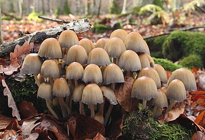
Coprinellus micaceus is a common species of fungus in the family Psathyrellaceae with a cosmopolitan distribution. It is a saprotrophic species, deriving nutrients from dead and decomposing wood. The fruiting body grows in clusters and is commonly known as the mica cap or shiny cap because of the fine layer of reflective mica-like cells on the cap surface. The fungus is edible soon after collection, but after a few hours, the gills begin to slowly dissolve into a black, inky, spore-laden liquid. These C. micaceus mushrooms were photographed near Erbach an der Donau, Germany. Photograph credit: Holger Krisp
Recently featured:
|
Picture of the day archives and future dates