You can help expand this article with text translated from the corresponding article in French. (December 2008) Click [show] for important translation instructions.
|
Villeret (French pronunciation: [vilʁɛ]) is a commune in the Aisne department in Hauts-de-France in northern France.
Villeret | |
|---|---|
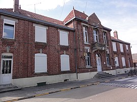
 The town hall of Villeret | |
| Coordinates: 49°57′11″N 3°11′38″E / 49.9531°N 3.1939°E | |
| Country | France |
| Region | Hauts-de-France |
| Department | Aisne |
| Arrondissement | Saint-Quentin |
| Canton | Bohain-en-Vermandois |
| Intercommunality | Pays du Vermandois |
| Government | |
| • Mayor (2020–2026) | Michel Marie[1] |
Area 1 | 3.95 km2 (1.53 sq mi) |
| Population (2022)[2] | 268 |
| • Density | 68/km2 (180/sq mi) |
| Time zone | UTC+01:00 (CET) |
| • Summer (DST) | UTC+02:00 (CEST) |
| INSEE/Postal code | 02808 /02420 |
| Elevation | 97–147 m (318–482 ft) (avg. 138 m or 453 ft) |
| 1 French Land Register data, which excludes lakes, ponds, glaciers > 1 km2 (0.386 sq mi or 247 acres) and river estuaries. | |
Population
edit| Year | Pop. | ±% |
|---|---|---|
| 1962 | 413 | — |
| 1968 | 390 | −5.6% |
| 1975 | 323 | −17.2% |
| 1982 | 291 | −9.9% |
| 1990 | 293 | +0.7% |
| 1999 | 311 | +6.1% |
| 2008 | 314 | +1.0% |
| 2012 | 312 | −0.6% |
History
editDuring the first World War, Villeret was under German occupation. Citizens of Villeret secretly sheltered a group of British soldiers who had become detached from their units in September 1914. Four of the men were discovered by the Germans and executed in 1916. This story was the subject of the 2011 book "The Englishman's Daughter / A True Story of Love and Betrayal in World War I" by Ben Macintyre. The early chapters of the book contain information on the history of Villeret.
See also
editReferences
edit- ^ "Répertoire national des élus: les maires". data.gouv.fr, Plateforme ouverte des données publiques françaises (in French). 2 December 2020.
- ^ "Populations de référence 2022" (in French). The National Institute of Statistics and Economic Studies. 19 December 2024.
External links
editWikimedia Commons has media related to Villeret (Aisne).


