Vandoncourt (French pronunciation: [vɑ̃dɔ̃kuʁ]) is a commune in the Doubs department in the Bourgogne-Franche-Comté region in eastern France.
Vandoncourt | |
|---|---|
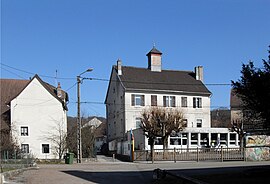
 Town hall and school | |
| Coordinates: 47°28′04″N 6°54′07″E / 47.4678°N 6.9019°E | |
| Country | France |
| Region | Bourgogne-Franche-Comté |
| Department | Doubs |
| Arrondissement | Montbéliard |
| Canton | Audincourt |
| Intercommunality | Pays de Montbéliard Agglomération |
| Government | |
| • Mayor (2023–2026) | Dominique Bouveresse[1] |
Area 1 | 8.57 km2 (3.31 sq mi) |
| Population (2021)[2] | 814 |
| • Density | 95/km2 (250/sq mi) |
| Time zone | UTC+01:00 (CET) |
| • Summer (DST) | UTC+02:00 (CEST) |
| INSEE/Postal code | 25586 /25230 |
| Elevation | 370–611 m (1,214–2,005 ft) |
| 1 French Land Register data, which excludes lakes, ponds, glaciers > 1 km2 (0.386 sq mi or 247 acres) and river estuaries. | |
Geography
editVandoncourt lies 4.5 km (2.8 mi) southeast of Hérimoncourt and 7 km (4.3 mi) from the Swiss border. It occupies a transitional position between the Vosges Mountains and Alsace to the north and the Jura mountains on the south, Switzerland on the east and the plain of the river Saône on the west.
It is perched on a high plateau, which dominates the region.
Population
edit| Year | Pop. | ±% p.a. |
|---|---|---|
| 1968 | 557 | — |
| 1975 | 605 | +1.19% |
| 1982 | 594 | −0.26% |
| 1990 | 605 | +0.23% |
| 1999 | 626 | +0.38% |
| 2009 | 821 | +2.75% |
| 2014 | 849 | +0.67% |
| 2020 | 809 | −0.80% |
| Source: INSEE[3] | ||
See also
editReferences
edit- ^ "Répertoire national des élus: les maires" (in French). data.gouv.fr, Plateforme ouverte des données publiques françaises. 30 November 2023.
- ^ "Populations légales 2021" (in French). The National Institute of Statistics and Economic Studies. 28 December 2023.
- ^ Population en historique depuis 1968, INSEE
External links
editWikimedia Commons has media related to Vandoncourt.
- Vandoncourt on the regional Web site (in French)


