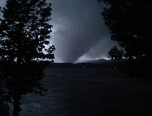
 The large and violent tornado crossing through the Coosa River | |
| Meteorological history | |
|---|---|
| Formed | April 27, 2011, 6:28 p.m. CDT (UTC−05:00) |
| Dissipated | April 27, 2011, 9:15 p.m. EDT (UTC–05:00) |
| Duration | 1 hour, 47 minutes |
| EF4 tornado | |
| on the Enhanced Fujita scale | |
| Highest winds | 180 mph (290 km/h) |
| Overall effects | |
| Fatalities | 22 |
| Injuries | 85 |
| Damage | $366,755,000 (2011 USD) |
| Areas affected | Margaret, Ohatchee, Piedmont, Alabama |
Part of the 2011 Super Outbreak and Tornadoes of 2011 | |
During the evening hours of April 27, 2011, amid the 2011 Super Outbreak, a large and violent tornado devastated the community of Shoal Creek and the northern portion of Ohatchee, Alabama. The National Weather Service forecasting office in Birmingham, Alabama rated the worst of the damage EF4 on the Enhanced Fujita scale with winds estimated at 180 miles per hour (290 km/h).
Meteorological synopsis
editOn April 23, the Storm Prediction Center (SPC) began monitoring the potential for a substantial severe weather outbreak in the extended range.[1] As a shortwave trough tracked across portions of the Mid-South and southeastern United States, moderate instability and strong wind shear ahead of a trailing cold front was expected to promote the development of supercell thunderstorms capable of producing tornadoes, large hail, and damaging winds.[2] Two days before the event, on April 25, the SPC issued a moderate risk of severe weather encompassing portions of central and eastern Kentucky, middle and eastern Tennessee, northeast Mississippi, central and northern Alabama, and northwest Georgia. Due to the combination of rich low-level moisture, strong shear, and focused large-scale ascent, there was relatively high confidence across the outlined area for strong tornadoes – a tornado rated EF2 or higher on the Enhanced Fujita scale – and widespread damaging winds.[3] By the morning of April 27, the SPC upgraded to a high risk of severe weather,[4] noting that a dangerous tornado outbreak capable of producing several violent – EF4 tornado or stronger on the Enhanced Fujita scale – and long-track tornadoes was expected.[5][6]
Shortly before noon, the probability of tornadoes within 25 miles of a location was increased even further to 45%, a level exceeding even typical high-risk standards, for an area including Tuscaloosa. The forecast continued to emphasize the risk of strong/violent and very damaging tornadoes, as confidence increased even further regarding the risk of an extreme, high-end tornado outbreak. Throughout the afternoon hours, in the wake of two earlier mesoscale convective systems, the air mass across western and northern portions of Alabama began to quickly destabilize, with mixed layer convective available potential energy (CAPE) estimated in the 2500–4000 j/kg range and low-level dew points of 70–72 °F (21–22 °C) surging northward from Louisiana. Meanwhile, the wind shear environment became substantially more favorable as an 80–100 kn mid-level jet ejected eastward into the region.[5] At 1:45 p.m. CDT (18:45 UTC), a Particularly Dangerous Situation (PDS) tornado watch was issued for much of Alabama, northwest Georgia, southeast Mississippi, and southern middle Tennessee, with a >95% probability of at least two tornadoes and one or more strong tornadoes.[7]
After the Tuscaloosa–Birmingham tornado dissipated northwest of Birmingham at 6:14 p.m. CDT, the supercell responsible for the tornado quickly recycled. The National Weather Service's Birmingham office issued a tornado warning at 6:18 p.m., citing the parent storm's danger and capability to produce another tornado.[8]
Tornado summary
editThe tornado formed northeast of Trussville at 6:28 p.m.[9][10] In its initial EF0 phase, the tornado uprooted and snapped multiple hardwood and softwood trees.[11][12] The tornado crossed into western St. Clair County and intensified slightly as it passed immediately north of Odenville, producing EF1-level damage.[9]
See also
editReferences
edit- ^ Steve Goss (April 23, 2011). "Day 4-8 Severe Weather Outlook Issued on Apr 23, 2011". Storm Prediction Center. National Oceanic and Atmospheric Administration. Retrieved December 7, 2013.
- ^ Steve Goss (April 24, 2011). "Day 4-8 Severe Weather Outlook Issued on Apr 24, 2011". Storm Prediction Center. National Oceanic and Atmospheric Administration. Retrieved December 7, 2013.
- ^ Steve Goss (April 25, 2011). "Apr 25, 2011 0730 UTC Day 3 Severe Thunderstorm Outlook". Storm Prediction Center. National Oceanic and Atmospheric Administration. Retrieved December 7, 2013.
- ^ Ryan Jewell (April 27, 2011). "Apr 27, 2011 1200 UTC Day 1 Convective Outlook". Storm Prediction Center. National Oceanic and Atmospheric Administration. Retrieved December 7, 2013.
- ^ a b Ariel Cohen; Richard Thompson (April 27, 2011). "Apr 27, 2011 1300 UTC Day 1 Convective Outlook". Storm Prediction Center. National Oceanic and Atmospheric Administration. Retrieved December 7, 2013.
- ^ Ariel Cohen (April 27, 2011). "Public Severe Weather Outlook". Storm Prediction Center. National Oceanic and Atmospheric Administration. Retrieved December 7, 2013.
- ^ John Hart (April 27, 2011). "Particularly Dangerous Situation (PDS) Tornado Watch 235". Storm Prediction Center. National Oceanic and Atmospheric Administration. Retrieved December 7, 2013.
- ^ "IEM :: Valid Time Event Code (VTEC) App". mesonet.agron.iastate.edu. Retrieved 2024-08-11.
- ^ a b "Storm Events Database - Event Details | National Centers for Environmental Information". www.ncdc.noaa.gov. Retrieved 2024-07-29.
- ^ "Argo-Shoal Creek-Ohatchee-Forney Tornado - April 27, 2011". 2015-04-13. Archived from the original on 2015-04-13. Retrieved 2024-07-29.
- ^ "ArcGIS Web Application". apps.dat.noaa.gov. Retrieved 2024-07-29.
- ^ "EF1 Jefferson County: Storm Events Database - Event Details | National Centers for Environmental Information". www.ncdc.noaa.gov. Retrieved 2024-07-29.
Category:2011 natural disasters in the United States Category:2011 in Alabama Category:F4 tornadoes Category:Tornadoes of 2011 Category:Tornadoes in Alabama Category:April 2011 events in the United States