Hello! I track tropical and subtropical cyclones around the world.
| This user participates in WikiProject Tropical cyclones. |
| This user participates in the Non-tropical storms task force. |
| This user likes tracking tropical cyclones. |
| This user is really fascinated by the weather. |
| This user is interested in severe weather. |
| This user is a participant in WikiProject Weather |
| This user's most intense tropical cyclone ever experienced was Hurricane Marie in 2014. |
Interesting weather and space images
edit-
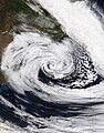
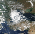 A possible subtropical cyclone in the Black Sea on September 27, 2005.
 -
 Radar scan of the 2021 Western Kentucky tornado lifting debris from the town of Mayfield 30,000 feet into the atmosphere.
 -
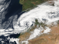
 Storm Dennis, the most intense European windstorm of the 21st century, on February 15, 2020.
 -

-
 Track of Tropical Storm Five of the 1952 Atlantic hurricane season, the northernmost forming Atlantic tropical cyclone.
 -
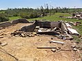 A house that was wiped off its foundation after the extremely violent 2011 Hackleburg–Phil Campbell tornado.
 -

-
 Subtropical Cyclone Katie near Easter Island on May 2, 2015.
 -
 One of the first photos of the Andromeda Galaxy, taken in 1899 by Issac Roberts.
 -
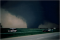 Image of the 1997 Jarrell tornado at peak intensity over the Double Creek Estates in Jarrell, Texas.
 -
 Satellite image of the 2022 Hunga Tonga–Hunga Haʻapai eruption and the extratropical remnants of Cyclone Cody.
 -
 Radar loop of the most prolific December tornado outbreak on record on December 15, 2021.
 -
 Cryovolcanoes spewing out ice at the south pole of Enceladus.
 -
 Hurricane Dorian approaching Canada as powerful extratropical cyclone on September 7, 2019.
 -
 An unrated landspout tornado near Marble, Colorado on May 29, 2021.
 -
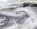
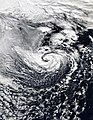
 A record-breaking bomb cyclone off the coast of the Pacific Northwest on October 24, 2021.
 -
 Subtropical Storm One at peak intensity on January 16, 2023.
 -
 C/2022 E3 (ZTF), a long-period comet, on January 27, 2023.
 -
 A waterspout inside of Tropical Storm Colin on June 6, 2016.
 -
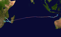 Track of Cyclone Freddy, the longest-lived tropical cyclone on record.
 -
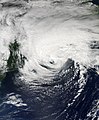
 A potential subtropical storm of the coast of Morroco on February 17, 2002.
 -
 The 1904, Moscow tornado, one of the deadliest Russian tornadoes on record.
 -
 2023 CX1 entering Earth's atmosphere over France on February 13, 2023.
 -
 Subtropical Storm Raoni off the coast of Argentina on June 28, 2021


.jpg)


-_Alessandro_Bianconi.jpg)


Tropical cyclones in 2023 (personal analysis)
edit
Subpages
editMy Subpages:
Good ones/Actively working on
edit- My sandbox
- Effects of the 1982–83 El Niño in Peru†
- Tropical Storm Namtheun (2021)†
- Unusual areas of tropical cyclogensis†
- Potential Tropical Cyclone Four†
- F6
- 2023 Naypyidaw tornado†
- List of costliest tropical cyclones
Inactive
edit- Significant tornadoes of 2023
- Table of Central Pacific tropical cyclones†
- Deadliest tropical cyclones by basin
Mainspace
edit- List of costliest tropical cyclones
- Template:Table of F5 and EF5 tornadoes
- Weather of 1985
- October 2022 Southern Ocean cyclone
† open to editing from others
My best works
edit- Weather of 2023 (
 / Top ) – Started article and contributed significantly to it by adding weather events as they go
 - Template:10 deadliest tornadoes worldwide and Template:F5 and EF5 tornadoes (
 ) – Started them and my contributions are most of the template content
 - List of costliest tropical cyclones (
 / Low ) – Started article and most of the article is my contribution, had to delete "some" but I still have the original still exists here
 - Hurricane Hilary (2023) (
 / Mid ) – Started article
 - Weather of 1985 (
 / Low ) – Started article and added all events
 - October 2022 Southern Ocean cyclone ( / Mid ) – Created article
Random Tropical Cyclone ()
edit
Severe Tropical Cyclone Kelvin was a strong tropical cyclone that impacted Western Australia in February 2018, causing moderate damage. The system was first identified as a weak tropical low on the morning of 11 February over the Northern Territory's Tiwi Islands by the Australian Bureau of Meteorology (BoM). The low moved southwestwards over land and emerged over the Indian Ocean near Broome on 16 February. The storm intensified into a Category 1 tropical cyclone on the following day, becoming the sixth named storm of the 2017–18 Australian region cyclone season. Kelvin subsequently moved slowly eastwards and began to rapidly intensify in the hours prior to landfall. On 18 February, the storm crossed the coast along Eighty Mile Beach as a Category 3 severe tropical cyclone on the Australian scale, and a high-end Category 1 hurricane-equivalent cyclone on the Saffir–Simpson scale. Despite being over land, Kelvin weakened at a slow rate over the next few days, and was downgraded to a tropical low on 19 February. The remnant low of the system drifted over the Outback before being last noted by BoM on 21 February.
Kelvin brought widespread heavy rainfall to the Kimberley region which had already been saturated by other tropical cyclones earlier in the season. As a result, significant flooding occurred in parts of the Kimberley, including in the towns of Broome, which recorded a record annual rainfall total following the storm, and Kalumburu. Property damage was sustained at Broome and Nita Downs, where the cyclone made landfall. Additionally, the Great Northern Highway sustained infrastructural damage as a result of the heavy rainfall and flooding, cutting off access to the towns and leading to a shortage of supplies. Repairs were estimated to take months. Pastoral stations were heavily affected by the cyclone, including Anna Plains Station, which sustained property damage, and Mandora Station, half of which was completely flooded. Overall, Cyclone Kelvin incurred an estimated AUS$25 million ($25 million in 2018 USD) in losses. (Full article...)