User:Notorious4life/Pending article4

Donkey balls


Finished: 23:56, 19 October 2024 (UTC)
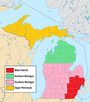


Metro Detroit highlighted in red

The following is a list of unincorporated communities in Metro Detroit in the U.S. state of Michigan.

With Detroit as the principal city, Metro Detroit is defined by the United States Census Bureau as consisting of 10 counties in southeast Michigan. The Detroit–Warren–Dearborn metropolitan statistical area (MSA) includes the six counties of Lapeer, Livingston, Macomb, Oakland, St. Clair, and Wayne. Additionally, Metro Detroit also consists of the Detroit–Warren–Ann Arbor combined statistical area (CSA), which includes the four outlying counties of Genesee, Lenawee, Monroe, and Washtenaw. At the 2020 census, the entire population of Metro Detroit was recorded at 5,325,219—ranking it as the 12th most-populated CSA in the country. This accounts for 52.8% of the state's total population of 10,077,331.

Although the area is heavily urbanized, there are still numerous unincorporated communities found within the region's 172 townships (116 civil townships and 56 charter townships). All unincorporated communities listed in this article are those that have a Geographic Names Information System (GNIS) identification listing the location as a populated place that is not within the boundaries of an incorporated city or village.[a] This article does not include ghost towns or communities that were once unincorporated but later included into a surrounding incorporated municipality. Census-designated places are also classified as unincorporated communities, and Metro Detroit contains 21 of the 212 census-designated places in Michigan.[1]

Bold Unincorporated communities listed in bold text link to their own respective Wikipedia articles.
Listings in regular text redirect back to the township article where it is located.
(CDP)
An unincorporated community that is also a census-designated place (CDP) at the 2020 census
These unincorporated communities contain an active post office and/or ZIP Code with the same name.
An unincorporated community that spans more than one county and may be listed more than once

Genesee County

edit
Genesee County
Community Coordinates GNIS ID
Argentine (CDP) 42°47′29″N 83°50′47″W / 42.7914188°N 83.8463430°W / 42.7914188; -83.8463430 (Argentine) 620210
Atlas This community contains an active post office with the same name. 42°56′16″N 83°32′04″W / 42.9378054°N 83.5343934°W / 42.9378054; -83.5343934 (Atlas) 620307
Bayport Park 42°51′15″N 83°43′04″W / 42.8541948°N 83.7177299°W / 42.8541948; -83.7177299 (Bayport Park) 620794
Beecher (CDP) 43°05′24″N 83°41′40″W / 43.0900266°N 83.6944022°W / 43.0900266; -83.6944022 (Beecher) 1616987
Brent Creek 43°07′04″N 83°53′12″W / 43.1178053°N 83.8866312°W / 43.1178053; -83.8866312 (Brent Creek) 621924
Duffield 42°55′41″N 83°54′36″W / 42.9280854°N 83.9099601°W / 42.9280854; -83.9099601 (Duffield) 624967
Farrandville 43°11′39″N 83°43′36″W / 43.1941922°N 83.7266274°W / 43.1941922; -83.7266274 (Farrandville) 625847
Genesee This community contains an active post office with the same name. 43°06′45″N 83°37′04″W / 43.1125262°N 83.6177333°W / 43.1125262; -83.6177333 (Genesee) 626714
Lake Fenton (CDP) 42°50′46″N 83°42′28″W / 42.8461392°N 83.7077293°W / 42.8461392; -83.7077293 (Lake Fenton) 1867319
Lakeside 42°50′09″N 83°42′24″W / 42.8358614°N 83.7066178°W / 42.8358614; -83.7066178 (Lakeside) 630021
Pine Run 43°10′40″N 83°42′51″W / 43.1778035°N 83.7141267°W / 43.1778035; -83.7141267 (Pine Run) 634995
Rankin 42°54′52″N 83°45′02″W / 42.9144723°N 83.7505107°W / 42.9144723; -83.7505107 (Rankin) 635636
Richfield Center 43°05′34″N 83°31′06″W / 43.0928041°N 83.5182850°W / 43.0928041; -83.5182850 (Richfield Center) 635878
Rogersville 43°07′22″N 83°34′37″W / 43.1228039°N 83.5768987°W / 43.1228039; -83.5768987 (Rogersville) 636124
Russellville 43°05′30″N 83°33′30″W / 43.0916931°N 83.5582864°W / 43.0916931; -83.5582864 (Russellville) 636408
Thetford Center 43°10′45″N 83°38′25″W / 43.1791923°N 83.6402353°W / 43.1791923; -83.6402353 (Thetford Center) 1614727
Whigville 42°56′41″N 83°39′03″W / 42.9446750°N 83.6508460°W / 42.9446750; -83.6508460 (Whigville) 2635529

Lapeer County

edit
Lapeer County
Community Coordinates GNIS ID
Attica (CDP) This community contains an active post office with the same name. 43°01′49″N 83°09′58″W / 43.0303053°N 83.1660514°W / 43.0303053; -83.1660514 (Attica) 620309
Barnes Lake (CDP) 43°11′00″N 83°18′08″W / 43.1831962°N 83.3022210°W / 43.1831962; -83.3022210 (Barnes Lake) 2804668
Barnes Lake–Millers Lake[b] 43°10′46″N 83°18′44″W / 43.1795601°N 83.3122954°W / 43.1795601; -83.3122954 (Barnes Lake-Millers Lake) 2393327
Burnside 43°12′38″N 83°04′38″W / 43.2105820°N 83.0771632°W / 43.2105820; -83.0771632 (Burnside) 622305
Elba 43°02′29″N 83°26′25″W / 43.041492°N 83.440262°W / 43.041492; -83.440262 (Elba) 625420
Farmers Creek 42°57′46″N 83°20′24″W / 42.9628058°N 83.3399442°W / 42.9628058; -83.3399442 (Farmers Creek) 625832
Goodland 43°05′41″N 83°04′21″W / 43.0947492°N 83.0724387°W / 43.0947492; -83.0724387 (Goodland) 1617590
Hadley This community contains an active post office with the same name. 42°57′16″N 83°24′12″W / 42.9544722°N 83.4032790°W / 42.9544722; -83.4032790 (Hadley) 627582
Hunters Creek 42°59′08″N 83°17′38″W / 42.9855835°N 83.2938322°W / 42.9855835; -83.2938322 (Hunters Creek) 628835
Kerr Hill 42°53′46″N 83°23′46″W / 42.8961395°N 83.3960555°W / 42.8961395; -83.3960555 (Kerr Hill) 1617657
Kings Mill 42°53′46″N 83°23′46″W / 42.8961395°N 83.3960555°W / 42.8961395; -83.3960555 (Kings Mill) 629717
Lum 43°05′58″N 83°09′04″W / 43.0994714°N 83.1510522°W / 43.0994714; -83.1510522 (Lum) 631209
Millers Lake (CDP) 43°10′46″N 83°19′27″W / 43.1795367°N 83.3240699°W / 43.1795367; -83.3240699 (Millers Lake) 2804672
SilverwoodThis community contains an active post office with the same name. 43°19′24″N 83°14′53″W / 43.3233576°N 83.2480026°W / 43.3233576; -83.2480026 (Silverwood) 637970
Thornville 42°56′33″N 83°13′26″W / 42.9425286°N 83.2238295°W / 42.9425286; -83.2238295 (Thornville) 1614802

Lenawee County

edit
Lenawee County
Manitou Beach–Devils Lake is a census-designated place that also contains three communities within its boundaries: Devils Lake, Geneva, and Manitou Beach.
Community Coordinates GNIS ID
Addison Junction 41°59′37″N 84°19′32″W / 41.99361°N 84.32556°W / 41.99361; -84.32556 (Addison Junction) 1617403
Birdsall 41°56′31″N 84°00′16″W / 41.94194°N 84.00444°W / 41.94194; -84.00444 (Birdsall) 621441
Cadmus 41°52′26″N 84°09′38″W / 41.87389°N 84.16056°W / 41.87389; -84.16056 (Cadmus) 622433
Cambridge Junction 42°03′32″N 84°13′16″W / 42.05889°N 84.22111°W / 42.05889; -84.22111 (Cambridge Junction) 622506
Canandaigua 41°47′55″N 84°14′04″W / 41.79861°N 84.23444°W / 41.79861; -84.23444 (Canandaigua) 622682
Devil's Lake Estates 41°58′59″N 84°18′22″W / 41.98306°N 84.30611°W / 41.98306; -84.30611 (Devil's Lake Estates) 2465635
Devils Lake 42°00′28″N 84°17′33″W / 42.00778°N 84.29250°W / 42.00778; -84.29250 (Devils Lake) 624605
Fairfield 41°48′46″N 84°02′28″W / 41.81278°N 84.04111°W / 41.81278; -84.04111 (Fairfield) 625749
Geneva 41°57′29″N 84°16′50″W / 41.95806°N 84.28056°W / 41.95806; -84.28056 (Geneva) 626720
Holloway 41°56′06″N 83°54′52″W / 41.93500°N 83.91444°W / 41.93500; -83.91444 (Holloway) 628437
Jasper (CDP) This community contains an active post office with the same name. 41°47′36″N 84°02′26″W / 41.79333°N 84.04056°W / 41.79333; -84.04056 (Jasper) 629217
Lenawee Junction 41°53′04″N 83°56′38″W / 41.88444°N 83.94389°W / 41.88444; -83.94389 (Lenawee Junction) 1617679
Lime Creek 41°45′56″N 84°19′47″W / 41.76556°N 84.32972°W / 41.76556; -84.32972 (Lime Creek) 1617682
Macon 42°03′59″N 83°52′06″W / 42.06639°N 83.86833°W / 42.06639; -83.86833 (Macon) 631303
Madison Center 41°51′36″N 84°02′33″W / 41.86000°N 84.04250°W / 41.86000; -84.04250 (Madison Center) 631308
Manitou Beach This community contains an active post office with the same name. 41°58′12″N 84°18′30″W / 41.97000°N 84.30833°W / 41.97000; -84.30833 (Manitou Beach) 631388
Manitou Beach–Devils Lake (CDP) 41°58′43″N 84°17′08″W / 41.97861°N 84.28556°W / 41.97861; -84.28556 (Manitou Beach-Devils Lake) 2393118
Medina 41°48′29″N 84°15′50″W / 41.80806°N 84.26389°W / 41.80806; -84.26389 (Medina) 632069
Mulberry 41°44′37″N 83°52′54″W / 41.74361°N 83.88167°W / 41.74361; -83.88167 (Mulberry) 633095
Munson 41°42′41″N 84°19′45″W / 41.71139°N 84.32917°W / 41.71139; -84.32917 (Munson) 633128
Newburg 42°02′32″N 83°58′06″W / 42.04222°N 83.96833°W / 42.04222; -83.96833 (Newburg) 633095
North Morenci 41°45′49″N 84°13′25″W / 41.76361°N 84.22361°W / 41.76361; -84.22361 (North Morenci) 633615
Oak Shade Park 42°04′06″N 84°09′38″W / 42.06833°N 84.16056°W / 42.06833; -84.16056 (Oak Shade Park) 633863
Ogden 41°49′04″N 83°58′48″W / 41.81778°N 83.98000°W / 41.81778; -83.98000 (Ogden) 633948
Ogden Center 41°46′19″N 83°57′35″W / 41.77194°N 83.95972°W / 41.77194; -83.95972 (Ogden Center) 633949
Palmyra This community contains an active post office with the same name. 41°51′35″N 83°56′09″W / 41.85972°N 83.93583°W / 41.85972; -83.93583 (Palmyra) 634331
Raisin Center 41°55′44″N 83°57′12″W / 41.92889°N 83.95333°W / 41.92889; -83.95333 (Raisin Center) 1617809
Ridgeville 41°45′26″N 84°01′18″W / 41.75722°N 84.02167°W / 41.75722; -84.02167 (Ridgeville) 1617818
Ridgeway 41°59′38″N 83°51′46″W / 41.99389°N 83.86278°W / 41.99389; -83.86278 (Ridgeway) 635909
Riga This community contains an active post office with the same name. 41°48′33″N 83°49′30″W / 41.80917°N 83.82500°W / 41.80917; -83.82500 (Riga) 635922
Rollin 41°54′43″N 84°19′25″W / 41.91194°N 84.32361°W / 41.91194; -84.32361 (Rollin) 636133
Rome Center 41°56′37″N 84°11′16″W / 41.94361°N 84.18778°W / 41.94361; -84.18778 (Rome Center) 636144
Round Lake Estates 41°57′50″N 84°17′20″W / 41.96389°N 84.28889°W / 41.96389; -84.28889 (Round Lake Estates) 2465636
Sand Creek This community contains an active post office with the same name. 41°49′33″N 84°06′05″W / 41.82583°N 84.10139°W / 41.82583; -84.10139 (Sand Creek) 637163
Seneca 41°47′15″N 84°10′36″W / 41.78750°N 84.17667°W / 41.78750; -84.17667 (Seneca) 637574
South Fairfield 41°43′43″N 83°58′38″W / 41.72861°N 83.97722°W / 41.72861; -83.97722 (South Fairfield) 1617858
Southland 41°43′51″N 83°46′59″W / 41.73083°N 83.78306°W / 41.73083; -83.78306 (Southland) 638449
Springville 42°02′00″N 84°10′16″W / 42.03333°N 84.17111°W / 42.03333; -84.17111 (Springville) 638633
Tipton This community contains an active post office with the same name. 42°01′00″N 84°03′51″W / 42.01667°N 84.06417°W / 42.01667; -84.06417 (Tipton) 1614882
Wellsville 41°53′04″N 83°53′08″W / 41.88444°N 83.88556°W / 41.88444; -83.88556 (Wellsville) 1617927
Weston This community contains an active post office with the same name. 41°46′13″N 84°05′52″W / 41.77028°N 84.09778°W / 41.77028; -84.09778 (Weston) 1616220

Livingston County

edit
Livingston County
Noted for its unusual name, Hell dates back to the 1830s. The community is located along D-32 within Putnam Township.
Community Coordinates GNIS ID
Anderson 42°28′15″N 84°00′22″W / 42.4708678°N 84.0060601°W / 42.4708678; -84.0060601 (Anderson) 1617416
Bullis Crossing 42°28′04″N 84°01′59″W / 42.4678125°N 84.0330062°W / 42.4678125; -84.0330062 (Bullis Crossing) 1617465
Chalkerville 42°25′56″N 84°01′07″W / 42.4322572°N 84.0185602°W / 42.4322572; -84.0185602 (Chalkerville) 623044
Cohoctah This community contains an active post office with the same name. 42°45′35″N 83°56′55″W / 42.7597542°N 83.9485679°W / 42.7597542; -83.9485679 (Cohoctah) 623544
Cohoctah Center 42°45′06″N 83°59′39″W / 42.751796°N 83.994256°W / 42.751796; -83.994256 (Cohoctah Center) 1623164
Deer Creek 42°45′36″N 83°54′26″W / 42.7600313°N 83.9071775°W / 42.7600313; -83.9071775 (Deer Creek) 1617518
Deerfield Center 42°44′01″N 83°51′44″W / 42.7336418°N 83.8621750°W / 42.7336418; -83.8621750 (Deerfield Center) 624497
Fleming 42°38′37″N 84°00′48″W / 42.6436447°N 84.0132884°W / 42.6436447; -84.0132884 (Fleming) 626152
Green Oak 42°29′33″N 83°41′53″W / 42.4925336°N 83.6979962°W / 42.4925336; -83.6979962 (Green Oak) 627318
Gregory This community contains an active post office with the same name. 42°27′30″N 84°05′04″W / 42.4583684°N 84.0843979°W / 42.4583684; -84.0843979 (Gregory) 627403
Hallers Corners 42°41′41″N 83°42′13″W / 42.6947518°N 83.7035577°W / 42.6947518; -83.7035577 (Hallers Corners) 627655
Hamburg This community contains an active post office with the same name. 42°26′55″N 83°48′06″W / 42.4486456°N 83.8016097°W / 42.4486456; -83.8016097 (Hamburg) 627670
Hartland (CDP) This community contains an active post office with the same name. 42°39′24″N 83°45′11″W / 42.6566970°N 83.7530022°W / 42.6566970; -83.7530022 (Hartland) 627882
Hell 42°26′05″N 83°59′06″W / 42.4347571°N 83.9849477°W / 42.4347571; -83.9849477 (Hell) 628065
Kaiserville 42°25′54″N 84°01′49″W / 42.4317018°N 84.0302276°W / 42.4317018; -84.0302276 (Kaiserville) 629437
Lakeland This community contains an active post office with the same name. 42°27′48″N 83°50′39″W / 42.4633676°N 83.8441109°W / 42.4633676; -83.8441109 (Lakeland) 630012
Nicholson 42°46′37″N 84°07′26″W / 42.7769773°N 84.1238528°W / 42.7769773; -84.1238528 (Nicholson) 1617743
Oak Grove 42°42′01″N 83°55′55″W / 42.7003100°N 83.9318985°W / 42.7003100; -83.9318985 (Oak Grove) 633813
Parishfield 42°29′48″N 83°49′48″W / 42.4967003°N 83.829944°W / 42.4967003; -83.829944 (Parishfield) 1617769
Parkers Corners 42°34′05″N 84°06′48″W / 42.5680902°N 84.1132915°W / 42.5680902; -84.1132915 (Parkers Corners) 634396
Parshallville 42°41′31″N 83°46′56″W / 42.6919745°N 83.7821709°W / 42.6919745; -83.7821709 (Parshallville) 634431
Pettysville 42°28′31″N 83°52′10″W / 42.4753119°N 83.8693894°W / 42.4753119; -83.8693894 (Pettysville) 634741
Plainfield 42°29′49″N 84°06′27″W / 42.4969793°N 84.1074559°W / 42.4969793; -84.1074559 (Plainfield) 635068
Rushton 42°27′07″N 83°41′46″W / 42.4519788°N 83.6960516°W / 42.4519788; -83.6960516 (Rushton) 636398
Unadilla 42°25′43″N 84°03′24″W / 42.4286463°N 84.0566179°W / 42.4286463; -84.0566179 (Unadilla) 1615318
Whitmore Lake(CDP) This community contains an active post office with the same name. 42°26′22″N 83°44′38″W / 42.4394790°N 83.7438303°W / 42.4394790; -83.7438303 (Whitmore Lake) 1616386
Williamsville 42°26′20″N 84°05′48″W / 42.4389241°N 84.0966204°W / 42.4389241; -84.0966204 (Williamsville) 1616517

Macomb County

edit
Macomb County
Community Coordinates GNIS ID
Anchor Bay Gardens 42°38′34″N 82°48′45″W / 42.6428109°N 82.8124187°W / 42.6428109; -82.8124187 (Anchor Bay Gardens) 620078
Anchor Bay Harbor 42°39′19″N 82°47′57″W / 42.6553107°N 82.7990854°W / 42.6553107; -82.7990854 (Anchor Bay Harbor) 620079
Anchor Bay Shores 42°38′08″N 82°49′00″W / 42.6355889°N 82.8165853°W / 42.6355889; -82.8165853 (Anchor Bay Shores) 620081
Broad Acres 42°32′57″N 82°54′08″W / 42.5492017°N 82.9021412°W / 42.5492017; -82.9021412 (Broad Acres) 622014
Cady 42°33′37″N 82°57′52″W / 42.5603126°N 82.9643666°W / 42.5603126; -82.9643666 (Cady) 622436
Chesterfield 42°39′46″N 82°50′33″W / 42.6628105°N 82.8424208°W / 42.6628105; -82.8424208 (Chesterfield) 623172
Chesterfield Shores 42°40′12″N 82°45′41″W / 42.6700326°N 82.7613066°W / 42.6700326; -82.7613066 (Chesterfield Shores) 623174
Clifton Mill 42°47′06″N 83°05′10″W / 42.7850306°N 83.0860450°W / 42.7850306; -83.0860450 (Clifton Mill) 1617492
Clinton 42°35′13″N 82°55′12″W / 42.5869787°N 82.9199212°W / 42.5869787; -82.9199212 (Clinton) 1867316
Davis 42°43′51″N 82°57′37″W / 42.7308646°N 82.9602060°W / 42.7308646; -82.9602060 (Davis) 624333
Disco 42°41′02″N 83°02′04″W / 42.6839212°N 83.0343737°W / 42.6839212; -83.0343737 (Disco) 624694
Lakeside 42°33′54″N 82°50′21″W / 42.5650347°N 82.8390835°W / 42.5650347; -82.8390835 (Lakeside) 1617669
Lottivue 42°39′34″N 82°45′43″W / 42.6594772°N 82.7618617°W / 42.6594772; -82.7618617 (Lottivue) 631117
Macomb This community contains an active post office with the same name. 42°42′03″N 82°57′33″W / 42.7008653°N 82.9590938°W / 42.7008653; -82.9590938 (Macomb) 631290
Meade 42°43′04″N 82°52′28″W / 42.7178094°N 82.8743687°W / 42.7178094; -82.8743687 (Meade) 632042
Milton 42°41′21″N 82°49′19″W / 42.6891989°N 82.8218654°W / 42.6891989; -82.8218654 (Milton) 632433
Mount Vernon 42°44′31″N 83°05′13″W / 42.7419756°N 83.0868775°W / 42.7419756; -83.0868775 (Mount Vernon) 632843
Point Lakeview 42°39′21″N 82°46′45″W / 42.6558662°N 82.7790845°W / 42.6558662; -82.7790845 (Point Lakeview) 635187
Preston Corners 42°41′58″N 82°59′45″W / 42.6994764°N 82.9957619°W / 42.6994764; -82.9957619 (Preston Corners) 635439
Ray Center 42°45′42″N 82°54′05″W / 42.7616975°N 82.9013157°W / 42.7616975; -82.9013157 (Ray Center) 635677
Saint Clair Haven 42°35′00″N 82°47′25″W / 42.5833676°N 82.7901932°W / 42.5833676; -82.7901932 (Saint Clair Haven) 636597
Sebille Manor 42°39′40″N 82°48′44″W / 42.6611439°N 82.8121417°W / 42.6611439; -82.8121417 (Sebille Manor) 637515
Shelby 42°40′15″N 83°01′59″W / 42.6708659°N 83.0329844°W / 42.6708659; -83.0329844 (Shelby) 1867322
Waldenburg 42°39′26″N 82°56′15″W / 42.6572550°N 82.9374246°W / 42.6572550; -82.9374246 (Waldenburg) 1615682
Washington This community contains an active post office with the same name. 42°43′28″N 83°02′10″W / 42.7244759°N 83.0360419°W / 42.7244759; -83.0360419 (Washington) 1615796
Wolcott Mills 42°46′08″N 82°55′37″W / 42.7689196°N 82.9268724°W / 42.7689196; -82.9268724 (Wolcott Mills) 1616678
Yates 42°40′25″N 83°05′45″W / 42.6736436°N 83.0957643°W / 42.6736436; -83.0957643 (Yates) 1617957

Monroe County

edit
Monroe County
The community of Erie was settled as early as 1790 in the Northwest Territory. The community has its own post office that has remained in service since 1827.
Community Coordinates GNIS ID
Avalon Beach 41°51′26″N 83°23′34″W / 41.85722°N 83.39278°W / 41.85722; -83.39278 (Avalon Beach) 620371
Azalia This community contains an active post office with the same name. 42°01′08″N 83°39′57″W / 42.01889°N 83.66583°W / 42.01889; -83.66583 (Azalia) 620397
Bolles Harbor 41°52′03″N 83°23′10″W / 41.86750°N 83.38611°W / 41.86750; -83.38611 (Bolles Harbor) 621693
Cone 42°01′55″N 83°45′11″W / 42.03194°N 83.75306°W / 42.03194; -83.75306 (Cone) 623689
Detroit Beach (CDP) 41°55′52″N 83°19′37″W / 41.93111°N 83.32694°W / 41.93111; -83.32694 (Detroit Beach) 624581
Diann 41°55′55″N 83°38′14″W / 41.93194°N 83.63722°W / 41.93194; -83.63722 (Diann) 1517525
Erie This community contains an active post office with the same name. 41°47′39″N 83°29′47″W / 41.79417°N 83.49639°W / 41.79417; -83.49639 (Erie) 625631
Evergreen Acres 41°54′26″N 83°25′52″W / 41.90722°N 83.43111°W / 41.90722; -83.43111 (Evergreen Acres) 625688
Exeter 42°02′48″N 83°29′58″W / 42.04667°N 83.49944°W / 42.04667; -83.49944 (Exeter) 2438738
Golfcrest 41°56′34″N 83°22′13″W / 41.94278°N 83.37028°W / 41.94278; -83.37028 (Golfcrest) 626933
Grafton 42°02′12″N 83°23′23″W / 42.03667°N 83.38972°W / 42.03667; -83.38972 (Grafton) 1617593
Grand View 41°50′31″N 83°24′10″W / 41.84194°N 83.40278°W / 41.84194; -83.40278 (Grand View) 627117
Grape 41°57′49″N 83°32′22″W / 41.96361°N 83.53944°W / 41.96361; -83.53944 (Grape) 627162
Hillcrest Orchard 41°50′58″N 83°28′36″W / 41.84944°N 83.47667°W / 41.84944; -83.47667 (Hillcrest Orchard) 628302
Ida (CDP) This community contains an active post office with the same name. 41°54′39″N 83°34′25″W / 41.91083°N 83.57361°W / 41.91083; -83.57361 (Ida) 628919
Ida Center 41°51′58″N 83°34′17″W / 41.86611°N 83.57139°W / 41.86611; -83.57139 (Ida Center) 1617637
La Salle This community contains an active post office with the same name. 41°52′04″N 83°27′08″W / 41.86778°N 83.45222°W / 41.86778; -83.45222 (La Salle) 629918
Lambertville (CDP) This community contains an active post office with the same name. 41°45′57″N 83°37′41″W / 41.76583°N 83.62806°W / 41.76583; -83.62806 (Lambertville) 630097
Liberty Corners 41°44′59″N 83°35′14″W / 41.74972°N 83.58722°W / 41.74972; -83.58722 (Liberty Corners) 630367
London 42°01′12″N 83°36′48″W / 42.02000°N 83.61333°W / 42.02000; -83.61333 (London) 630890
Lulu 41°52′47″N 83°36′39″W / 41.87972°N 83.61083°W / 41.87972; -83.61083 (Lulu) 631207
Newport This community contains an active post office with the same name. 42°00′08″N 83°18′31″W / 42.00222°N 83.30861°W / 42.00222; -83.30861 (Newport) 633372
North Shores 41°50′11″N 83°24′27″W / 41.83639°N 83.40750°W / 41.83639; -83.40750 (North Shores) 633655
Oakville 42°04′53″N 83°34′51″W / 42.08139°N 83.58083°W / 42.08139; -83.58083 (Oakville) 633905
Oldport 41°59′41″N 83°17′12″W / 41.99472°N 83.28667°W / 41.99472; -83.28667 (Oldport) 634021
Ottawa 41°46′02″N 83°31′17″W / 41.76722°N 83.52139°W / 41.76722; -83.52139 (Ottawa) 1617764
Ottawa Lake This community contains an active post office with the same name. 41°45′51″N 83°44′51″W / 41.76417°N 83.74750°W / 41.76417; -83.74750 (Ottawa Lake) none[a]
Patterson Gardens 41°55′06″N 83°25′50″W / 41.91833°N 83.43056°W / 41.91833; -83.43056 (Patterson Gardens) 634469
Petersburg Junction 41°53′07″N 83°42′09″W / 41.88528°N 83.70250°W / 41.88528; -83.70250 (Petersburg Junction) 1617782
Pointe aux Peaux 41°56′42″N 83°15′15″W / 41.94500°N 83.25417°W / 41.94500; -83.25417 (Pointe aux Peaux) 1617005
Rea 41°58′31″N 83°43′18″W / 41.97528°N 83.72167°W / 41.97528; -83.72167 (Rea) 2438719
Saint Anthony 41°47′57″N 83°39′21″W / 41.79917°N 83.65583°W / 41.79917; -83.65583 (Saint Anthony) 636541
Samaria This community contains an active post office with the same name. 41°48′29″N 83°34′42″W / 41.80806°N 83.57833°W / 41.80806; -83.57833 (Samaria) 637149
Scofield 42°01′17″N 83°28′55″W / 42.02139°N 83.48194°W / 42.02139; -83.48194 (Scofield) 637454
South Monroe (CDP) 41°53′45″N 83°25′04″W / 41.89583°N 83.41778°W / 41.89583; -83.41778 (South Monroe) 1867324
Steiner 41°59′20″N 83°23′15″W / 41.98889°N 83.38750°W / 41.98889; -83.38750 (Steiner) 638786
Stony Creek 41°57′51″N 83°20′03″W / 41.96417°N 83.33417°W / 41.96417; -83.33417 (Stony Creek) 638890
Stony Point (CDP) 41°56′29″N 83°15′54″W / 41.94139°N 83.26500°W / 41.94139; -83.26500 (Stony Point) 638920
Strasburg 41°54′51″N 83°30′09″W / 41.91417°N 83.50250°W / 41.91417; -83.50250 (Strasburg) 638938
Temperance (CDP) This community contains an active post office with the same name. 41°46′45″N 83°34′08″W / 41.77917°N 83.56889°W / 41.77917; -83.56889 (Temperance) 1614669
Vienna 41°47′13″N 83°28′41″W / 41.78694°N 83.47806°W / 41.78694; -83.47806 (Vienna) 1617913
Vienna Junction 41°45′00″N 83°30′18″W / 41.75000°N 83.50500°W / 41.75000; -83.50500 (Vienna Junction) 1617914
West Monroe (CDP) 41°54′50″N 83°25′54″W / 41.91389°N 83.43167°W / 41.91389; -83.43167 (West Monroe) 1867326
Whiteford Center 41°46′36″N 83°40′59″W / 41.77667°N 83.68306°W / 41.77667; -83.68306 (Whiteford Center) 1616360
Woodland Beach (CDP) 41°56′24″N 83°18′48″W / 41.94000°N 83.31333°W / 41.94000; -83.31333 (Woodland Beach) 1616752
Yargerville 41°50′18″N 83°31′55″W / 41.83833°N 83.53194°W / 41.83833; -83.53194 (Yargerville) 1616874

Oakland County

edit
Oakland County
Community Coordinates GNIS ID
Andersonville 42°43′48″N 83°29′33″W / 42.7300290°N 83.4924428°W / 42.7300290; -83.4924428 (Andersonville) 620113
Austin Corners 42°47′16″N 83°30′29″W / 42.7878061°N 83.5080002°W / 42.7878061; -83.5080002 (Austin Corners) 620358
Brandon Gardens 42°49′32″N 83°26′37″W / 42.8255842°N 83.4435551°W / 42.8255842; -83.4435551 (Brandon Gardens) 621887
Campbells Corner 42°47′59″N 83°08′01″W / 42.7997527°N 83.1335468°W / 42.7997527; -83.1335468 (Campbells Corner) 622669
Charing Cross 42°34′18″N 83°13′17″W / 42.5717008°N 83.2213204°W / 42.5717008; -83.2213204 (Charing Cross) 1617483
Clintonville 42°41′25″N 83°21′22″W / 42.6903090°N 83.3560499°W / 42.6903090; -83.3560499 (Clintonville) 623486
Clyde 42°40′51″N 83°37′05″W / 42.6808632°N 83.6179998°W / 42.6808632; -83.6179998 (Clyde) 623506
Commerce 42°35′28″N 83°29′27″W / 42.5911431°N 83.4907721°W / 42.5911431; -83.4907721 (Commerce) 623657
Davisburg 42°45′08″N 83°32′28″W / 42.752223°N 83.541234°W / 42.752223; -83.541234 (Davisburg) 624352
Drayton Plains 42°41′03″N 83°22′38″W / 42.6841978°N 83.3771613°W / 42.6841978; -83.3771613 (Drayton Plains) 624880
East Highland 42°39′18″N 83°34′18″W / 42.6550305°N 83.5716091°W / 42.6550305; -83.5716091 (East Highland) 625193
Five Points 42°48′50″N 83°36′37″W / 42.8139171°N 83.6102257°W / 42.8139171; -83.6102257 (Five Points) 1617558
Four Towns 42°37′04″N 83°24′49″W / 42.6178099°N 83.4135489°W / 42.6178099; -83.4135489 (Four Towns) 626335
Gingellville 42°43′18″N 83°18′28″W / 42.7216979°N 83.3077167°W / 42.7216979; -83.3077167 (Gingellville) 626847
Glengary 42°33′54″N 83°30′15″W / 42.5650325°N 83.5041050°W / 42.5650325; -83.5041050 (Glengary) 626883
Goodison 42°43′58″N 83°09′45″W / 42.7328093°N 83.1624353°W / 42.7328093; -83.1624353 (Goodison) 626946
Groveland Corners 42°48′58″N 83°32′52″W / 42.8161393°N 83.5477241°W / 42.8161393; -83.5477241 (Groveland Corners) 1625569
Hickory Ridge 42°40′47″N 83°39′54″W / 42.6797521°N 83.6649452°W / 42.6797521; -83.6649452 (Hickory Ridge) 628196
Highland 42°38′17″N 83°37′02″W / 42.6380864°N 83.6171651°W / 42.6380864; -83.6171651 (Highland) 628244
Jossman Acres 42°45′53″N 83°28′15″W / 42.7647510°N 83.4707766°W / 42.7647510; -83.4707766 (Jossman Acres) 629404
Lake Orion Heights 42°46′13″N 83°15′51″W / 42.7703087°N 83.2641061°W / 42.7703087; -83.2641061 (Lake Orion Heights) 629990
Lakeville This community contains an active post office and/or ZIP Code with the same name. 42°49′17″N 83°09′01″W / 42.8214191°N 83.1502144°W / 42.8214191; -83.1502144 (Lakeville) 630067
New Hudson 42°30′39″N 83°36′56″W / 42.5108667°N 83.6154948°W / 42.5108667; -83.6154948 (New Hudson) 633327
Newark 42°51′36″N 83°37′31″W / 42.8600280°N 83.6252274°W / 42.8600280; -83.6252274 (Newark) 1617742
Oak Grove 42°37′13″N 83°14′21″W / 42.6203111°N 83.2391005°W / 42.6203111; -83.2391005 (Oak Grove) 633815
Oakley Park 42°34′08″N 83°29′48″W / 42.5689214°N 83.4966050°W / 42.5689214; -83.4966050 (Oakley Park) 633891
Oakwood 42°52′03″N 83°20′12″W / 42.8675291°N 83.3366091°W / 42.8675291; -83.3366091 (Oakwood) 633908
Oxbow 42°38′26″N 83°28′23″W / 42.6405867°N 83.4729954°W / 42.6405867; -83.4729954 (Oxbow) 634258
Perry Lake Heights 42°49′40″N 83°24′04″W / 42.8278068°N 83.4010543°W / 42.8278068; -83.4010543 (Perry Lake Heights) 634675
Rose Center 42°43′54″N 83°37′06″W / 42.7317600°N 83.6183200°W / 42.7317600; -83.6183200 (Rose Center) 2648736
Rose Corners 42°44′22″N 83°40′00″W / 42.7394731°N 83.6666137°W / 42.7394731; -83.6666137 (Rose Corners) 636194
Rudds Mill 42°46′04″N 83°13′06″W / 42.7678088°N 83.2182713°W / 42.7678088; -83.2182713 (Rudds Mill) 1617829
Seven Harbors 42°40′19″N 83°34′20″W / 42.6719745°N 83.5721651°W / 42.6719745; -83.5721651 (Seven Harbors) 1621565
Springfield 42°44′58″N 83°28′25″W / 42.7494732°N 83.4735541°W / 42.7494732; -83.4735541 (Springfield) 638623
Thomas 42°52′46″N 83°17′50″W / 42.8794736°N 83.2971639°W / 42.8794736; -83.2971639 (Thomas) 1614749
Union Lake This community contains an active post office and/or ZIP Code with the same name. 42°36′53″N 83°26′49″W / 42.6147541°N 83.4468828°W / 42.6147541; -83.4468828 (Union Lake) 1615347
Walters 42°45′50″N 83°20′29″W / 42.7639191°N 83.3413297°W / 42.7639191; -83.3413297 (Walters) 1615742
Waterford This community contains an active post office and/or ZIP Code with the same name. 42°42′08″N 83°24′10″W / 42.7022527°N 83.4027180°W / 42.7022527; -83.4027180 (Waterford) 1615842
Waterstone 42°50′11″N 83°17′06″W / 42.8364823°N 83.2850790°W / 42.8364823; -83.2850790 (Waterstone) 2680600
West Highland 42°38′10″N 83°39′44″W / 42.6361419°N 83.6621661°W / 42.6361419; -83.6621661 (West Highland) 1616122
Westacres 42°36′00″N 83°25′30″W / 42.6000323°N 83.4249375°W / 42.6000323; -83.4249375 (Westacres) 1616986
White Lake 42°41′30″N 83°33′15″W / 42.6916964°N 83.5541098°W / 42.6916964; -83.5541098 (White Lake) 1616318
Yates 42°40′25″N 83°05′45″W / 42.6736436°N 83.0957643°W / 42.6736436; -83.0957643 (Yates) 1617957

St. Clair County

edit
St. Clair County
The insular community of Sans Souci may also be referred to as Harsens Island, which is the name of the post office that serves the surrounding area.
Settled as early as 1840 as a railway station, Adair is a small community within Casco Township.
Community Coordinates GNIS ID
Abbottsford 43°01′12″N 82°38′00″W / 43.0200280°N 82.6332564°W / 43.0200280; -82.6332564 (Abbottsford) 1624336
Adair 42°47′53″N 82°38′02″W / 42.7980869°N 82.6338065°W / 42.7980869; -82.6338065 (Adair) 1624337
Allenton This community contains an active post office with the same name. 42°55′10″N 82°56′44″W / 42.9194730°N 82.9454870°W / 42.9194730; -82.9454870 (Allenton) 1624348
Anchorville This community contains an active post office with the same name. 42°41′28″N 82°41′19″W / 42.6911437°N 82.6885269°W / 42.6911437; -82.6885269 (Anchorville) 1624352
Atkins 43°03′47″N 82°34′37″W / 43.0630836°N 82.5768666°W / 43.0630836; -82.5768666 (Atkins) 1624357
Avalon Beach 42°41′20″N 82°30′30″W / 42.6889225°N 82.5082425°W / 42.6889225; -82.5082425 (Avalon Beach) 1624358
Avoca This community contains an active post office with the same name. 43°03′43″N 82°41′28″W / 43.0619715°N 82.6910367°W / 43.0619715; -82.6910367 (Avoca) 1624359
Bedore 42°33′28″N 82°36′47″W / 42.5578126°N 82.6129630°W / 42.5578126; -82.6129630 (Bedore) 1624378
Belle River 42°49′25″N 82°42′01″W / 42.8236415°N 82.7001983°W / 42.8236415; -82.7001983 (Belle River) 1624380
Berville 42°54′30″N 82°52′59″W / 42.9083621°N 82.8829846°W / 42.9083621; -82.8829846 (Berville) 1624388
Blaine 43°06′57″N 82°34′51″W / 43.1158607°N 82.5807565°W / 43.1158607; -82.5807565 (Blaine) 1624399
Broadbridge Station 42°40′43″N 82°30′43″W / 42.6786448°N 82.5118533°W / 42.6786448; -82.5118533 (Broadbridge Station) 1624417
Brockway 43°04′28″N 82°45′56″W / 43.0744710°N 82.7654837°W / 43.0744710; -82.7654837 (Brockway) 1624419
Casco 42°45′09″N 82°40′18″W / 42.7525317°N 82.6715845°W / 42.7525317; -82.6715845 (Casco) 1624444
Cherry Beach 42°41′05″N 82°30′35″W / 42.6847559°N 82.5096313°W / 42.6847559; -82.5096313 (Cherry Beach) 1624453
Clays Landing 42°33′06″N 82°36′16″W / 42.5517016°N 82.6043512°W / 42.5517016; -82.6043512 (Clays Landing) 1624457
Columbus 42°52′56″N 82°39′45″W / 42.8822520°N 82.6624207°W / 42.8822520; -82.6624207 (Columbus) 1624465
Copeland Corner 42°40′21″N 82°37′21″W / 42.6725332°N 82.6224126°W / 42.6725332; -82.6224126 (Copeland Corner) 1624474
Fair Haven This community contains an active post office with the same name. 42°40′45″N 82°39′14″W / 42.6791996°N 82.6538030°W / 42.6791996; -82.6538030 (Fair Haven) 1624519
Fargo 43°06′11″N 82°39′33″W / 43.1030825°N 82.6590920°W / 43.1030825; -82.6590920 (Fargo) 1624522
Forster 42°33′40″N 82°37′06″W / 42.5611459°N 82.6182410°W / 42.5611459; -82.6182410 (Forster) 1624546
Gardendale 43°02′19″N 82°29′33″W / 43.0386399°N 82.4924191°W / 43.0386399; -82.4924191 (Gardendale) 1624556
Goodells This community contains an active post office with the same name. 42°58′52″N 82°39′57″W / 42.9811394°N 82.6657566°W / 42.9811394; -82.6657566 (Goodells) 1624564
Grande Pointe 42°35′58″N 82°32′43″W / 42.5994788°N 82.5451844°W / 42.5994788; -82.5451844 (Grande Pointe) 1624574
Harsens Island This community contains an active post office with the same name. 42°35′01″N 82°33′46″W / 42.5835620°N 82.5628360°W / 42.5835620; -82.5628360 (Harsens Island) none[a]
Hawthorne 42°46′24″N 82°28′22″W / 42.7733661°N 82.4726887°W / 42.7733661; -82.4726887 (Hawthorne) 1624599
Jeddo This community contains an active post office with the same name. 43°09′06″N 82°35′00″W / 43.1516937°N 82.5832572°W / 43.1516937; -82.5832572 (Jeddo) 1624628
Keewahdin 43°02′23″N 82°26′40″W / 43.0397514°N 82.4443611°W / 43.0397514; -82.4443611 (Keewahdin) 1624639
Kimball 42°56′53″N 82°33′45″W / 42.9480851°N 82.5624192°W / 42.9480851; -82.5624192 (Kimball) 1624643
Lakeport (CDP) 43°06′54″N 82°29′25″W / 43.1150282°N 82.4901982°W / 43.1150282; -82.4901982 (Lakeport) 1624657
Lambs 42°55′58″N 82°42′30″W / 42.9328065°N 82.7082567°W / 42.9328065; -82.7082567 (Lambs) 1624663
Lesterville 42°57′28″N 82°54′20″W / 42.9578059°N 82.9054863°W / 42.9578059; -82.9054863 (Lesterville) 1624676
Maple Leaf 42°34′41″N 82°34′11″W / 42.5780902°N 82.5696288°W / 42.5780902; -82.5696288 (Maple Leaf) 1624704
Martindale Beach 42°41′29″N 82°30′27″W / 42.6914225°N 82.5074093°W / 42.6914225; -82.5074093 (Martindale Beach) 1624714
Merrillsville 43°09′00″N 82°48′50″W / 43.1500000°N 82.8138889°W / 43.1500000; -82.8138889 (Merrillsville) 2582232
Miller 42°32′57″N 82°39′32″W / 42.5492017°N 82.6587976°W / 42.5492017; -82.6587976 (Miller) 1624743
Muirs 42°33′23″N 82°35′14″W / 42.5564238°N 82.5871285°W / 42.5564238; -82.5871285 (Muirs) 1624771
North Lakeport 43°08′14″N 82°29′49″W / 43.1372501°N 82.4968655°W / 43.1372501; -82.4968655 (North Lakeport) 1624789
North Street This community contains an active post office with the same name. 43°03′36″N 82°31′48″W / 43.0600050°N 82.5300330°W / 43.0600050; -82.5300330 (North Street) none[a]
Pearl Beach (CDP) 42°37′36″N 82°35′52″W / 42.6267006°N 82.5976876°W / 42.6267006; -82.5976876 (Pearl Beach) 1624814
Perch Point 42°39′54″N 82°37′13″W / 42.6650333°N 82.6201900°W / 42.6650333; -82.6201900 (Perch Point) 1624817
Peters 42°44′40″N 82°37′54″W / 42.7444765°N 82.6315828°W / 42.7444765; -82.6315828 (Peters) 1624819
Pointe aux Tremble 42°37′17″N 82°34′16″W / 42.6214230°N 82.5710196°W / 42.6214230; -82.5710196 (Pointe aux Tremble) 1624836
Rattle Run 42°51′59″N 82°35′59″W / 42.8664194°N 82.5996404°W / 42.8664194; -82.5996404 (Rattle Run) 1624852
Riley Center 42°56′27″N 82°50′30″W / 42.9408616°N 82.8415949°W / 42.9408616; -82.8415949 (Riley Center) 1624857
Riverside 42°33′32″N 82°37′49″W / 42.5589237°N 82.6301859°W / 42.5589237; -82.6301859 (Riverside) 1624861
Roberts Landing 42°39′35″N 82°30′57″W / 42.6597561°N 82.5157415°W / 42.6597561; -82.5157415 (Roberts Landing) 1624867
Ruby (CDP) 43°02′32″N 82°36′27″W / 43.0422502°N 82.6074227°W / 43.0422502; -82.6074227 (Ruby) 1624873
Sans Souci 42°34′52″N 82°33′44″W / 42.5811490°N 82.5621580°W / 42.5811490; -82.5621580 (Sans Souci) 1624914
Smiths Creek This community contains an active post office with the same name. 42°54′50″N 82°36′14″W / 42.9139187°N 82.6038085°W / 42.9139187; -82.6038085 (Smiths Creek) 1624935
Snyderville 42°50′12″N 82°40′17″W / 42.8366971°N 82.6713088°W / 42.8366971; -82.6713088 (Snyderville) 1624939
Sparlingville 42°57′52″N 82°31′23″W / 42.9644739°N 82.5229740°W / 42.9644739; -82.5229740 (Sparlingville) 1624946
Starville 42°40′52″N 82°35′16″W / 42.6811444°N 82.5876895°W / 42.6811444; -82.5876895 (Starville) 1624954
Tappan 42°57′58″N 82°28′58″W / 42.9661409°N 82.4826947°W / 42.9661409; -82.4826947 (Tappan) 1624979
Thornton 42°58′07″N 82°37′03″W / 42.9686399°N 82.6174215°W / 42.9686399; -82.6174215 (Thornton) 1624986
Wadhams 42°59′14″N 82°32′19″W / 42.9872513°N 82.5385306°W / 42.9872513; -82.5385306 (Wadhams) 1624997
Wales Center 42°56′31″N 82°40′42″W / 42.9419732°N 82.6782560°W / 42.9419732; -82.6782560 (Wales Center) 1625000
West Tappan 42°58′13″N 82°32′36″W / 42.9703071°N 82.5432525°W / 42.9703071; -82.5432525 (West Tappan) 1625015

Washtenaw County

edit
Washtenaw County
Rawsonville is an unincorporated community along the Washtenaw–Wayne county line. The original village is considered a ghost town and is a designated Michigan State Historic Site.
Mooreville was settled as early as 1826 and is one of the oldest remaining unincorporated communities in the county.
Community Coordinates GNIS ID
Benton 42°07′44″N 83°51′44″W / 42.12889°N 83.86222°W / 42.12889; -83.86222 (Benton) 621141
Bridgewater This community contains an active post office with the same name. 42°09′39″N 83°54′08″W / 42.16083°N 83.90222°W / 42.16083; -83.90222 (Bridgewater) 621974
Brookville 42°22′38″N 83°34′43″W / 42.37722°N 83.57861°W / 42.37722; -83.57861 (Brookville) 622053
Delhi Mills 42°19′49″N 83°48′40″W / 42.33028°N 83.81111°W / 42.33028; -83.81111 (Delhi Mills) 624528
Dixboro 42°18′44″N 83°39′22″W / 42.31222°N 83.65611°W / 42.31222; -83.65611 (Dixboro) 624709
Dover 42°24′09″N 83°54′39″W / 42.40250°N 83.91083°W / 42.40250; -83.91083 (Dover) 1617530
Eastlawn 42°14′08″N 83°35′17″W / 42.23556°N 83.58806°W / 42.23556; -83.58806 (Eastlawn) 625291
Emery 42°21′36″N 83°40′59″W / 42.36000°N 83.68306°W / 42.36000; -83.68306 (Emery) 625574
Foster 42°18′52″N 83°46′52″W / 42.31444°N 83.78111°W / 42.31444; -83.78111 (Foster) 626306
Fourmile Lake 42°19′30″N 83°58′00″W / 42.32500°N 83.96667°W / 42.32500; -83.96667 (Fourmile Lake) 1617569
Frains Lake 42°19′44″N 83°37′01″W / 42.32889°N 83.61694°W / 42.32889; -83.61694 (Frains Lake) 626391
Geddes 42°16′01″N 83°40′04″W / 42.26694°N 83.66778°W / 42.26694; -83.66778 (Geddes) 626700
Guthrie 42°18′09″N 84°04′09″W / 42.30250°N 84.06917°W / 42.30250; -84.06917 (Guthrie) 1617601
Hudson Mills 42°23′14″N 83°55′01″W / 42.38722°N 83.91694°W / 42.38722; -83.91694 (Hudson Mills) 1617632
Jerusalem 42°16′29″N 83°58′55″W / 42.27472°N 83.98194°W / 42.27472; -83.98194 (Jerusalem) 629268
Lima Center 42°17′45″N 83°57′27″W / 42.29583°N 83.95750°W / 42.29583; -83.95750 (Lima Center) 630413
Lincoln 42°09′26″N 83°36′04″W / 42.15722°N 83.60111°W / 42.15722; -83.60111 (Lincoln) 630439
Lyndon Center 42°22′53″N 84°04′59″W / 42.38139°N 84.08306°W / 42.38139; -84.08306 (Lyndon Center) 1617692
Mooreville 42°06′11″N 83°44′00″W / 42.10306°N 83.73333°W / 42.10306; -83.73333 (Mooreville) 632661
Northfield 42°20′38″N 83°43′35″W / 42.34389°N 83.72639°W / 42.34389; -83.72639 (Northfield) 1617749
Notten 42°16′43″N 84°07′24″W / 42.27861°N 84.12333°W / 42.27861; -84.12333 (Notten) 1617752
Paint Creek 42°09′27″N 83°34′54″W / 42.15750°N 83.58167°W / 42.15750; -83.58167 (Paint Creek) 634294
Rawsonville 42°12′55″N 83°33′06″W / 42.21528°N 83.55167°W / 42.21528; -83.55167 (Rawsonville) 635675
River Raisin 42°07′05″N 83°58′45″W / 42.11806°N 83.97917°W / 42.11806; -83.97917 (River Raisin) 1617820
Rogers Corner 42°14′21″N 83°58′27″W / 42.23917°N 83.97417°W / 42.23917; -83.97417 (Rogers Corner) 636116
Rowes Corner 42°11′30″N 84°01′57″W / 42.19167°N 84.03250°W / 42.19167; -84.03250 (Rowes Corner) 1617828
Salem This community contains an active post office with the same name. 42°24′22″N 83°34′48″W / 42.40611°N 83.58000°W / 42.40611; -83.58000 (Salem) 637102
Scio 42°19′32″N 83°50′22″W / 42.32556°N 83.83944°W / 42.32556; -83.83944 (Scio) 637451
Sharon Hollow 42°10′42″N 84°05′38″W / 42.17833°N 84.09389°W / 42.17833; -84.09389 (Sharon Hollow) 637665
Stony Creek 42°09′21″N 83°39′10″W / 42.15583°N 83.65278°W / 42.15583; -83.65278 (Stony Creek) 638891
Superior 42°15′47″N 83°38′16″W / 42.26306°N 83.63778°W / 42.26306; -83.63778 (Superior) 1617883
Sylvan Center 42°17′10″N 84°04′40″W / 42.28611°N 84.07778°W / 42.28611; -84.07778 (Sylvan Center) 1614516
Webster 42°23′43″N 83°48′17″W / 42.39528°N 83.80472°W / 42.39528; -83.80472 (Webster) 1617925
Whitmore Lake (CDP)This community contains an active post office with the same name. 42°26′23″N 83°44′38″W / 42.43972°N 83.74389°W / 42.43972; -83.74389 (Whitmore Lake) 1616386
Whittaker This community contains an active post office with the same name. 42°07′41″N 83°35′59″W / 42.12806°N 83.59972°W / 42.12806; -83.59972 (Whittaker) 1616401
Willis This community contains an active post office with the same name. 42°09′30″N 83°33′29″W / 42.15833°N 83.55806°W / 42.15833; -83.55806 (Willis) 1616521
Willow Run 42°15′26″N 83°34′28″W / 42.25722°N 83.57444°W / 42.25722; -83.57444 (Willow Run) 1616541
Worden 42°23′16″N 83°38′42″W / 42.38778°N 83.64500°W / 42.38778; -83.64500 (Worden) 1616818

Wayne County

edit
Wayne County
Road signage notes the community of Willow as a village in an informal sense, even though it has never been an incorporated municipality.
Community Coordinates GNIS ID
Beech 42°22′40″N 83°17′44″W / 42.37778°N 83.29556°W / 42.37778; -83.29556 (Beech) 1617437
Belleville North 42°13′22″N 83°28′55″W / 42.22278°N 83.48194°W / 42.22278; -83.48194 (Belleville North) 621061
Canton This community contains an active post office with the same name. 42°18′31″N 83°28′56″W / 42.30861°N 83.48222°W / 42.30861; -83.48222 (Canton) 1867315
Cherry Hill 42°18′22″N 83°32′10″W / 42.30611°N 83.53611°W / 42.30611; -83.53611 (Cherry Hill) 623159
Cherry Island 42°04′50″N 83°11′41″W / 42.08056°N 83.19472°W / 42.08056; -83.19472 (Cherry Island) 623164
Denton 42°15′28″N 83°31′27″W / 42.25778°N 83.52417°W / 42.25778; -83.52417 (Denton) 624556
East Rockwood 42°02′54″N 83°12′39″W / 42.04833°N 83.21083°W / 42.04833; -83.21083 (East Rockwood) 625250
Edgewater Heights 42°12′14″N 83°30′43″W / 42.20389°N 83.51194°W / 42.20389; -83.51194 (Edgewater Heights) 625362
French Landing 42°12′36″N 83°26′23″W / 42.21000°N 83.43972°W / 42.21000; -83.43972 (French Landing) 1617573
Grand View Acres 42°25′34″N 83°26′48″W / 42.42611°N 83.44667°W / 42.42611; -83.44667 (Grand View Acres) 627119
Grosse Ile This community contains an active post office with the same name. 42°07′45″N 83°08′40″W / 42.12917°N 83.14444°W / 42.12917; -83.14444 (Grosse Ile) 1618870
Maple Beach 42°03′12″N 83°11′13″W / 42.05333°N 83.18694°W / 42.05333; -83.18694 (Maple Beach) 1617698
Martinsville 42°08′41″N 83°27′38″W / 42.14472°N 83.46056°W / 42.14472; -83.46056 (Martinsville) 631677
Milleville Beach 42°02′58″N 83°11′13″W / 42.04944°N 83.18694°W / 42.04944; -83.18694 (Milleville Beach) 632407
New Boston This community contains an active post office with the same name. 42°09′45″N 83°24′11″W / 42.16250°N 83.40306°W / 42.16250; -83.40306 (New Boston) 633315
Rawsonville 42°12′50″N 83°32′36″W / 42.21389°N 83.54333°W / 42.21389; -83.54333 (Rawsonville) 635675
Redford This community contains an active post office with the same name. 42°23′00″N 83°17′48″W / 42.38333°N 83.29667°W / 42.38333; -83.29667 (Redford) 1616975
Roulo 42°11′24″N 83°29′00″W / 42.19000°N 83.48333°W / 42.19000; -83.48333 (Roulo) 636265
Sheldon 42°16′29″N 83°28′33″W / 42.27472°N 83.47583°W / 42.27472; -83.47583 (Sheldon) 637714
Waltz 42°06′01″N 83°23′32″W / 42.10028°N 83.39222°W / 42.10028; -83.39222 (Waltz) 1615752
West Sumpter 42°07′21″N 83°30′34″W / 42.12250°N 83.50944°W / 42.12250; -83.50944 (West Sumpter) 1616181
Willow 42°06′55″N 83°23′44″W / 42.11528°N 83.39556°W / 42.11528; -83.39556 (Willow) 1616527

See also

edit

Notes

edit
  1. ^ a b c d Beaver Island, Branch, Harsens Island, North Street, Ottawa Lake, and University Center do not have a GNIS identification number, but they do have their own active post office. They are the only defined unincorporated communities in the state to have a post office and distinct ZIP Code but no GNIS identification number for the community itself.
  2. ^ This unincorporated community was once a census-designated place but is no longer listed by the United States Census Bureau as of the 2020 census.

References

edit
  1. ^ U.S. Census Bureau (2020). "State of Michigan Census Designated Places". Retrieved January 1, 2023.

Further reading

edit
  • Romig, Walter (October 1, 1986) [1973]. Michigan Place Names: The History of the Founding and the Naming of More Than Five Thousand Past and Present Michigan Communities (Paperback). Detroit, Michigan: Wayne State University Press. ISBN 978-0-8143-1838-6.
edit